more stats
1,362 ft
Distance
-206 ft
Descent
00:03:13
Avg time
-206 ft
Altitude change
1,624 ft
Altitude min
1,830 ft
Altitude max
1,830 ft
Altitude start
1,624 ft
Altitude end
-15.1%
Grade
-25.2%
Grade max
-1.9%
Grade min
1,362 ft
Distance down
00:03:13
Avg time

Corkscrew Details

  • Activities
    • Mountain Bike
    • E-Bike
    • Hike
    • Trail Running
  • Riding Area
    Mount Seymour
    North Vancouver, British Columbia
  • Difficulty Rating
  • Voted Difficulty
    Black Diamond (3 votes)
  • Local Popularity
    100 in Mountain Biking [+]
    • 90 in E-Biking
    • 65 in Trail Running
    • 75 in Hiking
  • Global Ranking
    #101 in Mountain Biking [+]
    • #1421 in E-Biking
    • #220 in Trail Running
    • #292 in Hiking
  • Hiking SAC Scale
    T1 Hiking
  • Trail Type
    Singletrack
  • Bike Type
    DH
  • Direction
    Downhill Only[+]
    Popular Direction Shown
    • Downhill Only for E-Biking
    • Downhill Only for Trail Running
    • Downhill Only for Hiking
  • Dogs Allowed
    Yes
  • eBike Allowed
    Yes up to Class 1
  • TTFs on Trail
    A-Frame, Bridge, Drop
  • Ride in Rain
    Yes
  • Land Owner
    Metro Vancouver

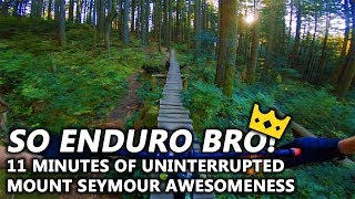
A North Shore classic, technical with plenty of roots and rocks and some optional woodwork. Descent only, please climb via the new Fungi Climb trail.

The old long skinny has been replaced with a coaster, but there are other skinnies to enjoy along the way.

Connect to Salvation for more woodwork and skinnies or continue to merge with Incline and exit via Power Line

Access Info

Easily accessed from the road, by riding up the road or parking at the "Vancouver Picnic Area" parking lot. Can also pedal up Mushroom Trail to access where it intersects with Incline and either ride from there or pedal up Fungi Climb to the top.

Trail Supporters
Local Trail Association

Recent Activity on Trail

Past Week
  • 31 rides
  • 11 miles average
6 Months
  • 809 rides
  • 10 miles avg distance
All
  • 7,115 rides
  • Last: Jun 25, 2026
c1c2c3c4
January
February
March
April
May
June
July
August
September
October
November
December
Status:
on Jun 13, 2026
Ideal
Avg: 4.35 (100 votes)
Your vote: 0

view (37,473)
close
3D
Trail Conditions
  • Unknown
  • Snow Groomed
  • Snow Packed
  • Snow Covered
  • Snow Cover Partial
  • Freeze/thaw Cycle
  • Icy
  • Prevalent Mud
  • Wet
  • Variable
  • Ideal
  • Dry
  • Very Dry
Trail Flow (Ridden Direction)
Trailforks scans users ridelogs to determine the most popular direction each trail is ridden. A good flowing trail network will have most trails flowing in a single direction according to their intension.
The colour categories are based on what percentage of riders are riding a trail in its intended direction.
  • > 96%
  • > 90%
  • > 80%
  • > 70%
  • > 50%
  • < 50%
  • bi-directional trail
  • no data
Trail Last Ridden
Trailforks scans ridelogs to determine the last time a trail was ridden.
  • < 2 days
  • < 1 week
  • < 2 weeks
  • < 1 month
  • < 6 months
  • > 6 months
Trail Ridden Direction
The intended direction a trail should be ridden.
  • Downhill Only
  • Downhill Primary
  • Both Directions
  • Uphill Primary
  • Uphill Only
  • One Direction
Contribute Details
Colors indicate trail is missing specified detail.
  • Description
  • Photos
  • Description & Photos
  • Videos
Trail Popularity ?
Trailforks scans ridelogs to determine which trails are ridden the most in the last 9 months. Trails are compared with nearby trails in the same city region with a possible 25 colour shades. Think of this as a heatmap, more rides = more kinetic energy = warmer colors.
  • most popular
  • popular
  • less popular
  • not popular
ATV/ORV/OHV Filter
Max Vehicle Width
inches
US Cell Coverage
Legend
cell carrier legend

Radar Time
Activity Recordings
Trailforks uses anonymized public activity data. ?
Activity Recordings
Trailforks uses anonymized public activity data. ?
Personal Heatmap
Activity Types
all / none
Options
2
Date range month
Winter Trails
Warning A routing network for winter maps does not exist. Selecting trails using the winter trails layer has been disabled.
Missing Trails
Most Popular
Least Popular
Trails are colored based on popularity. The more popular a trail is, the more red. Less popular trails trend towards green.
Jump Magnitude Heatmap
Heatmap of where riders jump on trails. Zoom in to see individual jumps, click circles to view jump details.
BC Backroad Status

Service Road Atlas is a free to use, community-driven service for viewing and creating reports on the numerous back-country service roads around B.C. and Alberta.

map legend
Slope Aspect
Direction the slope faces
Flat N NE E SE S SW W NW
Trails Deemphasized
Trails are shown in grey.
disable
Only show trails with no bike usage.
Enable
Suggested Layers
Based on selected activity type

    Save the current map location and zoom level as your default home location whenever this page is loaded.

    Save
        Directions to corkscrew trailhead (49.343450, -122.973690)

        Photos

        306 more »
        1,297 |
        Nov 14, 2015 @ 8:18pm
        Nov 14, 2015
        1,073 |
        Dec 21, 2014 @ 8:27pm
        Dec 21, 2014
        415 |
        Jun 26, 2015 @ 1:12am
        Jun 26, 2015
        88 |
        Feb 21, 2026 @ 3:51pm
        Feb 21, 2026

        Videos

        84 more »
        youtuber Are Modern 29ᵉʳs Any Good?
        20:31 | 605 | Apr 10, 2022 , North Vancouver
        youtuber Twenty Thousand
        21:10 | 590 | Feb 11, 2022 , North Vancouver
        youtuber
        12:35 | 862 | Dec 19, 2020 , North Vancouver
        youtuber 'So Enduro Bro' | Mount Seymour, North...
        11:28 | 1184 | Feb 3, 2019 , North Vancouver

        Routes with this trail

        3.0 7 miles 2,379 ft 10 Point to Point
        This route links together the seven smaller trails that climb from up to Baden Powell
        4.0 6 miles 1,636 ft 12 Loop
        Additional route to for a better work out and avoid the road.
        4.4 8 miles 2,164 ft 34 Loop
        This is one of our favorite routes on the North Shore and is featured in Freehub Magazine's Sea to Sky...

        25 Reviews & Comments


        We hope you've been enjoying Trailforks!

        Create a FREE account to view trail comments and much more.

        • By canadakaTF Pro Trailforks & contributors
        • #204 - 29,851 views

        Frequently Asked Questions About Corkscrew

        Where is Corkscrew located?
        Corkscrew is located in Mount Seymour, North Vancouver, British Columbia, Canada. It is part of the Mount Seymour trail network. The trailhead is located at coordinates 49.34345, -122.97369.
        How hard is Corkscrew?
        Corkscrew is rated as Black Diamond difficulty. The average grade is 15.1%.
        What is the elevation gain for Corkscrew?
        The trail has 206 ft of elevation descent. The elevation ranges from 1,624 ft to 1,830 ft.
        Is Corkscrew a point to point trail?
        Yes, Corkscrew is a point to point trail. The direction is Downhill Only. The trail type is singletrack.

        Hit the Trail

        Open in App

        Get this trail on your phone instantly.
        open trail in app

        Download Trail

        Save to wishlist, Garmin & download.
        save the trail

        Find Related Routes

        Find routes and users activities that include this trail.
        find routes for this trail

        You must enter a description before submitting.