more stats
1,253 ft
Distance
-193 ft
Descent
00:02:32
Avg time
-193 ft
Altitude change
1,853 ft
Altitude min
2,046 ft
Altitude max
2,046 ft
Altitude start
1,854 ft
Altitude end
-15.4%
Grade
-40.6%
Grade max
-3.2%
Grade min
1,253 ft
Distance down
00:02:32
Avg time

Egg Hunt Details

  • Activities
    • Mountain Bike
    • E-Bike
  • Riding Area
    Post Canyon
    Hood River, Oregon
  • Difficulty Rating
  • Voted Difficulty
    Double Black Diamond (4 votes)
  • Local Popularity
    45 in Mountain Biking [+]
    • 25 in E-Biking
  • Global Ranking
    #119092 in Mountain Biking [+]
    • #40087 in E-Biking
  • Trail Type
    Singletrack
  • Bike Type
    DH, AM, DJ
  • Direction
    Downhill Only
    Popular Direction Shown
  • Physical Rating
    Moderate
  • Dogs Allowed
    Yes
  • eBike Allowed
    Yes up to Class 1
  • TTFs on Trail
    Berm, Drop, Gap Jump, Ladder Bridge
  • Land Owner
    HRC Forestry Dept

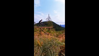
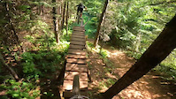
Short and sweet trail- a few notable features. Gap jumps to the famed 'Barn Door' to 'Woodlicka' Did you know there's a feature called the "Never Ending Skinny" located near the barn door? Next time your there- walk that little trail 15ft down when your scoping the BD and you'll gander at a historic gem! Be careful- its a legit challenge. Many brake rotors have died there......

Trail Supporters
Local Trail Association

Recent Activity on Trail

Past Week
  • 0 rides
  •  
6 Months
  • 14 rides
  • 17 miles avg distance
All
  • 128 rides
  • Last: Jun 24, 2026
c1c2c3c4
January
February
March
April
May
June
July
August
September
October
November
December
update trails status or condition

Egg Hunt Trail Reports

statusdatedescription
Nov 22, 2025 @ 7:31pm (America/Los_Angeles)
Nov 22, 2025
Appears to be open (11-22-25) Watch for the bomb hole in the main drop landing
May 5, 2025 @ 11:39am
May 5, 2025
Still closed, appears to be under construction/renovation
Aug 3, 2024 @ 4:54pm
Aug 3, 2024
Still closed
Jun 11, 2024 @ 5:46am
Jun 11, 2024
Still closed
May 4, 2023 @ 7:49am
May 4, 2023
reporter Closed for salvage logging. Estimated reopening 5/11/23
more »
Status:
on Nov 22, 2025
Variable
Avg: 4.27 (5 votes)
Your vote: 0

view (511)
close
3D
Trail Conditions
  • Unknown
  • Snow Groomed
  • Snow Packed
  • Snow Covered
  • Snow Cover Partial
  • Freeze/thaw Cycle
  • Icy
  • Prevalent Mud
  • Wet
  • Variable
  • Ideal
  • Dry
  • Very Dry
Trail Flow (Ridden Direction)
Trailforks scans users ridelogs to determine the most popular direction each trail is ridden. A good flowing trail network will have most trails flowing in a single direction according to their intension.
The colour categories are based on what percentage of riders are riding a trail in its intended direction.
  • > 96%
  • > 90%
  • > 80%
  • > 70%
  • > 50%
  • < 50%
  • bi-directional trail
  • no data
Trail Last Ridden
Trailforks scans ridelogs to determine the last time a trail was ridden.
  • < 2 days
  • < 1 week
  • < 2 weeks
  • < 1 month
  • < 6 months
  • > 6 months
Trail Ridden Direction
The intended direction a trail should be ridden.
  • Downhill Only
  • Downhill Primary
  • Both Directions
  • Uphill Primary
  • Uphill Only
  • One Direction
Contribute Details
Colors indicate trail is missing specified detail.
  • Description
  • Photos
  • Description & Photos
  • Videos
Trail Popularity ?
Trailforks scans ridelogs to determine which trails are ridden the most in the last 9 months. Trails are compared with nearby trails in the same city region with a possible 25 colour shades. Think of this as a heatmap, more rides = more kinetic energy = warmer colors.
  • most popular
  • popular
  • less popular
  • not popular
ATV/ORV/OHV Filter
Max Vehicle Width
inches
US Cell Coverage
Legend
cell carrier legend

Radar Time
Activity Recordings
Trailforks uses anonymized public activity data. ?
Activity Recordings
Trailforks uses anonymized public activity data. ?
Personal Heatmap
Activity Types
all / none
Options
2
Date range month
Winter Trails
Warning A routing network for winter maps does not exist. Selecting trails using the winter trails layer has been disabled.
Missing Trails
Most Popular
Least Popular
Trails are colored based on popularity. The more popular a trail is, the more red. Less popular trails trend towards green.
Jump Magnitude Heatmap
Heatmap of where riders jump on trails. Zoom in to see individual jumps, click circles to view jump details.
BC Backroad Status

Service Road Atlas is a free to use, community-driven service for viewing and creating reports on the numerous back-country service roads around B.C. and Alberta.

map legend
Slope Aspect
Direction the slope faces
Flat N NE E SE S SW W NW
Trails Deemphasized
Trails are shown in grey.
disable
Only show trails with no bike usage.
Enable
Suggested Layers
Based on selected activity type

    Save the current map location and zoom level as your default home location whenever this page is loaded.

    Save
        Directions to egg-hunt trailhead (45.669252, -121.626849)

        Photos

        9 more »
        1,735 |
        Nov 21, 2006 @ 1:01am
        Nov 21, 2006
        150 |
        Aug 25, 2022 @ 10:57am
        Aug 25, 2022
        577 |
        Oct 8, 2021 @ 7:47am
        Oct 8, 2021
        277 |
        Apr 24, 2021 @ 9:47pm
        Apr 24, 2021

        Videos

        9 more »
        Post Canyon Sends with Friends in Hood River, OR
        12:06 | 561 | Aug 31, 2021 , Hood River
        Post Canyon Sends ⚡
        0:16 | 356 | Aug 26, 2021 , Hood River
        Egg Hunt (Barn Door) - Post Canyon
        0:19 | 1740 | Apr 28, 2018 , Hood River
        Barn door
        0:02 | 634 | Jul 28, 2022 , Hood River

        Routes with this trail

        5.0 56 miles 10,060 ft 81 Loop
        The idea for this was to do a course with all Post Canyon trails that are availabe at Trailforks with the...
        3.0 11 miles 2,104 ft 27 Out & Back
        This is my route every time I make the trip to Hood River

        Trail Products

        Reviews / Comments

        No reviews yet, be the first to write a review or ask a question.
        Use trail reports to comment on trail conditions.


        We hope you've been enjoying Trailforks!

        Create a FREE account to view trail comments and much more.

        Frequently Asked Questions About Egg Hunt

        Where is Egg Hunt located?
        Egg Hunt is located in Post Canyon, Hood River, Oregon, United States. It is part of the Post Canyon trail network. The trailhead is located at coordinates 45.66925, -121.62685.
        How hard is Egg Hunt?
        Egg Hunt is rated as Black Diamond difficulty. The physical rating is Moderate. The average grade is 15.4%.
        What is the elevation gain for Egg Hunt?
        The trail has 193 ft of elevation descent. The elevation ranges from 1,853 ft to 2,046 ft.
        Is Egg Hunt a point to point trail?
        Yes, Egg Hunt is a point to point trail. The direction is Downhill Only. The trail type is singletrack.

        Hit the Trail

        Open in App

        Get this trail on your phone instantly.
        open trail in app

        Download Trail

        Save to wishlist, Garmin & download.
        save the trail

        Find Related Routes

        Find routes and users activities that include this trail.
        find routes for this trail

        You must enter a description before submitting.