784 ft
Distance
-68 ft
Descent
00:03:41
Avg time
Trail Supporters, Builders & Maintainers of FMX Trail
Hood River Bicycles
since 2017
FMX Details
-
Riding AreaPost Canyon
Hood River, Oregon -
Difficulty Rating
-
Trail TypeMachine Groomed
-
Bike TypeDH, AM, DJ
-
Trail UsageBiking Only
-
DirectionDownhill OnlyPopular direction shown
-
Physical RatingEasy
-
Dogs AllowedYes
-
TTFs on TrailBerm, Jump, Gap Jump
-
Global Ranking#14038 in Mountain Biking
-
Local Popularity35 in Mountain Biking
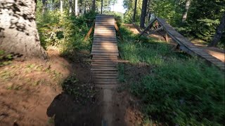
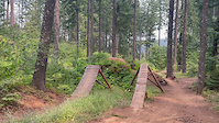
Best jumps in Post Canyon. Featured in many videos. Wooden TTF's with dirt landings. Two lines- an easier 'warm up' line that consists of 4 jumps- progressively bigger. 4th jump is really fun! Can be hard to judge speed for since they are all blind hucks off of flat takeoffs. Advanced line- three jumps- big wooden style slopestyle blasters. Very trickable. Great spot to session.
Access Info
Riorden Hill Road
Local Trail Association
-
Hood River Area Trail Stewards
(hrats.org) Please consider joining or donating to the local riding association to support trail development & maintenance.donate to earn trail karma!
More Stats for FMX bike trail
-
Altitude change-68 ft
-
Altitude min2,034 ft
-
Altitude max2,102 ft
-
Altitude start2,102 ft
-
Altitude end2,034 ft
-
Grade-8.665%
-
Grade max-12.34%
-
Grade min-2.017%
-
Distance down784 ft
-
Avg time00:03:41
- view trail stats
close
Trail Conditions
- Unknown
- Snow Groomed
- Snow Packed
- Snow Covered
- Freeze/thaw Cycle
- Icy
- Prevalent Mud
- Wet
- Variable
- Dry
- Very Dry
Trail Ridden Direction
Trailforks scans users ridelogs to determine the most popular direction each trail is ridden. A good flowing trail network will have most trails flowing in a single direction according to their intension.
The colour categories are based on what percentage of riders are riding a trail in its intended direction.
- > 96%
- > 90%
- > 80%
- > 70%
- > 50%
- < 50%
Trail Last Ridden
Trailforks scans ridelogs to determine the last time a trail was ridden.
- < 2 days
- < 1 week
- < 2 weeks
- < 1 month
- < 6 months
- > 6 months
Trail Ridden Direction
The intendid direction a trail should be ridden.
- Downhill Only
- Downhill Primary
- Both Directions
- Uphill Primary
- Uphill Only
- One Direction
ContributeDetails
Colors indicate trail is missing specified detail.
- Description
- Photos
- Description & Photos
- Videos
LEGEND
Trail Difficulties
Trail Report Status
- Access Road/Trail
- White
- Green
- Blue
- Black
- Double Black Diamond
Trail Report Status
- Clear / Green
- Minor Issue / Yellow
- Significant Issue / Amber
- Closed or Major Issue / Red
- Land Owner Overlay
- Wilderness (typically no bikes in USA)
- BLM (public)
- USFS (Wildlife sanctuaries darker than usfs)
- State land
- Indigenous
- Military
Trail Conditions
- Unknown
- Snow Groomed
- Snow Packed
- Snow Covered
- Freeze/thaw Cycle
- Icy
- Prevalent Mud
- Wet
- Variable
- Dry
- Very Dry
- Map Markers
Trail Head
Photo
Directory Listing
Riding Area
TTF
Parking
Viewpoint
Information
Warning
Directions
Water Fountain/Source
Sight
Restrooms
Gate
Camping
Trail Sign
Table or Bench
eBike Charging Point
Other
Directions to fmx trailhead
(45.668530, -121.631420)
update trails status or condition
FMX Trail Reports
view all reports »
Recent Ridelog Activity on Trail
Past Week
- 0 rides
6 Months
- 21 rides
- 14 miles avg distance
All
- 152 rides
Photos
more »
Trail Products
PB News Articles
May 3, 2010

Due to commitments with my training schedule, an interview at NASA and the Sea Otter Classic all falling on the same weekend, I had to replicate...
Reviews / Comments
No reviews yet, be the first to write a review or ask a question.
Use trail reports to comment on trail conditions.
Videos
more »
Nearby Trails
- connector 1,227 ft
- 130 1,227 ft
- connector 1,483 ft
- 140 hybrid xc lower 1,549 ft
- post canyon drive 1,644 ft
- embed FMX trail on your website
- By up4down HRATS & contributors
- #56319 - 1,344 views
- subscribe
- login to download gpx or kml files.
Open trail in mobile app