338 ft
Distance
-80 ft
Descent
00:02:18
Avg time
Supporters, Builders, Maintainers & Land Managers of Empress Trail
  • past supporters

Empress Details

  • Activities
    • Mountain Bike
    • E-Bike
    • Hike
    • Trail Running
  • Riding Area
    Mount Seymour
    North Vancouver, British Columbia
  • Difficulty Rating
  • Voted Difficulty
    Double Black Diamond (5 votes)
  • Trail Type
    Singletrack
  • Bike Type
    DH
  • Direction
    Downhill Only
    Popular direction shown
  • Dogs Allowed
    Yes
  • eBike Allowed
  • TTFs on Trail
    Drop, Rock Face
  • Ride in Rain
    Yes
  • Global Ranking
    #1192 in Mountain Biking [+]
    • #13625 in Trail Running
    • #14345 in Hiking
  • Land Owner
    DNV/BC Parks

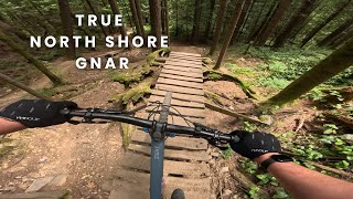
Consists of steep rock faces and loose dirt terrain. Short but contains high consequence natural terrain.

Access Info

Accessed from Bridle Path and finishes on Empress Bypass trail.

Local Trail Association
More Stats for Empress mountain bike trail trail
  • Altitude change
    -80 ft
  • Altitude min
    588 ft
  • Altitude max
    668 ft
  • Altitude start
    668 ft
  • Altitude end
    587 ft
  • Grade
    -23.8%
  • Grade max
    -35.3%
  • Grade min
    -8.1%
  • Distance down
    338 ft
  • Avg time
    00:02:18
  • Avg reverse time
    00:06:00
  • view trail stats
Status:
on Jan 26, 2025
Variable
Avg: 4.39 (50 votes)
Your vote: 0

view (4,124)
close
3D
Trail Conditions
  • Unknown
  • Snow Groomed
  • Snow Packed
  • Snow Covered
  • Snow Cover Partial
  • Freeze/thaw Cycle
  • Icy
  • Prevalent Mud
  • Wet
  • Variable
  • Ideal
  • Dry
  • Very Dry
Trail Flow (Ridden Direction)
Trailforks scans users ridelogs to determine the most popular direction each trail is ridden. A good flowing trail network will have most trails flowing in a single direction according to their intension.
The colour categories are based on what percentage of riders are riding a trail in its intended direction.
  • > 96%
  • > 90%
  • > 80%
  • > 70%
  • > 50%
  • < 50%
  • bi-directional trail
  • no data
Trail Last Ridden
Trailforks scans ridelogs to determine the last time a trail was ridden.
  • < 2 days
  • < 1 week
  • < 2 weeks
  • < 1 month
  • < 6 months
  • > 6 months
Trail Ridden Direction
The intended direction a trail should be ridden.
  • Downhill Only
  • Downhill Primary
  • Both Directions
  • Uphill Primary
  • Uphill Only
  • One Direction
Contribute Details
Colors indicate trail is missing specified detail.
  • Description
  • Photos
  • Description & Photos
  • Videos
Trail Popularity ?
Trailforks scans ridelogs to determine which trails are ridden the most in the last 9 months. Trails are compared with nearby trails in the same city region with a possible 25 colour shades. Think of this as a heatmap, more rides = more kinetic energy = warmer colors.
  • most popular
  • popular
  • less popular
  • not popular
ATV/ORV/OHV Filter
Max Vehicle Width
inches
US Cell Coverage
Legend
cell carrier legend

Radar Time
x Activity Recordings
Trailforks users anonymized public ridelogs from the past 6 months.
  • mountain biking recent
  • mountain biking (>6 month)
  • hiking (1 year)
  • moto (1 year)
Activity Recordings
Trailforks users anonymized public skilogs from the past 12 months.
  • Downhill Ski
  • Backcountry Ski
  • Nordic Ski
  • Snowmobile
Winter Trails
Warning A routing network for winter maps does not exist. Selecting trails using the winter trails layer has been disabled.
x Missing Trails
Most Popular
Least Popular
Trails are colored based on popularity. The more popular a trail is, the more red. Less popular trails trend towards green.
Jump Magnitude Heatmap
Heatmap of where riders jump on trails. Zoom in to see individual jumps, click circles to view jump details.
Trails Deemphasized
Trails are shown in grey.
disable
Only show trails with NO bikes.
enable

Save the current map location and zoom level as your default home location whenever this page is loaded.

Save
      Directions to empress trailhead (49.325950, -122.975320)
      update trails status or condition

      Empress Trail Reports

      statusdatedescription
      Jan 26, 2025 @ 11:27am
      Jan 26, 2025
      Dec 2, 2024 @ 7:58am
      Dec 2, 2024
      Trail is wet, but riding well. No issues!!
      Aug 17, 2024 @ 2:35pm
      Aug 17, 2024
      Jun 21, 2024 @ 3:49am
      Jun 21, 2024
      Jan 22, 2024 @ 1:15pm
      Jan 22, 2024
      Ice down the last section. You can’t see it until it’s too late
      view all reports »

      Recent Ridelog Activity on Trail

      Past Week
      • 0 rides
      •  
      6 Months
      • 27 rides
      • 9 miles avg distance
      All
      • 1,605 rides
      • Last: Feb 1, 2025

      Photos

      more »
      892 |
      Sep 9, 2014 @ 4:46pm
      Sep 9, 2014
      961 |
      Apr 6, 2010 @ 8:09pm
      Apr 6, 2010
      908 |
      Sep 9, 2014 @ 4:47pm
      Sep 9, 2014
      278 |
      Jun 1, 2020 @ 12:21am
      Jun 1, 2020

      Routes with this trail

      titledistance
      Crazy 8's14 miles
      Seymour Epic East Side Technical Tour7 miles
      Great loop.7 miles

      8 Reviews & Comments


      We hope you've been enjoying Trailforks!

      Create a FREE account to view trail comments and much more.

      Videos

      more »
      youtuber Redemption
      16:28 | 341 | Aug 7, 2022 , North Vancouver
      youtuber Enduro Racing for 【$5】
      12:25 | 237 | May 22, 2022 , North Vancouver
      youtuber Empress | Mount Seymour | Mountain Biking
      2:14 | 2062 | Jan 27, 2018 , North Vancouver
      Lower Boogieman // Empress - Mt. Seymour,...
      2:23 | 36 | Sep 1, 2024 , North Vancouver
      • By canadakaTF Pro Trailforks & contributors
      • #247 - 16,896 views

      You must enter a description before submitting.