more stats
3,163 ft
Distance
-641 ft
Descent
00:10:47
Avg time
-641 ft
Altitude change
1,669 ft
Altitude min
2,310 ft
Altitude max
2,310 ft
Altitude start
1,670 ft
Altitude end
-20.3%
Grade
-69.8%
Grade max
-6.8%
Grade min
3,163 ft
Distance down
00:10:47
Avg time

Executioner Details

  • Activities
    • Mountain Bike
    • E-Bike
    • Hike
    • Trail Running
  • Riding Area
    Mount Fromme
    North Vancouver, British Columbia
  • Difficulty Rating
  • Voted Difficulty
    Black Diamond (5 votes)
  • Local Popularity
    75 in Mountain Biking [+]
    • 80 in E-Biking
    • 55 in Trail Running
    • 75 in Hiking
  • Global Ranking
    #24151 in Mountain Biking [+]
    • #32408 in E-Biking
    • #90986 in Trail Running
    • #62103 in Hiking
  • Trail Type
    Singletrack
  • Bike Type
    DH, AM
  • Direction
    Downhill Primary
    Popular Direction Shown
  • Dogs Allowed
    Yes
  • eBike Allowed
  • Land Owner
    Grouse (upper) & DNV (lower) combination

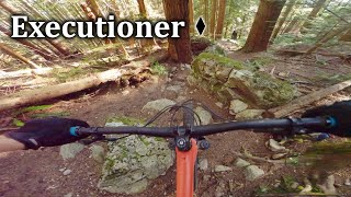
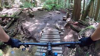
Executioner is an old school fall line trail, at times steep, tight & twisty, rooty & raw with some wide open tech sections.

The trail flows right into Dreamweaver offering a great descent. Or, if you've got the gusto, turn right on Dreamweaver to climb No Quarter and do it all over again

Access Info

Accessed off Mountain Hwy before the 6th switchback, exits on Dreamweaver.

Trail Supporters

Recent Activity on Trail

Past Week
  • 1 rides
  • 41 miles average
6 Months
  • 72 rides
  • 9 miles avg distance
All
  • 1,113 rides
  • Last: Jun 3, 2026
c1c2c3c4
January
February
March
April
May
June
July
August
September
October
November
December
Status:
on Apr 24, 2026
Ideal
Avg: 4.08 (58 votes)
Your vote: 0

view (7,052)
close
3D
Trail Conditions
  • Unknown
  • Snow Groomed
  • Snow Packed
  • Snow Covered
  • Snow Cover Partial
  • Freeze/thaw Cycle
  • Icy
  • Prevalent Mud
  • Wet
  • Variable
  • Ideal
  • Dry
  • Very Dry
Trail Flow (Ridden Direction)
Trailforks scans users ridelogs to determine the most popular direction each trail is ridden. A good flowing trail network will have most trails flowing in a single direction according to their intension.
The colour categories are based on what percentage of riders are riding a trail in its intended direction.
  • > 96%
  • > 90%
  • > 80%
  • > 70%
  • > 50%
  • < 50%
  • bi-directional trail
  • no data
Trail Last Ridden
Trailforks scans ridelogs to determine the last time a trail was ridden.
  • < 2 days
  • < 1 week
  • < 2 weeks
  • < 1 month
  • < 6 months
  • > 6 months
Trail Ridden Direction
The intended direction a trail should be ridden.
  • Downhill Only
  • Downhill Primary
  • Both Directions
  • Uphill Primary
  • Uphill Only
  • One Direction
Contribute Details
Colors indicate trail is missing specified detail.
  • Description
  • Photos
  • Description & Photos
  • Videos
Trail Popularity ?
Trailforks scans ridelogs to determine which trails are ridden the most in the last 9 months. Trails are compared with nearby trails in the same city region with a possible 25 colour shades. Think of this as a heatmap, more rides = more kinetic energy = warmer colors.
  • most popular
  • popular
  • less popular
  • not popular
ATV/ORV/OHV Filter
Max Vehicle Width
inches
US Cell Coverage
Legend
cell carrier legend

Radar Time
Activity Recordings
Trailforks uses anonymized public activity data. ?
Activity Recordings
Trailforks uses anonymized public activity data. ?
Personal Heatmap
Activity Types
all / none
Options
2
Date range month
Winter Trails
Warning A routing network for winter maps does not exist. Selecting trails using the winter trails layer has been disabled.
Missing Trails
Most Popular
Least Popular
Trails are colored based on popularity. The more popular a trail is, the more red. Less popular trails trend towards green.
Jump Magnitude Heatmap
Heatmap of where riders jump on trails. Zoom in to see individual jumps, click circles to view jump details.
BC Backroad Status

Service Road Atlas is a free to use, community-driven service for viewing and creating reports on the numerous back-country service roads around B.C. and Alberta.

map legend
Slope Aspect
Direction the slope faces
Flat N NE E SE S SW W NW
Trails Deemphasized
Trails are shown in grey.
disable
Only show trails with no bike usage.
Enable
Suggested Layers
Based on selected activity type

    Save the current map location and zoom level as your default home location whenever this page is loaded.

    Save
        Directions to executioner trailhead (49.361330, -123.066800)

        Photos

        70 more »
        80 |
        Aug 27, 2024 @ 11:51pm
        Aug 27, 2024
        77 |
        Aug 27, 2024 @ 11:51pm
        Aug 27, 2024
        89 |
        Aug 27, 2024 @ 11:51pm
        Aug 27, 2024
        266 |
        Jul 23, 2022 @ 11:04pm
        Jul 23, 2022

        Videos

        13 more »
        North Shore Chonk | Executioner - Fromme
        7:30 | 378 | Nov 29, 2024 , North Vancouver
        youtuber Executioner and Dreamweaver
        7:23 | 342 | Jul 16, 2024 , North Vancouver
        Executing the Dreamweaver Chill
        16:32 | 210 | Apr 5, 2024 , North Vancouver
        Dying on Executioner
        508 | Jun 22, 2020 , North Vancouver

        Trail Lists

        Routes with this trail

        3.8 3 miles 1,468 ft 14 Point to Point
        Collection of new climbing connectors and some old trail creating a Fromme west side access climbing...
        3.8 37 miles 7,397 ft 25 Point to Point
        North Shore Tripple crown No unsanctioned trails
        5.0 6 miles 1,816 ft 32 Loop
        Get a taste of old school North Shore trails with this tech gnar route. Best served dry unless you want...

        3 Reviews & Comments


        We hope you've been enjoying Trailforks!

        Create a FREE account to view trail comments and much more.

        • By canadakaTF Pro Trailforks & contributors
        • #162 - 29,148 views

        Frequently Asked Questions About Executioner

        Where is Executioner located?
        Executioner is located in Mount Fromme, North Vancouver, British Columbia, Canada. It is part of the Mount Fromme trail network. The trailhead is located at coordinates 49.36133, -123.0668.
        How hard is Executioner?
        Executioner is rated as Black Diamond difficulty. The average grade is 20.3%.
        What is the elevation gain for Executioner?
        The trail has 195 m of elevation descent. The elevation ranges from 509 m to 704 m.
        Is Executioner a point to point trail?
        Executioner is not a point to point trail. The direction is Downhill Primary. The trail type is singletrack.

        Hit the Trail

        Open in App

        Get this trail on your phone instantly.
        open trail in app

        Download Trail

        Save to wishlist, Garmin & download.
        save the trail

        Find Related Routes

        Find routes and users activities that include this trail.
        find routes for this trail

        You must enter a description before submitting.