4,751 ft
Distance
26 ft
Climb
-670 ft
Descent
00:11:20
Avg time
Supporters, Builders, Maintainers & Land Managers of Dreamweaver Trail

Dreamweaver Details

  • Activities
    • Mountain Bike
    • Hike
    • Trail Running
  • Riding Area
    Mount Fromme
    North Vancouver, British Columbia
  • Difficulty Rating
  • Voted Difficulty
    Blue (2 votes)
  • Hiking SAC Scale
    T1 Hiking
  • Trail Type
    Singletrack
  • Bike Type
    AM, XC
  • Direction
    Downhill Primary
    Popular direction shown
  • Climb Difficulty
    Black Diamond
  • Physical Rating
    Moderate
  • Season
    year round
  • Dogs Allowed
    Yes
  • TTFs on Trail
    Bridge
  • Ride in Rain
    Yes
  • Global Ranking
    #1269 in Mountain Biking [+]
    • #2197 in Trail Running
    • #2532 in Hiking
  • Local Popularity
    85 in Mountain Biking [+]
    • 60 in Trail Running
    • 80 in Hiking
  • Land Owner
    District of North Vancouver

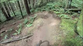
Few TTFs, able to accommodate most rider levels. All Mountain downhill trail would be the best description as it has some short climbs and in general requires pedalling. Challenging to navigate near the bottom as it intersects many old trails but simply go straight through when in doubt. Be sure not to miss the left uphill when intersecting St. Georges otherwise you're in for a rowdy downhill
When emerging on Skid Road, the original DW descent goes straight or you can take the Skid Road Connector to the left (just after crossing Skid Rd) but be sure to watch for uphill traffic. If you take the left fork, you'll end up on St. Mary's and eventually on Dempsey. Take the original descent for a more dh oriented ride.

Local Trail Association
More Stats for Dreamweaver multi-use trail trail
  • Altitude change
    -644 ft
  • Altitude min
    868 ft
  • Altitude max
    1,537 ft
  • Altitude start
    1,512 ft
  • Altitude end
    869 ft
  • Grade
    -13.5%
  • Grade max
    -54.2%
  • Grade min
    23.1%
  • Distance climb
    387 ft
  • Distance down
    3,999 ft
  • Distance flat
    364 ft
  • Avg time
    00:11:20
  • Avg reverse time
    00:15:26
  • view trail stats
Status:
on Mar 22, 2023
Ideal
Avg: 3.5 (52 votes)
Your vote: 0

view (6,162)
close
3D
Trail Conditions
  • Unknown
  • Snow Groomed
  • Snow Packed
  • Snow Covered
  • Snow Cover Inadequate
  • Freeze/thaw Cycle
  • Icy
  • Prevalent Mud
  • Wet
  • Variable
  • Ideal
  • Dry
  • Very Dry
Trail Flow (Ridden Direction)
Trailforks scans users ridelogs to determine the most popular direction each trail is ridden. A good flowing trail network will have most trails flowing in a single direction according to their intension.
The colour categories are based on what percentage of riders are riding a trail in its intended direction.
  • > 96%
  • > 90%
  • > 80%
  • > 70%
  • > 50%
  • < 50%
  • bi-directional trail
  • no data
Trail Last Ridden
Trailforks scans ridelogs to determine the last time a trail was ridden.
  • < 2 days
  • < 1 week
  • < 2 weeks
  • < 1 month
  • < 6 months
  • > 6 months
Trail Ridden Direction
The intended direction a trail should be ridden.
  • Downhill Only
  • Downhill Primary
  • Both Directions
  • Uphill Primary
  • Uphill Only
  • One Direction
Contribute Details
Colors indicate trail is missing specified detail.
  • Description
  • Photos
  • Description & Photos
  • Videos
Trail Popularity ?
Trailforks scans ridelogs to determine which trails are ridden the most in the last 9 months. Trails are compared with nearby trails in the same city region with a possible 25 colour shades. Think of this as a heatmap, more rides = more kinetic energy = warmer colors.
  • most popular
  • popular
  • less popular
  • not popular
ATV/ORV/OHV Filter
Max Vehicle Width
inches

Radar Time
x Activity Recordings
Trailforks users anonymized public ridelogs from the past 6 months.
  • mountain biking recent
  • mountain biking (>6 month)
  • hiking (1 year)
  • moto (1 year)
Activity Recordings
Trailforks users anonymized public skilogs from the past 12 months.
  • Downhill Ski
  • Backcountry Ski
  • Nordic Ski
  • Snowmobile
Jump Magnitude Heatmap
Heatmap of where riders jump on trails. Zoom in to see individual jumps, click circles to view jump details.
Trails Deemphasized
Trails are shown in grey.
disable
Only show trails with NO bikes.
enable

Save the current map location and zoom level as your default home location whenever this page is loaded.

Save
      Directions to dreamweaver trailhead (49.354040, -123.067950)
      update trails status or condition

      Dreamweaver Trail Reports

      statusdatedescription
      Mar 22, 2023 @ 9:32am
      Mar 22, 2023
      Mar 18, 2023 @ 1:18am
      Mar 18, 2023
      Mar 17, 2023 @ 9:52pm
      Mar 17, 2023
      Running most excellently. Only a bit of snow on the BP traverse to the start; Dreamweaver is totally clear.
      Mar 16, 2023 @ 7:45pm
      Mar 16, 2023
      reporter Bottom bit from skid road down is great. New work is awesome!
      Mar 13, 2023 @ 8:57pm
      Mar 13, 2023
      Good condition. No snow lower down.
      view all reports »

      Recent Ridelog Activity on Trail

      Past Week
      • 30 rides
      • 6 miles avg distance
      6 Months
      • 385 rides
      • 7 miles avg distance
      All
      • 5,683 rides
      • Last: Mar 29, 2023

      Photos

      more »
      115 |
      Sep 15, 2020 @ 8:42pm
      Sep 15, 2020
      102 |
      Apr 27, 2020 @ 6:31pm
      Apr 27, 2020
      108 |
      Apr 27, 2020 @ 6:31pm
      Apr 27, 2020
      337 |
      May 12, 2016 @ 1:38am
      May 12, 2016

      Trail Lists

      Routes with this trail

      more »
      titledistance
      No Quarter (Fromme Climbing Route)3 miles
      North Shore Triple Crown - Legal37 miles
      Kickin It Old School6 miles
      Lower Fromme Loop8 miles

      10 Reviews & Comments


      We hope you've been enjoying Trailforks!

      Create a FREE account to view trail comments and much more.

      Videos

      more »
      youtuber GoPro Hero 9 Lens Mod - MTB Test Ride
      7:22 | 853 | Nov 27, 2020 , North Vancouver
      Dreamweaver | Mt.Fromme | Sounds Of Nature
      8:52 | 2212 | Oct 10, 2018 , North Vancouver
      Dreamweaver 2011
      5:04 | 1862 | Sep 19, 2011 , North Vancouver
      Risky Passing on Mt. Fromme
      2:34 | 249 | Jul 23, 2020 , North Vancouver
      • subscribe
      • flag
      • login to download gpx or kml files.