more stats
4,341 ft
Distance
34 ft
Climb
-258 ft
Descent
00:10:11
Avg time
-223 ft
Altitude change
805 ft
Altitude min
1,029 ft
Altitude max
1,029 ft
Altitude start
807 ft
Altitude end
-5.1%
Grade
-43%
Grade max
8.6%
Grade min
860 ft
Distance climb
2,992 ft
Distance down
489 ft
Distance flat
00:10:11
Avg time

Fox Run Details

  • Activities
    • Mountain Bike
    • E-Bike
    • Adaptive Bike
    • Winter Fat Bike
    • Hike
    • Trail Running
    • Snowshoe
  • Riding Area
    Kingdom Trails
    East Burke, Vermont
  • Difficulty Rating
  • Local Popularity
    80 in Mountain Biking [+]
    • 85 in E-Biking
    • 65 in Trail Running
    • 85 in Hiking
    • 75 in Snowshoeing
  • Global Ranking
    #23783 in Mountain Biking [+]
    • #33851 in E-Biking
    • #101404 in Trail Running
    • #53048 in Hiking
    • #3132 in Snowshoeing
  • Hiking SAC Scale
    T1 Hiking
  • Trail Type
    Machine Groomed
  • Snow Grooming
    Groomed Smooth
  • Bike Type
    AM, XC, Fat, Adaptive MTB
  • Direction
    Both Directions
  • Climb Difficulty
    Blue
  • Physical Rating
    Moderate
  • Trail Visibility
    Always easy to follow
  • eBike Allowed
  • Land Owner
    Kingdom Trail Association

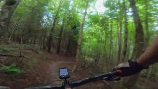
Fox Run is the main connection between the hub at the Wild Flower Inn and the trails at the Southern end of Darling Hill. It is a moderate single track, fast and flowy going down and a moderate climb coming back up. The trail surface is generally firm, hard-pack, with no significant technical obstacles.

Access Info

Fox Run starts at the top end on Bemis (near the Skills Park, just below the Wildflower Inn) and at the lower end it joins first with the lower end of Meadow Wood (on the left) and, a little further down, it joins the intersection of River Run (to the north) and Violet's Outback (to the south).

Disclaimer

The VAST is a primary use snowmobile trail. Fat bikers must yield to snowmobile traffic. Please respect the trail closure signs. No Fat Bikes to go beyond the point where signs are posted.

Local Trail Association
Traditionally Indigenous Territory

Recent Activity on Trail

Past Week
  • 22 rides
  • 14 miles average
6 Months
  • 110 rides
  • 13 miles avg distance
All
  • 1,861 rides
  • Last: Jun 29, 2026
c1c2c3c4
January
February
March
April
May
June
July
August
September
October
November
December
update trails status or condition

Fox Run Trail Reports

statusdatedescription
Jun 25, 2026 @ 2:34pm (America/New_York)
Jun 25, 2026
Apr 24, 2026 @ 2:52pm (America/New_York)
Apr 24, 2026
reporter Southwest section of Darling Hill trails are open!
Apr 18, 2026 @ 11:30am (America/New_York)
Apr 18, 2026
reporter The Wildflower Backyard trails are open for the 2026 season! The rest of the network still needs time to dry out, but we will continue to open...
Oct 31, 2025 @ 9:47pm (America/New_York)
Oct 31, 2025
reporter Winter trails will open after Vermont's deer hunting season concludes AND once the ground is frozen. https://www.kingdomtrails.org/Trail-Conditions
Oct 29, 2025 @ 7:43pm (America/New_York)
Oct 29, 2025
more »
Status:
on Jun 25, 2026
Ideal
Avg: 3.21 (8 votes)
Your vote: 0

view (6,771)
close
3D
Trail Conditions
  • Unknown
  • Snow Groomed
  • Snow Packed
  • Snow Covered
  • Snow Cover Partial
  • Freeze/thaw Cycle
  • Icy
  • Prevalent Mud
  • Wet
  • Variable
  • Ideal
  • Dry
  • Very Dry
Trail Flow (Ridden Direction)
Trailforks scans users ridelogs to determine the most popular direction each trail is ridden. A good flowing trail network will have most trails flowing in a single direction according to their intension.
The colour categories are based on what percentage of riders are riding a trail in its intended direction.
  • > 96%
  • > 90%
  • > 80%
  • > 70%
  • > 50%
  • < 50%
  • bi-directional trail
  • no data
Trail Last Ridden
Trailforks scans ridelogs to determine the last time a trail was ridden.
  • < 2 days
  • < 1 week
  • < 2 weeks
  • < 1 month
  • < 6 months
  • > 6 months
Trail Ridden Direction
The intended direction a trail should be ridden.
  • Downhill Only
  • Downhill Primary
  • Both Directions
  • Uphill Primary
  • Uphill Only
  • One Direction
Contribute Details
Colors indicate trail is missing specified detail.
  • Description
  • Photos
  • Description & Photos
  • Videos
Trail Popularity ?
Trailforks scans ridelogs to determine which trails are ridden the most in the last 9 months. Trails are compared with nearby trails in the same city region with a possible 25 colour shades. Think of this as a heatmap, more rides = more kinetic energy = warmer colors.
  • most popular
  • popular
  • less popular
  • not popular
ATV/ORV/OHV Filter
Max Vehicle Width
inches
US Cell Coverage
Legend
cell carrier legend

Radar Time
Activity Recordings
Trailforks uses anonymized public activity data. ?
Activity Recordings
Trailforks uses anonymized public activity data. ?
Personal Heatmap
Activity Types
all / none
Options
2
Date range month
Winter Trails
Warning A routing network for winter maps does not exist. Selecting trails using the winter trails layer has been disabled.
Missing Trails
Most Popular
Least Popular
Trails are colored based on popularity. The more popular a trail is, the more red. Less popular trails trend towards green.
Jump Magnitude Heatmap
Heatmap of where riders jump on trails. Zoom in to see individual jumps, click circles to view jump details.
BC Backroad Status

Service Road Atlas is a free to use, community-driven service for viewing and creating reports on the numerous back-country service roads around B.C. and Alberta.

map legend
Slope Aspect
Direction the slope faces
Flat N NE E SE S SW W NW
Trails Deemphasized
Trails are shown in grey.
disable
Only show trails with no bike usage.
Enable
Suggested Layers
Based on selected activity type

    Save the current map location and zoom level as your default home location whenever this page is loaded.

    Save
        Directions to fox-run trailhead (44.575710, -71.972810)

        Photos

        12 more »
        108 |
        Aug 18, 2018 @ 7:11am
        Aug 18, 2018
        97 |
        Aug 18, 2018 @ 7:10am
        Aug 18, 2018
        113 |
        Aug 18, 2018 @ 7:06am
        Aug 18, 2018
        136 |
        Aug 18, 2018 @ 6:46am
        Aug 18, 2018

        Videos

        1 more »
        Fox Run & New T Trails at Kingdom Trails -...
        7:10 | 309 | Sep 1, 2022 , East Burke

        Trail Lists

        Routes with this trail

        2 miles 331 ft 7 Loop
        A 2.5 mile with 400ft of . This route is designed for beginner riders and follows green circle and blue...
        6 miles 736 ft 10 Loop
        up on Darling Hill starting from VSS Trailside. Super fun down hill from to and .
        6 miles 626 ft 6 Loop
        A route for my mom, nothing wild or epic except fo the views. A mellow with beautiful scenery ending at...

        Reviews / Comments

        No reviews yet, be the first to write a review or ask a question.
        Use trail reports to comment on trail conditions.


        We hope you've been enjoying Trailforks!

        Create a FREE account to view trail comments and much more.

        Frequently Asked Questions About Fox Run

        Where is Fox Run located?
        Fox Run is located in Kingdom Trails, East Burke, Vermont, United States. It is part of the Kingdom Trails trail network. The trailhead is located at coordinates 44.57571, -71.97281.
        How hard is Fox Run?
        Fox Run is rated as Blue difficulty. The physical rating is Moderate. The average grade is 5.1%. The climb difficulty is rated Blue.
        What is the elevation gain for Fox Run?
        Fox Run has 34 ft of elevation gain. The trail has 258 ft of elevation descent. The elevation ranges from 805 ft to 1,029 ft.
        Is Fox Run a point to point trail?
        Fox Run is not a point to point trail. The direction is Both Directions. The trail type is machine groomed.

        Hit the Trail

        Open in App

        Get this trail on your phone instantly.
        open trail in app

        Download Trail

        Save to wishlist, Garmin & download.
        save the trail

        Find Related Routes

        Find routes and users activities that include this trail.
        find routes for this trail

        You must enter a description before submitting.