


Open in App
Get this trail on your phone instantly.

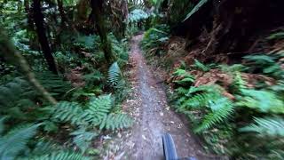
The Hatu Patu trail is rideable - well, rideable for MTB Zen masters. One of the three Department of Conservation trails - along with Tuhoto Ariki (1) and Te Tihi O Tawa (3) on the eastern edge of the Whaka Forest. Distance: 1km MTB only The trail is grade 5/6/HC - rooty, lots of off camber and sections you need to carry momentum to clear.
It starts at the top of the last descent of Tuhoto Ariki - the native bush trail that starts from the top of Tawa Rd, in Whaka forest. Hatu Patu ends near the bottom of Billy T on Moerangi Rd.
The trail was surveyed with funding from the Lion Foundation and constructed by spade and rake wielding volunteers led by Mike and Rob from Bike Culture on Wednesday evening working bees through the summer. DOC helped out with chainsawing some of the fallen logs over the 1km - ish route. This is another cool addition to the track network, but be warned it is tricky, there are only a couple of riders who have made it through with no dabs, so treat it as a challenge.
Tuhourangi iwi, the Department of Conservation and the RMTBC are all partners in this innovative trail initiative. Tuhourangi iwi kaumatua, Anaru Rangiheuea, named it Hatupatu, after a young man who came to Aotearoa on the Arawa canoe and who used to hunt in the forests around Rotorua. “It’s great the trail network has names that draw attention to the history and legends of this area, adding another dimension to the experience,” says Dave Donaldson, who was one of the main movers in the construction of Tuhoto Ariki and Hatupatu. Google “Hatupatu” for more about him, including the story of how he hid from the bird woman, Kurangaituku behind a rock near Atiamuri, now known as Hatupatu’s Rock.
Entrance is from Tuhoto Ariki trail. Most riders ride from the Tuhoto Ariki trailhead at the highest point of the forest on Tawa Rd.
Because Tuhoto Ariki is one of Rotorua's few two-way tracks it is also legitimately accessed from the other direction - by heading up Tuhoto Ariki's last section from the Moerangi Road. end.
| c1 | c2 | c3 | c4 |
|---|---|---|---|
January | February | March | April |
May | June | July | August |
September | October | November | December |

Service Road Atlas is a free to use, community-driven service for viewing and creating reports on the numerous back-country service roads around B.C. and Alberta.
Save the current map location and zoom level as your default home location whenever this page is loaded.
SaveWe hope you've been enjoying Trailforks!
Create a FREE account to view trail comments and much more.
You must enter a description before submitting.

