more stats
1,378 ft
Distance
-260 ft
Descent
00:12:59
Avg time
-260 ft
Altitude change
1,340 ft
Altitude min
1,600 ft
Altitude max
1,600 ft
Altitude start
1,339 ft
Altitude end
-18.9%
Grade
-42.1%
Grade max
-3.8%
Grade min
1,378 ft
Distance down
00:12:59
Avg time

Mandatory Caution Details

  • Activities
    • Mountain Bike
    • Hike
    • Trail Running
  • Riding Area
    Woodlot
    Maple Ridge, British Columbia
  • Difficulty Rating
  • Voted Difficulty
    Black Diamond (1 vote)
  • Local Popularity
    45 in Mountain Biking [+]
    • 25 in Trail Running
    • 5 in Hiking
  • Global Ranking
    #89805 in Mountain Biking [+]
    • #125678 in Trail Running
    • #130331 in Hiking
  • Trail Type
    Singletrack
  • Bike Type
    DH, AM
  • Dogs Allowed
    Yes
  • eBike Allowed
  • TTFs on Trail
    A-Frame, Bridge, Drop, Jump, Gap Jump, Ladder Bridge, Log Ride, Skinny

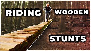
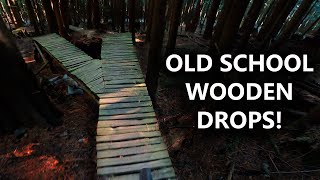
Overall a steep natural technical trail with lots of woodwork from skinnies & log rides to drops & jumps, some mandatory, some optional. Most woodwork was rebuilt in 2023. (Note: features at the exit of trail were not rebuilt as it is expected this portion of the trail will be logged within the next couple of years)

Local Trail Association

Recent Activity on Trail

Past Week
  • 1 rides
  • 8 miles average
6 Months
  • 10 rides
  • 8 miles avg distance
All
  • 102 rides
  • Last: Jun 27, 2026
c1c2c3c4
January
February
March
April
May
June
July
August
September
October
November
December
update trails status or condition

Mandatory Caution Trail Reports

statusdatedescription
Jun 10, 2026 @ 2:58pm (America/Vancouver)
Jun 10, 2026
reporter Bottom of trail repaired. Fresh dirt on landings and a couple berms. Rebuilt a small wood feature near the bottom. Added a downramp to one of the...
May 17, 2026 @ 11:04am (America/Vancouver)
May 17, 2026
trail is currently open. may close unexpectedly for logging.
May 16, 2026 @ 10:27am (America/Vancouver)
May 16, 2026
tree cleared on May 11, my buddy and I were able to drag it :) Forgot to post.
Apr 23, 2026 @ 4:31pm (America/Vancouver)
Apr 23, 2026
Fallen tree in middle portion of trail about 6" in diameter. Will likely need a saw due to its positioning between other trees. Too high to ride over.
Apr 11, 2026 @ 6:04pm (America/Vancouver)
Apr 11, 2026
reporter Trail has been re-opened. Watch for soft dirt at the end.
more »
Status:
on Jun 10, 2026
Ideal
Avg: 4 (27 votes)
Your vote: 0

view (449)
close
3D
Trail Conditions
  • Unknown
  • Snow Groomed
  • Snow Packed
  • Snow Covered
  • Snow Cover Partial
  • Freeze/thaw Cycle
  • Icy
  • Prevalent Mud
  • Wet
  • Variable
  • Ideal
  • Dry
  • Very Dry
Trail Flow (Ridden Direction)
Trailforks scans users ridelogs to determine the most popular direction each trail is ridden. A good flowing trail network will have most trails flowing in a single direction according to their intension.
The colour categories are based on what percentage of riders are riding a trail in its intended direction.
  • > 96%
  • > 90%
  • > 80%
  • > 70%
  • > 50%
  • < 50%
  • bi-directional trail
  • no data
Trail Last Ridden
Trailforks scans ridelogs to determine the last time a trail was ridden.
  • < 2 days
  • < 1 week
  • < 2 weeks
  • < 1 month
  • < 6 months
  • > 6 months
Trail Ridden Direction
The intended direction a trail should be ridden.
  • Downhill Only
  • Downhill Primary
  • Both Directions
  • Uphill Primary
  • Uphill Only
  • One Direction
Contribute Details
Colors indicate trail is missing specified detail.
  • Description
  • Photos
  • Description & Photos
  • Videos
Trail Popularity ?
Trailforks scans ridelogs to determine which trails are ridden the most in the last 9 months. Trails are compared with nearby trails in the same city region with a possible 25 colour shades. Think of this as a heatmap, more rides = more kinetic energy = warmer colors.
  • most popular
  • popular
  • less popular
  • not popular
ATV/ORV/OHV Filter
Max Vehicle Width
inches
US Cell Coverage
Legend
cell carrier legend

Radar Time
Activity Recordings
Trailforks uses anonymized public activity data. ?
Activity Recordings
Trailforks uses anonymized public activity data. ?
Personal Heatmap
Activity Types
all / none
Options
2
Date range month
Winter Trails
Warning A routing network for winter maps does not exist. Selecting trails using the winter trails layer has been disabled.
Missing Trails
Most Popular
Least Popular
Trails are colored based on popularity. The more popular a trail is, the more red. Less popular trails trend towards green.
Jump Magnitude Heatmap
Heatmap of where riders jump on trails. Zoom in to see individual jumps, click circles to view jump details.
BC Backroad Status

Service Road Atlas is a free to use, community-driven service for viewing and creating reports on the numerous back-country service roads around B.C. and Alberta.

map legend
Slope Aspect
Direction the slope faces
Flat N NE E SE S SW W NW
Trails Deemphasized
Trails are shown in grey.
disable
Only show trails with no bike usage.
Enable
Suggested Layers
Based on selected activity type

    Save the current map location and zoom level as your default home location whenever this page is loaded.

    Save
        Directions to mandatory-caution trailhead (49.240050, -122.428040)

        Photos

        119 more »
        597 |
        Nov 2, 2012 @ 12:46pm
        Nov 2, 2012
        870 |
        Nov 2, 2012 @ 12:47pm
        Nov 2, 2012
        53 |
        Oct 15, 2024 @ 7:02pm
        Oct 15, 2024
        44 |
        Oct 15, 2024 @ 6:30pm
        Oct 15, 2024

        Videos

        14 more »
        youtuber I BROKE MY TEETH! // JORDAN BOOSTMASTER //...
        7:02 | 467 | Dec 12, 2020 , Maple Ridge
        youtuber MANDATORY CAUTION | Single Black trail | Woodlot
        2:00 | 227 | Oct 19, 2024 , Maple Ridge
        MOUNTAIN BIKING ON WOODEN STUNTS - Mandatory...
        4:36 | 493 | Nov 21, 2020 , Maple Ridge
        Mandatory Caution // The Woodlot
        2:04 | 388 | Nov 12, 2020 , Maple Ridge

        Trail Products

        6 Reviews & Comments


        We hope you've been enjoying Trailforks!

        Create a FREE account to view trail comments and much more.

        Nearby Trails

        • By BCpovTF Pro & contributors
        • #103 - 5,705 views

        Frequently Asked Questions About Mandatory Caution

        Where is Mandatory Caution located?
        Mandatory Caution is located in Woodlot, Maple Ridge, British Columbia, Canada. It is part of the Woodlot trail network. The trailhead is located at coordinates 49.24005, -122.42804.
        How hard is Mandatory Caution?
        Mandatory Caution is rated as Black Diamond difficulty. The average grade is 18.9%.
        What is the elevation gain for Mandatory Caution?
        The trail has 260 ft of elevation descent. The elevation ranges from 1,340 ft to 1,600 ft.
        How long is Mandatory Caution?
        Mandatory Caution is 1,378 ft long. The trail type is singletrack.

        Hit the Trail

        Open in App

        Get this trail on your phone instantly.
        open trail in app

        Download Trail

        Save to wishlist, Garmin & download.
        save the trail

        Find Related Routes

        Find routes and users activities that include this trail.
        find routes for this trail

        You must enter a description before submitting.