1,125 ft
Distance
-135 ft
Descent
00:03:38
Avg time
Supporters, Builders, Maintainers & Land Managers of Upper Toadstool Trail

Upper Toadstool Details

  • Activities
    • Mountain Bike
    • Hike
    • Trail Running
  • Riding Area
    Woodlot
    Maple Ridge, British Columbia
  • AKA
    Upper Toad, Toad
  • Difficulty Rating
  • Voted Difficulty
    Black Diamond (1 vote)
  • Trail Type
    Singletrack
  • Bike Type
    DH, AM, XC
  • Direction
    Downhill Primary
    Popular direction shown
  • Physical Rating
    Moderate
  • Trail Visibility
    Always easy to follow
  • Dogs Allowed
    Yes
  • eBike Allowed
  • TTFs on Trail
    Bridge, Ladder Bridge, Log Ride, Rock Garden, Skinny
  • Global Ranking
    #40474 in Mountain Biking [+]
    • #24070 in Trail Running
    • #15383 in Hiking
  • Local Popularity
    65 in Mountain Biking [+]
    • 45 in Trail Running
    • 45 in Hiking

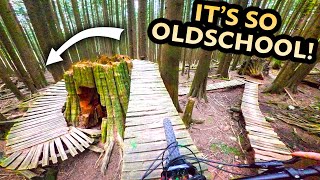
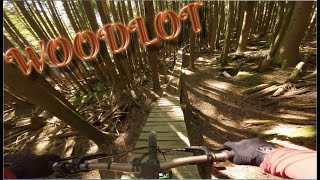
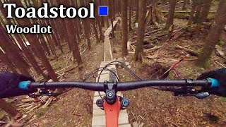
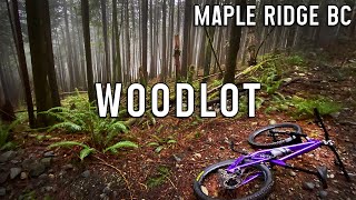
Flowy bench cut trail, accessed off Spur Road 2 near the end of Krazy Karpenter and flows directly into Lower Toadstool. Nice warm up trail with an optional log ride.

Local Trail Association
More Stats for Upper Toadstool mountain bike trail trail
  • Altitude change
    -135 ft
  • Altitude min
    1,502 ft
  • Altitude max
    1,637 ft
  • Altitude start
    1,637 ft
  • Altitude end
    1,503 ft
  • Grade
    -11.9%
  • Grade max
    -29.5%
  • Grade min
    -0.8%
  • Distance down
    1,086 ft
  • Distance flat
    39 ft
  • Avg time
    00:03:38
  • Avg reverse time
    00:08:55
  • view trail stats
Status:
on Mar 28, 2023
Variable
Avg: 3.35 (20 votes)
Your vote: 0

view (1,450)
close
3D
Trail Conditions
  • Unknown
  • Snow Groomed
  • Snow Packed
  • Snow Covered
  • Snow Cover Inadequate
  • Freeze/thaw Cycle
  • Icy
  • Prevalent Mud
  • Wet
  • Variable
  • Ideal
  • Dry
  • Very Dry
Trail Flow (Ridden Direction)
Trailforks scans users ridelogs to determine the most popular direction each trail is ridden. A good flowing trail network will have most trails flowing in a single direction according to their intension.
The colour categories are based on what percentage of riders are riding a trail in its intended direction.
  • > 96%
  • > 90%
  • > 80%
  • > 70%
  • > 50%
  • < 50%
  • bi-directional trail
  • no data
Trail Last Ridden
Trailforks scans ridelogs to determine the last time a trail was ridden.
  • < 2 days
  • < 1 week
  • < 2 weeks
  • < 1 month
  • < 6 months
  • > 6 months
Trail Ridden Direction
The intended direction a trail should be ridden.
  • Downhill Only
  • Downhill Primary
  • Both Directions
  • Uphill Primary
  • Uphill Only
  • One Direction
Contribute Details
Colors indicate trail is missing specified detail.
  • Description
  • Photos
  • Description & Photos
  • Videos
Trail Popularity ?
Trailforks scans ridelogs to determine which trails are ridden the most in the last 9 months. Trails are compared with nearby trails in the same city region with a possible 25 colour shades. Think of this as a heatmap, more rides = more kinetic energy = warmer colors.
  • most popular
  • popular
  • less popular
  • not popular
ATV/ORV/OHV Filter
Max Vehicle Width
inches

Radar Time
x Activity Recordings
Trailforks users anonymized public ridelogs from the past 6 months.
  • mountain biking recent
  • mountain biking (>6 month)
  • hiking (1 year)
  • moto (1 year)
Activity Recordings
Trailforks users anonymized public skilogs from the past 12 months.
  • Downhill Ski
  • Backcountry Ski
  • Nordic Ski
  • Snowmobile
Jump Magnitude Heatmap
Heatmap of where riders jump on trails. Zoom in to see individual jumps, click circles to view jump details.
Trails Deemphasized
Trails are shown in grey.
disable
Only show trails with NO bikes.
enable

Save the current map location and zoom level as your default home location whenever this page is loaded.

Save
      Directions to upper-toadstool trailhead (49.240060, -122.428790)
      update trails status or condition

      Upper Toadstool Trail Reports

      statusdatedescription
      Mar 28, 2023 @ 8:34pm
      Mar 28, 2023
      reporter Trail is activley being worked on and you may encounter changes or unfinished work. Please ride with care. I will post here when we're done.
      Mar 28, 2023 @ 7:07pm
      Mar 28, 2023
      Trail work at entrance….all good once in forest
      Feb 23, 2023 @ 4:21pm
      Feb 23, 2023
      The new work is hoar-frosted bigtime so be a bro and walk it. Otherwise its mint, amazing grip.
      Jan 19, 2023 @ 11:27am
      Jan 19, 2023
      reporter Trail work still in progress. Will be good when they are done!
      Dec 19, 2022 @ 9:14am
      Dec 19, 2022
      reporter Trail work in progress.
      view all reports »

      Recent Ridelog Activity on Trail

      Past Week
      • 1 rides
      • 7 miles avg distance
      6 Months
      • 67 rides
      • 6 miles avg distance
      All
      • 1,371 rides
      • Last: Mar 28, 2023

      Photos

      more »
      0 |
      Mar 28, 2023 @ 8:42pm
      Mar 28, 2023
      0 |
      Mar 28, 2023 @ 8:42pm
      Mar 28, 2023
      0 |
      Mar 28, 2023 @ 8:42pm
      Mar 28, 2023
      261 |
      Jul 29, 2015 @ 7:02pm
      Jul 29, 2015
      | 1 comments

      Routes with this trail

      titledistance
      Fraser Valley Woodlot Epic12 miles

      Trail Products

      3 Reviews & Comments


      We hope you've been enjoying Trailforks!

      Create a FREE account to view trail comments and much more.

      Videos

      more »
      Upper and Lower Toadstool
      5:01 | 605 | Apr 25, 2020 , Maple Ridge
      Pa g's 1st ride on The Woodlot Feb 28, 2020
      10:25 | 167 | Mar 1, 2020 , Maple Ridge
      | Jan 13, 2023 , Maple Ridge
      • subscribe
      • flag
      • login to download gpx or kml files.