more stats
1,680 ft
Distance
29 ft
Climb
-5 ft
Descent
00:02:25
Avg time
25 ft
Altitude change
507 ft
Altitude min
531 ft
Altitude max
507 ft
Altitude start
531 ft
Altitude end
1.5%
Grade
-3.9%
Grade max
4.8%
Grade min
925 ft
Distance climb
184 ft
Distance down
568 ft
Distance flat
00:02:25
Avg time

Mid Flow Details

  • Activities
    • Mountain Bike
    • Adaptive Bike
    • Hike
    • Trail Running
  • Riding Area
    Saxon Hill
    Essex, Vermont
  • Difficulty Rating
  • Local Popularity
    100 in Mountain Biking [+]
    • 100 in Trail Running
    • 100 in Hiking
  • Global Ranking
    #706 in Mountain Biking [+]
    • #5674 in Trail Running
    • #8155 in Hiking
  • Trail Type
    Singletrack
  • Bike Type
  • Dogs Allowed
    Yes

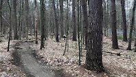
Wide connection trail on private land to access hill side. Heavy two way traffic, be respectful to oncoming users. There is no priority direction for this trail, when in doubt, yield.

Adaptive Bike Info
aMTB Green Rating: Beginner features and moderate terrain.

This trail is free of obstacles and low angle or flat in gradient. It is the primary access trail from the parking area to the other trails.

Local Trail Association
Traditionally Indigenous Territory

Recent Activity on Trail

Past Week
  • 42 rides
  • 7 miles average
6 Months
  • 279 rides
  • 7 miles avg distance
All
  • 3,575 rides
  • Last: Jun 3, 2026
c1c2c3c4
January
February
March
April
May
June
July
August
September
October
November
December
Status:
on Jun 3, 2026
Variable
Avg: 3.53 (6 votes)
Your vote: 0

view (28,451)
close
3D
Trail Conditions
  • Unknown
  • Snow Groomed
  • Snow Packed
  • Snow Covered
  • Snow Cover Partial
  • Freeze/thaw Cycle
  • Icy
  • Prevalent Mud
  • Wet
  • Variable
  • Ideal
  • Dry
  • Very Dry
Trail Flow (Ridden Direction)
Trailforks scans users ridelogs to determine the most popular direction each trail is ridden. A good flowing trail network will have most trails flowing in a single direction according to their intension.
The colour categories are based on what percentage of riders are riding a trail in its intended direction.
  • > 96%
  • > 90%
  • > 80%
  • > 70%
  • > 50%
  • < 50%
  • bi-directional trail
  • no data
Trail Last Ridden
Trailforks scans ridelogs to determine the last time a trail was ridden.
  • < 2 days
  • < 1 week
  • < 2 weeks
  • < 1 month
  • < 6 months
  • > 6 months
Trail Ridden Direction
The intended direction a trail should be ridden.
  • Downhill Only
  • Downhill Primary
  • Both Directions
  • Uphill Primary
  • Uphill Only
  • One Direction
Contribute Details
Colors indicate trail is missing specified detail.
  • Description
  • Photos
  • Description & Photos
  • Videos
Trail Popularity ?
Trailforks scans ridelogs to determine which trails are ridden the most in the last 9 months. Trails are compared with nearby trails in the same city region with a possible 25 colour shades. Think of this as a heatmap, more rides = more kinetic energy = warmer colors.
  • most popular
  • popular
  • less popular
  • not popular
ATV/ORV/OHV Filter
Max Vehicle Width
inches
US Cell Coverage
Legend
cell carrier legend

Radar Time
Activity Recordings
Trailforks uses anonymized public activity data. ?
Activity Recordings
Trailforks uses anonymized public activity data. ?
Personal Heatmap
Activity Types
all / none
Options
2
Date range month
Winter Trails
Warning A routing network for winter maps does not exist. Selecting trails using the winter trails layer has been disabled.
Missing Trails
Most Popular
Least Popular
Trails are colored based on popularity. The more popular a trail is, the more red. Less popular trails trend towards green.
Jump Magnitude Heatmap
Heatmap of where riders jump on trails. Zoom in to see individual jumps, click circles to view jump details.
BC Backroad Status

Service Road Atlas is a free to use, community-driven service for viewing and creating reports on the numerous back-country service roads around B.C. and Alberta.

map legend
Slope Aspect
Direction the slope faces
Flat N NE E SE S SW W NW
Trails Deemphasized
Trails are shown in grey.
disable
Only show trails with no bike usage.
Enable
Suggested Layers
Based on selected activity type

    Save the current map location and zoom level as your default home location whenever this page is loaded.

    Save
        Directions to mid-flow trailhead (44.493570, -73.036490)

        Photos

        3 more »
        84 |
        Dec 12, 2020 @ 12:19pm
        Dec 12, 2020
        37 |
        Nov 3, 2025 @ 6:19pm
        Nov 3, 2025
        84 |
        May 7, 2021 @ 5:14am
        May 7, 2021
        56 |
        Mar 27, 2020 @ 12:59pm
        Mar 27, 2020

        Videos

        3 more »
        Sick edit
        0:00 | 326 | Apr 3, 2020 , Essex
        Rock roll
        0:06 | 89 | Apr 3, 2020 , Essex
        Gap at Saxon hill
        0:10 | 166 | Apr 3, 2020 , Essex

        Routes with this trail

        4 miles 322 ft 6 Loop
        Great balance between easy cruising and a little more up and down. The Blue Saxonathon Route is roughly 4...
        9 miles 906 ft 7
        Warm up with a loop on the pond side starting with and . Then head across Thompson Drive to . Once at the...
        5 miles 278 ft 8 Loop
        A great intro to Saxon Hill or a quick cruising loop. Begin with and around the pond. Add on if you would...

        3 Reviews & Comments


        We hope you've been enjoying Trailforks!

        Create a FREE account to view trail comments and much more.

        • By StephaneMarceauTF Pro TRAILFORKS & contributors
        • #65048 - 2,095 views

        Frequently Asked Questions About Mid Flow

        Where is Mid Flow located?
        Mid Flow is located in Saxon Hill, Essex, Vermont, United States. It is part of the Saxon Hill trail network. The trailhead is located at coordinates 44.49357, -73.03649.
        How hard is Mid Flow?
        Mid Flow is rated as Green difficulty. The average grade is 1.5%.
        What is the elevation gain for Mid Flow?
        Mid Flow has 29 ft of elevation gain. The trail has 5 ft of elevation descent. The elevation ranges from 507 ft to 531 ft.
        How long is Mid Flow?
        Mid Flow is 1,680 ft long. The trail type is singletrack.

        Hit the Trail

        Open in App

        Get this trail on your phone instantly.
        open trail in app

        Download Trail

        Save to wishlist, Garmin & download.
        save the trail

        Find Related Routes

        Find routes and users activities that include this trail.
        find routes for this trail

        You must enter a description before submitting.