


Open in App
Get this trail on your phone instantly.

Overview
Have you replaced your brake pads yet? Might want to check them before heading out on this double-header day. If you ride both Hardesty and Lawler, as is frequently recommended, it is easy to arrange for the shuttle company to meet you after the first run and take back up. While this is a shuttle be prepared to do some climbing, but it is so worth it. Rugged, steep, and sometimes exposed, the trails will demand your attention all the way down.
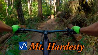
Route Details - Hardesty
Hardesty is an old access route to a now-defunct fire lookout tower, but you get to enjoy the trail without having to lug your provisions up the hill. The access road can be rough, with a washout near the top, so it’s best to have one of the local shuttle companies take you up there. Even with the vehicle assist, however, the trail starts with a short climb. In less than a mile until you’re at the top, ready to tap into 3,000’ of descending.
The trail sidehills across steep slopes and flanks ridgelines, heading down, down, down. Sometimes you’ll be riding next to massive fir trees that tower to the sky, other times you’ll pop into open meadows that plunge to the rivers below. Just when you get in a groove you’ll hit a switchback, so keep your head up. While the trail is not particularly technical it does offer plenty of exposure in places, and sometimes the switchbacks are preceded by steep run-ins to test your bike handling skills.
After a particularly exhilarating set of switchbacks the trail grade begins to soften and you’ll go from death-gripping the bars to having more fun. The landscape is a deep, dark green now, with moss and ferns covering everything in sight, including the rocks along the edge of the trail so don’t relax too much. If it is wet and the forest gnomes have been greasing the roots you’ll be sideways before you know it. Keep it mellow as the trail ends and connects with the Lower Goodman Trail to bring you to the trailhead along Highway 58.
Riding Season
Spring through fall.
Ascend Patterson Mountain Road (near mp 23 or 24 on HWY 58) until you reach the saddle of some mountains (you will know, it is clearly labeled with spur roads to Cottage Groove) The road to your right is the one to pick. .3 miles down the road is a large washout. It is easy to drive through with most trucks or cars with 4wd and very passable by bike. Keep heading down that road until it ends in a parking lot. The trail is very obvious from there. Make sure you do not turn down the Sawtooth trail at any point in the first mile or so.
| c1 | c2 | c3 | c4 |
|---|---|---|---|
January | February | March | April |
May | June | July | August |
September | October | November | December |

Service Road Atlas is a free to use, community-driven service for viewing and creating reports on the numerous back-country service roads around B.C. and Alberta.
Save the current map location and zoom level as your default home location whenever this page is loaded.
SaveWe hope you've been enjoying Trailforks!
Create a FREE account to view trail comments and much more.
You must enter a description before submitting.

