2,087 ft
Distance
36 ft
Climb
-118 ft
Descent
00:05:24
Avg time
Supporters, Builders, Maintainers & Land Managers of Night Shift Trail
  • past supporters

Night Shift Details

  • Activities
    • Mountain Bike
    • E-Bike
    • Hike
    • Trail Running
  • Riding Area
    Hartland Mountain Bike Park
    Victoria, British Columbia
  • Difficulty Rating
  • Hiking SAC Scale
    T2 Mountain Hiking
  • Trail Type
    Singletrack
  • Bike Type
    XC
  • Direction
    Downhill Primary
    Popular direction shown
  • Climb Difficulty
    Black Diamond
  • Physical Rating
    Moderate
  • Trail Visibility
    Always easy to follow
  • Dogs Allowed
    Yes
  • eBike Allowed
    Yes up to Class 1
  • TTFs on Trail
    Bridge, Drop, Rock Face, Rock Garden
  • Ride in Rain
    Yes
  • Global Ranking
    #1872 in Mountain Biking [+]
    • #4734 in E-Biking
    • #19405 in Trail Running
    • #31234 in Hiking
  • Local Popularity
    85 in Mountain Biking [+]
    • 90 in E-Biking
    • 55 in Trail Running
    • 65 in Hiking
  • Land Owner

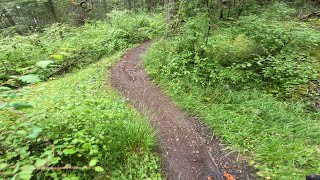
Built as an option to the Regional Trail fire road, this trail can be ridden in both directions and features a drystack rock bridge and a step-up.

In combination with Who's Your Daddy it makes a great ride and is part of the annual Dumpster Dive Super D race.

Local Trail Association
More Stats for Night Shift mountain bike trail trail
  • Altitude change
    -85 ft
  • Altitude min
    557 ft
  • Altitude max
    642 ft
  • Altitude start
    642 ft
  • Altitude end
    558 ft
  • Grade
    -4.1%
  • Grade max
    -18.1%
  • Grade min
    19.2%
  • Distance climb
    413 ft
  • Distance down
    1,214 ft
  • Distance flat
    459 ft
  • Avg time
    00:05:24
  • Avg reverse time
    00:07:07
  • view trail stats
Status:
on Jun 4, 2025
Dry
Avg: 3.6 (27 votes)
Your vote: 0

view (12,386)
close
3D
Trail Conditions
  • Unknown
  • Snow Groomed
  • Snow Packed
  • Snow Covered
  • Snow Cover Partial
  • Freeze/thaw Cycle
  • Icy
  • Prevalent Mud
  • Wet
  • Variable
  • Ideal
  • Dry
  • Very Dry
Trail Flow (Ridden Direction)
Trailforks scans users ridelogs to determine the most popular direction each trail is ridden. A good flowing trail network will have most trails flowing in a single direction according to their intension.
The colour categories are based on what percentage of riders are riding a trail in its intended direction.
  • > 96%
  • > 90%
  • > 80%
  • > 70%
  • > 50%
  • < 50%
  • bi-directional trail
  • no data
Trail Last Ridden
Trailforks scans ridelogs to determine the last time a trail was ridden.
  • < 2 days
  • < 1 week
  • < 2 weeks
  • < 1 month
  • < 6 months
  • > 6 months
Trail Ridden Direction
The intended direction a trail should be ridden.
  • Downhill Only
  • Downhill Primary
  • Both Directions
  • Uphill Primary
  • Uphill Only
  • One Direction
Contribute Details
Colors indicate trail is missing specified detail.
  • Description
  • Photos
  • Description & Photos
  • Videos
Trail Popularity ?
Trailforks scans ridelogs to determine which trails are ridden the most in the last 9 months. Trails are compared with nearby trails in the same city region with a possible 25 colour shades. Think of this as a heatmap, more rides = more kinetic energy = warmer colors.
  • most popular
  • popular
  • less popular
  • not popular
ATV/ORV/OHV Filter
Max Vehicle Width
inches
US Cell Coverage
Legend
cell carrier legend

Radar Time
x Activity Recordings
Trailforks users anonymized public ridelogs from the past 6 months.
  • mountain biking recent
  • mountain biking (>6 month)
  • hiking (1 year)
  • moto (1 year)
Activity Recordings
Trailforks users anonymized public skilogs from the past 12 months.
  • Downhill Ski
  • Backcountry Ski
  • Nordic Ski
  • Snowmobile
Winter Trails
Warning A routing network for winter maps does not exist. Selecting trails using the winter trails layer has been disabled.
x Missing Trails
Most Popular
Least Popular
Trails are colored based on popularity. The more popular a trail is, the more red. Less popular trails trend towards green.
Jump Magnitude Heatmap
Heatmap of where riders jump on trails. Zoom in to see individual jumps, click circles to view jump details.
Trails Deemphasized
Trails are shown in grey.
disable
Only show trails with NO bikes.
enable

Save the current map location and zoom level as your default home location whenever this page is loaded.

Save
      Directions to night-shift trailhead (48.533530, -123.464950)

      Recent Ridelog Activity on Trail

      Past Week
      • 18 rides
      • 6 miles avg distance
      6 Months
      • 260 rides
      • 8 miles avg distance
      All
      • 2,797 rides
      • Last: Jun 18, 2025

      Photos

      more »
      544 |
      May 11, 2011 @ 9:04pm
      May 11, 2011
      730 |
      Dec 28, 2015 @ 11:23am
      Dec 28, 2015
      138 |
      Oct 5, 2008 @ 11:38pm
      Oct 5, 2008
      168 |
      Oct 5, 2008 @ 11:38pm
      Oct 5, 2008

      2 Reviews & Comments


      We hope you've been enjoying Trailforks!

      Create a FREE account to view trail comments and much more.

      Videos

      more »
      Who's Your Daddy - Night Shift - Hartland 2024
      9:48 | 40 | Oct 6, 2024 , Victoria
      Night Shift - Hartland Mountain Bike Park,...
      2:50 | 72 | May 27, 2024 , Victoria
      Night Shift at Hartland Bike Park, Saanich, BC
      3:31 | 84 | Nov 3, 2023 , Victoria
      Night Shift (Climb) at Hartland Bike Park,...
      5:55 | 55 | Oct 21, 2023 , Victoria
      • By KZ-Powned & contributors
      • #1137 - 4,485 views

      You must enter a description before submitting.