

more stats
5,184 ft
Distance
-652 ft
Descent
00:09:53
Avg time
-653 ft
Altitude change
1,143 ft
Altitude min
1,796 ft
Altitude max
1,796 ft
Altitude start
1,142 ft
Altitude end
-12.6%
Grade
-53%
Grade max
-0.7%
Grade min
5,095 ft
Distance down
89 ft
Distance flat
00:09:53
Avg time

Ono Details

  • Activities
    • Mountain Bike
    • E-Bike
    • Hike
    • Trail Running
  • Riding Area
  • Difficulty Rating
  • Voted Difficulty
    Proline (2 votes)
  • Local Popularity
    55 in Mountain Biking [+]
    • 65 in E-Biking
    • 80 in Trail Running
    • 90 in Hiking
  • Global Ranking
    #12050 in Mountain Biking [+]
    • #36593 in E-Biking
    • #72173 in Trail Running
    • #83970 in Hiking
  • State Ranking
    #297 in Mountain Biking · California [+]
    • #798 in E-Biking
    • #3,501 in Trail Running
    • #4,787 in Hiking
  • Hiking SAC Scale
    T3 Demanding Mountain Hiking
  • Trail Type
    Singletrack
  • Bike Type
    DH, AM
  • Direction
    Downhill Only
    Popular Direction Shown
  • Dogs Allowed
    Yes
  • eBike Allowed
    Yes up to Class 1
  • TTFs on Trail
    Berm, Drop, Jump, Log Ride, Rock Face, Rock Garden
  • Ride in Rain
    Yes
  • Year Opened
    2024

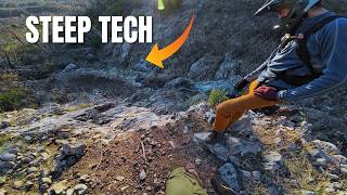
The lower section of Ono is a hand built downhill mountain bike trail located on the south west side of mule mt. This trail features technical features such as rock gardens, rock slabs and a large step-down near the bottom. Overall this trail is more of a black diamond trail, but there are a few spicy moves that might be considered more at home on a double black diamond trail. As with all advanced trails, we ask that you scope out the more technical sections of trail before riding them.

The trail is open to foot traffic, so please be respectful of other trail users.

Trail Supporters

  • Sponsor

Local Trail Association

Traditionally Indigenous Territory

Recent Activity on Trail

Past Week
  • 0 rides
  •  
6 Months
  • 7 rides
  • 12 miles avg distance
All
  • 51 rides
  • Last: Oct 5, 2026
c1c2c3c4
January
February
March
April
May
June
July
August
September
October
November
December
update trails status or condition

Ono Trail Reports

statusdatedescription
Apr 3, 2026 @ 8:05am (America/Los_Angeles)
Apr 3, 2026
reporter The RTA crew has brushed back the trail and done work on a few of the more sketchy spots, including building a nice catch at the bottom of the...
Mar 16, 2026 @ 9:32am (America/Los_Angeles)
Mar 16, 2026
Loose. A little overgrown in places.
Mar 18, 2025 @ 2:05pm
Mar 18, 2025
Mar 11, 2025 @ 2:36pm
Mar 11, 2025
Jan 29, 2025 @ 2:29pm
Jan 29, 2025
One tree down on blind corner, just a hundred feet or so from the bottom.
more »
Status:
on Apr 3, 2026
Dry
Avg: 4.33 (6 votes)
Your vote: 0

view (223)
close
      Directions to ono trailhead (40.549570, -122.517020)

      Photos

      13 more »
      mtb
      Ono
      208 |
      Nov 29, 2024 @ 9:21am
      Nov 29, 2024
      mtb
      Ono
      232 |
      Nov 28, 2024 @ 6:36am
      Nov 28, 2024
      mtb
      Ono
      242 |
      Jul 23, 2024 @ 9:02am
      Jul 23, 2024
      mtb
      Ono
      246 |
      Jul 23, 2024 @ 9:02am
      Jul 23, 2024

      Videos

      1 more »
      This trail has SERIOUS consequences…
      mtb
      15:50 | 405 | Dec 15, 2024 , Redding

      Routes with this trail

      6 miles • 1,382 ft • 5 • Loop •
      Okay, here we go with a challenging rock/hike climb with the reward of amazing views and wonder as to how...
      6 miles • 1,375 ft • 5 • Loop •
      Looking for as tech tough as Swasey has to offer, here you go. This route includes a challenging climb and...
      7 miles • 1,136 ft • 4 • Loop •
      This Bigfoot Adventure Challenge route starts with a difficult, rocky climb to the Boheh Sas trail around...
      4.7 ★★★★★
      6 Ratings
      5 ★ 67%
      4 ★ 33%
      3 ★
      2 ★
      1 ★

      10 Reviews & Comments

      Oldschool55 Oldschool55
      Gnarly, multiple drops with loose rock/slate.
      gabrielamadeus gabrielamadeus
      Great trail, the top half is much steeper than the photos look. Excellent mix of awkward tech moves, some flow, and steep committing slabs. 🤘
      concretekahuna concretekahuna
      I agree with the trail description, this is a solid black with some spicy features. Nowhere near as commiting as a true double black or pro line would be.

      That said, this is a beautifully built trail and it's really fun. Definitely a must do if you're visiting. Great work trail crew.

      We hope you've been enjoying Trailforks!

      Create a FREE account to view all trail reviews and much more.

      • By ReddingRiderTF Pro RTA & contributors
      • #742898 - 2,297 views

      Frequently Asked Questions

      ▼ Where is Ono located?
      Ono is located in Mule Ridge and Swasey Recreation Area, Redding, California, United States. It is part of the Mule Ridge and Swasey Recreation Area trail network. The trailhead is located at coordinates 40.54957, -122.51702.
      ▼ How hard is Ono?
      Ono is rated as Double Black Diamond difficulty. The average grade is 12.6%.
      ▼ What is the elevation gain for Ono?
      The trail has 652 ft of elevation descent. The elevation ranges from 1,143 ft to 1,796 ft.
      ▼ Is Ono a point to point trail?
      Yes, Ono is a point to point trail. The direction is Downhill Only. The trail type is singletrack.
      ▼ How long is Ono?
      Ono is 5,184 ft long. The trail type is singletrack.
      ▼ Are dogs allowed on Ono?
      Yes, dogs are allowed on Ono. Please keep dogs on a leash where required and clean up after them.
      ▼ When is the best time of year to ride Ono?
      Based on activity log data, the most popular months to ride Ono are:
      • April (15 activities)
      • May (10 activities)
      • October (4 activities)
      Check the reports page for current trail conditions.
      ▼ How do I access Ono? Where is the closest parking trailhead?
      The closest parking and trailhead locations to Ono are: View all parking locations in the area.
      ▼ How long does it take to ride Ono?
      Based on recorded activities, it takes an average of 10 minutes to ride Ono. The trail is 5,184 ft long. Actual times will vary based on fitness level, conditions, and pace. View recent activity logs for more details.
      ▼ How busy is Ono?
      Ono is a moderately popular trail. There have been 219 recorded activities on this trail. The trail has received 223 check-ins. View recent activity on this trail.

      Hit the Trail

      Open in App

      Get this trail on your phone instantly.

      open trail in app

      Download Trail

      Save to wishlist, Garmin & download.
      save the trail

      Find Related Routes

      Find routes and users activities that include this trail.
      find routes for this trail

      You must enter a description before submitting.