1.2 miles
Distance
183 ft
Climb
-584 ft
Descent
00:39:20
Avg time

Out There Details

  • Activities
    • Mountain Bike
    • E-Bike
    • Hike
    • Trail Running
  • Riding Area
    Whistler North
    Whistler, British Columbia
  • Difficulty Rating
  • Voted Difficulty
    Double Black Diamond (6 votes)
  • Trail Type
    Singletrack
  • Bike Type
    AM
  • Direction
    Downhill Only
    Popular direction shown
  • Physical Rating
    Moderate
  • Season
    May-October
  • Dogs Allowed
    Yes
  • eBike Allowed
    Yes up to Class 1
  • TTFs on Trail
    Bridge, Rock Face
  • Ride in Rain
    Yes
  • Global Ranking
    #1008 in Mountain Biking [+]
    • #5959 in E-Biking
    • #3598 in Trail Running
    • #20019 in Hiking
  • Local Popularity
    75 in Mountain Biking [+]
    • 65 in E-Biking
    • 20 in Trail Running
    • 60 in Hiking
  • Year Opened
    2014

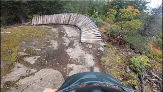
Trail starts with some punchy up and downs and an awesome viewpoint overlooking the valley. Then the trail gets really fun with many rock slabs and lush green moss covered forests.

Access Info

Climb Comfortably Numb until the bridge over rethel creek. Turn left (signed)

Local Trail Association
More Stats for Out There mountain bike trail trail
  • Altitude change
    -401 ft
  • Altitude min
    2,096 ft
  • Altitude max
    2,637 ft
  • Altitude start
    2,497 ft
  • Altitude end
    2,096 ft
  • Grade
    -6.1%
  • Grade max
    -37.6%
  • Grade min
    36.5%
  • Distance climb
    1,552 ft
  • Distance down
    4,656 ft
  • Distance flat
    322 ft
  • Avg time
    00:39:20
  • Avg reverse time
    01:21:30
  • view trail stats
Status:
on Apr 21, 2025
Ideal
Avg: 4.67 (73 votes)
Your vote: 0

view (4,473)
close
3D
Trail Conditions
  • Unknown
  • Snow Groomed
  • Snow Packed
  • Snow Covered
  • Snow Cover Partial
  • Freeze/thaw Cycle
  • Icy
  • Prevalent Mud
  • Wet
  • Variable
  • Ideal
  • Dry
  • Very Dry
Trail Flow (Ridden Direction)
Trailforks scans users ridelogs to determine the most popular direction each trail is ridden. A good flowing trail network will have most trails flowing in a single direction according to their intension.
The colour categories are based on what percentage of riders are riding a trail in its intended direction.
  • > 96%
  • > 90%
  • > 80%
  • > 70%
  • > 50%
  • < 50%
  • bi-directional trail
  • no data
Trail Last Ridden
Trailforks scans ridelogs to determine the last time a trail was ridden.
  • < 2 days
  • < 1 week
  • < 2 weeks
  • < 1 month
  • < 6 months
  • > 6 months
Trail Ridden Direction
The intended direction a trail should be ridden.
  • Downhill Only
  • Downhill Primary
  • Both Directions
  • Uphill Primary
  • Uphill Only
  • One Direction
Contribute Details
Colors indicate trail is missing specified detail.
  • Description
  • Photos
  • Description & Photos
  • Videos
Trail Popularity ?
Trailforks scans ridelogs to determine which trails are ridden the most in the last 9 months. Trails are compared with nearby trails in the same city region with a possible 25 colour shades. Think of this as a heatmap, more rides = more kinetic energy = warmer colors.
  • most popular
  • popular
  • less popular
  • not popular
ATV/ORV/OHV Filter
Max Vehicle Width
inches
US Cell Coverage
Legend
cell carrier legend

Radar Time
x Activity Recordings
Trailforks users anonymized public ridelogs from the past 6 months.
  • mountain biking recent
  • mountain biking (>6 month)
  • hiking (1 year)
  • moto (1 year)
Activity Recordings
Trailforks users anonymized public skilogs from the past 12 months.
  • Downhill Ski
  • Backcountry Ski
  • Nordic Ski
  • Snowmobile
Winter Trails
Warning A routing network for winter maps does not exist. Selecting trails using the winter trails layer has been disabled.
x Missing Trails
Most Popular
Least Popular
Trails are colored based on popularity. The more popular a trail is, the more red. Less popular trails trend towards green.
Jump Magnitude Heatmap
Heatmap of where riders jump on trails. Zoom in to see individual jumps, click circles to view jump details.
Trails Deemphasized
Trails are shown in grey.
disable
Only show trails with NO bikes.
enable

Save the current map location and zoom level as your default home location whenever this page is loaded.

Save
      Directions to out-there trailhead (50.159960, -122.878460)
      update trails status or condition

      Out There Trail Reports

      statusdatedescription
      Apr 21, 2025 @ 8:51pm
      Apr 21, 2025
      Trees are gone, all clear.
      Apr 18, 2025 @ 3:46pm
      Apr 18, 2025
      A couple decent sized trees down on one of the ride arounds to the big, smooth convex roll.
      Apr 13, 2025 @ 6:56pm
      Apr 13, 2025
      Running well!
      Apr 7, 2025 @ 5:27pm
      Apr 7, 2025
      Oct 11, 2024 @ 3:17pm
      Oct 11, 2024
      running well, but some wet/muddy spots, and some of the off camber is greasy
      view all reports »

      Recent Ridelog Activity on Trail

      Past Week
      • 7 rides
      • 8.6 km avg distance
      6 Months
      • 16 rides
      • 9.1 km avg distance
      All
      • 741 rides
      • Last: Apr 29, 2025

      Photos

      more »
      298 |
      Aug 19, 2017 @ 11:28pm
      Aug 19, 2017
      219 |
      Aug 19, 2017 @ 11:27pm
      Aug 19, 2017
      63 |
      Aug 15, 2023 @ 12:58pm
      Aug 15, 2023
      54 |
      Aug 15, 2023 @ 12:58pm
      Aug 15, 2023

      Trail Lists

      Trail Products

      11 Reviews & Comments


      We hope you've been enjoying Trailforks!

      Create a FREE account to view trail comments and much more.

      Videos

      more »
      youtuber Whistler Tech Trails are Built Different
      11:54 | 95 | Aug 11, 2024 , Whistler
      youtuber Out There - Whistler Mountain Biking - Sea to...
      7:18 | 704 | May 10, 2022 , Whistler
      youtuber Escape the Crowds: Top Single Black Trail in...
      12:27 | 158 | Jul 24, 2024 , Whistler
      youtuber Whistler Valley Trails  OUT THERE  One of the...
      12:24 | 1216 | Jul 23, 2020 , Whistler
      • By mahonlamontTF Pro SIMBS & contributors
      • #17094 - 21,299 views

      You must enter a description before submitting.