more stats
1.4 miles
Distance
39 ft
Climb
-705 ft
Descent
00:11:12
Avg time
-666 ft
Altitude change
2,841 ft
Altitude min
3,507 ft
Altitude max
3,507 ft
Altitude start
2,841 ft
Altitude end
-9.1%
Grade
-36.5%
Grade max
21.2%
Grade min
673 ft
Distance climb
1 mile
Distance down
440 ft
Distance flat
00:11:12
Avg time

Pub Feed Details

  • Activities
    • Mountain Bike
  • Riding Area
    Candle Creek
    Clearwater, British Columbia
  • Difficulty Rating
  • Global Ranking
    #114021 in Mountain Biking
  • Trail Type
    Singletrack
  • Bike Type
    DH, AM
  • Direction
    Downhill Only
    Popular Direction Shown
  • Physical Rating
    Moderate
  • Trail Visibility
    Always easy to follow
  • Season
    May 15 to October 15
  • Dogs Allowed
    Yes
  • eBike Allowed
    Yes up to Class 1
  • TTFs on Trail
    Drop, Jump, Log Ride, Rock Garden
  • Ride in Rain
    Yes
  • Year Opened
    2020

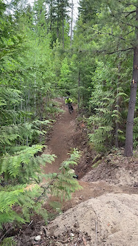
Like the song - Pub Feed is a little raw and juvenile, and may not be for everybody
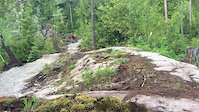
A mix of jumps, drops, and a bit of tech. It may take a few laps to get to know the lines.
Yes there are some black features - but they all are built with ride arounds or rollable options if you are a 'blue' rider.
At the bottom use ski trails to link into Greasy Jungle, climb to top of Fat Lip, or keep descending to the Rim for a full top to bottom descent.

Built by DBP Trails in 2020 - funded by the Wells Gray Community Forest.

Access Info

Shuttle up using Road 9 - at 6.5 km turn left on Rd 90 to 2.8 km.
Or pedal from Rock Lobster and up Higher Ground.

Trail Supporters
Local Trail Association
Traditionally Indigenous Territory

Recent Activity on Trail

Past Week
  • 2 rides
  • 10 miles average
6 Months
  • 17 rides
  • 10 miles avg distance
All
  • 150 rides
  • Last: Jul 4, 2026
c1c2c3c4
January
February
March
April
May
June
July
August
September
October
November
December
Status:
on Jul 2, 2026
Ideal
Avg: 4.31 (14 votes)
Your vote: 0

view (219)
close
3D
Trail Conditions
  • Unknown
  • Snow Groomed
  • Snow Packed
  • Snow Covered
  • Snow Cover Partial
  • Freeze/thaw Cycle
  • Icy
  • Prevalent Mud
  • Wet
  • Variable
  • Ideal
  • Dry
  • Very Dry
Trail Flow (Ridden Direction)
Trailforks scans users ridelogs to determine the most popular direction each trail is ridden. A good flowing trail network will have most trails flowing in a single direction according to their intension.
The colour categories are based on what percentage of riders are riding a trail in its intended direction.
  • > 96%
  • > 90%
  • > 80%
  • > 70%
  • > 50%
  • < 50%
  • bi-directional trail
  • no data
Trail Last Ridden
Trailforks scans ridelogs to determine the last time a trail was ridden.
  • < 2 days
  • < 1 week
  • < 2 weeks
  • < 1 month
  • < 6 months
  • > 6 months
Trail Ridden Direction
The intended direction a trail should be ridden.
  • Downhill Only
  • Downhill Primary
  • Both Directions
  • Uphill Primary
  • Uphill Only
  • One Direction
Contribute Details
Colors indicate trail is missing specified detail.
  • Description
  • Photos
  • Description & Photos
  • Videos
Trail Popularity ?
Trailforks scans ridelogs to determine which trails are ridden the most in the last 9 months. Trails are compared with nearby trails in the same city region with a possible 25 colour shades. Think of this as a heatmap, more rides = more kinetic energy = warmer colors.
  • most popular
  • popular
  • less popular
  • not popular
ATV/ORV/OHV Filter
Max Vehicle Width
inches
US Cell Coverage
Legend
cell carrier legend

Radar Time
Activity Recordings
Trailforks uses anonymized public activity data. ?
Activity Recordings
Trailforks uses anonymized public activity data. ?
Personal Heatmap
Activity Types
all / none
Options
2
Date range month
Winter Trails
Warning A routing network for winter maps does not exist. Selecting trails using the winter trails layer has been disabled.
Missing Trails
Most Popular
Least Popular
Trails are colored based on popularity. The more popular a trail is, the more red. Less popular trails trend towards green.
Jump Magnitude Heatmap
Heatmap of where riders jump on trails. Zoom in to see individual jumps, click circles to view jump details.
BC Backroad Status

Service Road Atlas is a free to use, community-driven service for viewing and creating reports on the numerous back-country service roads around B.C. and Alberta.

map legend
Slope Aspect
Direction the slope faces
Flat N NE E SE S SW W NW
Trails Deemphasized
Trails are shown in grey.
disable
Only show trails with no bike usage.
Enable
Suggested Layers
Based on selected activity type

    Save the current map location and zoom level as your default home location whenever this page is loaded.

    Save
        Directions to pub-feed trailhead (51.683340, -119.959270)

        Photos

        17 more »
        57 |
        Oct 17, 2024 @ 1:44pm
        Oct 17, 2024
        39 |
        Oct 17, 2024 @ 1:44pm
        Oct 17, 2024
        89 |
        Sep 30, 2022 @ 5:15pm
        Sep 30, 2022
        97 |
        Sep 30, 2022 @ 5:15pm
        Sep 30, 2022

        Videos

        2 more »
        Upper Pub Feed
        0:08 | 4 | Jun 8, 2025 , Clearwater
        0:06 | 492 | Sep 16, 2020 , Clearwater

        13 Reviews & Comments


        We hope you've been enjoying Trailforks!

        Create a FREE account to view trail comments and much more.

        • By solmountainTF Pro WGOC & contributors
        • #326177 - 2,974 views

        Frequently Asked Questions About Pub Feed

        Where is Pub Feed located?
        Pub Feed is located in Candle Creek, Clearwater, British Columbia, Canada. It is part of the Candle Creek trail network. The trailhead is located at coordinates 51.68334, -119.95927.
        How hard is Pub Feed?
        Pub Feed is rated as Black Diamond difficulty. The physical rating is Moderate. The average grade is 9.1%.
        What is the elevation gain for Pub Feed?
        Pub Feed has 12 m of elevation gain. The trail has 215 m of elevation descent. The elevation ranges from 866 m to 1,069 m.
        Is Pub Feed a point to point trail?
        Yes, Pub Feed is a point to point trail. The direction is Downhill Only. The trail type is singletrack.

        Hit the Trail

        Open in App

        Get this trail on your phone instantly.
        open trail in app

        Download Trail

        Save to wishlist, Garmin & download.
        save the trail

        Find Related Routes

        Find routes and users activities that include this trail.
        find routes for this trail

        You must enter a description before submitting.