more stats
1.7 miles
Distance
113 ft
Climb
-384 ft
Descent
00:18:28
Avg time
-270 ft
Altitude change
4,196 ft
Altitude min
4,474 ft
Altitude max
4,474 ft
Altitude start
4,203 ft
Altitude end
-3.058%
Grade
-58.832%
Grade max
121.012%
Grade min
2,243 ft
Distance climb
1 mile
Distance down
504 ft
Distance flat
00:18:28
Avg time

Red Rock Loop Details

  • Activities
    • Mountain Bike
    • Hike
    • Trail Running
  • Riding Area
    Schuerman Mountain
    Sedona, Arizona
  • Difficulty Rating
  • Local Popularity
    40 in Mountain Biking [+]
    • 5 in Trail Running
    • 20 in Hiking
  • Global Ranking
    #56521 in Mountain Biking [+]
    • #220668 in Trail Running
    • #219003 in Hiking
  • Trail Type
    Singletrack
  • Direction
    Both Directions
    Popular Direction Shown
  • Dogs Allowed
    Yes
  • eBike Allowed

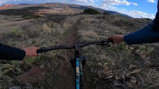
Beginner 60% and intermediate 40%, 1.69 mile MTB trail which is a bi-directional double track/singletrack that is pretty buffed the whole route. The trail tread is mostly packed dirt and slickrock. There is no preferred direction and the trail is not used that often unless you want to ride Lime Kiln or Scheurman or coming from those trails.

Trail Supporters

  • USFS
    Land Manager
Local Trail Association

Recent Activity on Trail

Past Week
  • 0 rides
  •  
6 Months
  • 8 rides
  • 29 miles avg distance
All
  • 54 rides
  • Last: Jun 23, 2026
c1c2c3c4
January
February
March
April
May
June
July
August
September
October
November
December
Status:
on Jan 11, 2025
Very Dry
Avg: 3.99 (6 votes)
Your vote: 0

view (317)
close
3D
Trail Conditions
  • Unknown
  • Snow Groomed
  • Snow Packed
  • Snow Covered
  • Snow Cover Partial
  • Freeze/thaw Cycle
  • Icy
  • Prevalent Mud
  • Wet
  • Variable
  • Ideal
  • Dry
  • Very Dry
Trail Flow (Ridden Direction)
Trailforks scans users ridelogs to determine the most popular direction each trail is ridden. A good flowing trail network will have most trails flowing in a single direction according to their intension.
The colour categories are based on what percentage of riders are riding a trail in its intended direction.
  • > 96%
  • > 90%
  • > 80%
  • > 70%
  • > 50%
  • < 50%
  • bi-directional trail
  • no data
Trail Last Ridden
Trailforks scans ridelogs to determine the last time a trail was ridden.
  • < 2 days
  • < 1 week
  • < 2 weeks
  • < 1 month
  • < 6 months
  • > 6 months
Trail Ridden Direction
The intended direction a trail should be ridden.
  • Downhill Only
  • Downhill Primary
  • Both Directions
  • Uphill Primary
  • Uphill Only
  • One Direction
Contribute Details
Colors indicate trail is missing specified detail.
  • Description
  • Photos
  • Description & Photos
  • Videos
Trail Popularity ?
Trailforks scans ridelogs to determine which trails are ridden the most in the last 9 months. Trails are compared with nearby trails in the same city region with a possible 25 colour shades. Think of this as a heatmap, more rides = more kinetic energy = warmer colors.
  • most popular
  • popular
  • less popular
  • not popular
ATV/ORV/OHV Filter
Max Vehicle Width
inches
US Cell Coverage
Legend
cell carrier legend

Radar Time
Activity Recordings
Trailforks uses anonymized public activity data. ?
Activity Recordings
Trailforks uses anonymized public activity data. ?
Personal Heatmap
Activity Types
all / none
Options
2
Date range month
Winter Trails
Warning A routing network for winter maps does not exist. Selecting trails using the winter trails layer has been disabled.
Missing Trails
Most Popular
Least Popular
Trails are colored based on popularity. The more popular a trail is, the more red. Less popular trails trend towards green.
Jump Magnitude Heatmap
Heatmap of where riders jump on trails. Zoom in to see individual jumps, click circles to view jump details.
BC Backroad Status

Service Road Atlas is a free to use, community-driven service for viewing and creating reports on the numerous back-country service roads around B.C. and Alberta.

map legend
Slope Aspect
Direction the slope faces
Flat N NE E SE S SW W NW
Trails Deemphasized
Trails are shown in grey.
disable
Only show trails with no bike usage.
Enable
Suggested Layers
Based on selected activity type

    Save the current map location and zoom level as your default home location whenever this page is loaded.

    Save
        Directions to red-rock-loop trailhead (34.849228, -111.829976)

        Photos

        6 more »
        167 |
        Jun 8, 2020 @ 12:40pm
        Jun 8, 2020
        154 |
        Jun 8, 2020 @ 12:40pm
        Jun 8, 2020
        86 |
        Jan 13, 2019 @ 4:39pm
        Jan 13, 2019
        88 |
        Jan 13, 2019 @ 4:39pm
        Jan 13, 2019

        Videos

        1 more »
        Scheurman Mountain Sedona, Arizona
        11:34 | 144 | Aug 25, 2021 , Sedona

        Routes with this trail

        16 miles 723 ft 27
        From west Sedona to Dead Horse Ranch State Park

        2 Reviews & Comments


        We hope you've been enjoying Trailforks!

        Create a FREE account to view trail comments and much more.

        • By toddTF Pro Trailforks & contributors
        • #15026 - 3,180 views

        Frequently Asked Questions About Red Rock Loop

        Where is Red Rock Loop located?
        Red Rock Loop is located in Schuerman Mountain, Sedona, Arizona, United States. It is part of the Schuerman Mountain trail network. The trailhead is located at coordinates 34.84923, -111.82998.
        How hard is Red Rock Loop?
        Red Rock Loop is rated as Blue difficulty. The average grade is 3.058%.
        What is the elevation gain for Red Rock Loop?
        Red Rock Loop has 113 ft of elevation gain. The trail has 384 ft of elevation descent. The elevation ranges from 4,196 ft to 4,474 ft.
        Is Red Rock Loop a point to point trail?
        Red Rock Loop is not a point to point trail. The direction is Both Directions. The trail type is singletrack.

        Hit the Trail

        Open in App

        Get this trail on your phone instantly.
        open trail in app

        Download Trail

        Save to wishlist, Garmin & download.
        save the trail

        Find Related Routes

        Find routes and users activities that include this trail.
        find routes for this trail

        You must enter a description before submitting.