SHAFT Details
-
Activities
- Mountain Bike
- E-Bike
-
Riding AreaMoose Mountain
Bragg Creek, Alberta -
Difficulty Rating
-
Voted DifficultyBlue (4 votes)
-
Trail TypeSingletrack
-
Bike TypeDH, AM, XC
-
DirectionDownhill OnlyPopular direction shown
-
Physical RatingModerate
-
Dogs AllowedYes
-
eBike AllowedYes up to Class 1
-
Global Ranking
-
Local Popularity85 in Mountain Biking [+]
- 80 in E-Biking
-
Year Opened2011
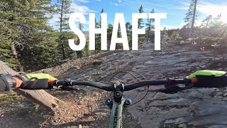
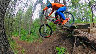
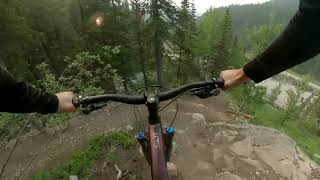
SHAFT stands for Super Happy Awesome Fun Trail. It is a high-speed bermed-corner blue trail that has become popular with the XC/AM crowd as well. SHAFT starts off fairly mellow with some sweeping corners and little hits here and there. As it rolls downhill, you get eased into faster speeds and bigger berms before getting shot out the bottom along the old T-Dub gully. Cross Canyon Creek, high-five everyone in sight with a big ol' grin on your face.
This trail is totally doable on everything in the 120-200mm travel range, including hardtails. Good tires help. Ride don't slide. Good loop options include:
- Pneuma [from Hwy66] to SHAFT and then back on the Hwy or Elbow Valley
- Sulphur Springs to Pneuma to SHAFT to EV to Pneuma to RoS [intense]
- SS to Pneuma to SHAFT to EV to Pneuma to Moosepackers to Ridgeback [hardcore!].
NB: The trail has some loose rock, but it's not like surfing a scree slope. Once you're into the bermed part of the trail, watch your crank placement - the tread has a bit of a v-notch going on and it's possible to catch a pedal on the uphill side in a few spots.
Access Info
If you're shuttling, drive to the end of the Moose mountain road and head directly west towards the gated road to the well site. Push another 100 meters up the gated road where you will find the entrance to T-Dub to your left and the entrance to SHAFT just a few meters past it, also on your left. SHAFT finishes on the last few hundred meters of T-Dub which will then flow onto the Canyon Creek road, where you pedal south (left) towards the Ing’s mine parking lot. where your driver should wait.
If you're riding up Pneuma, exit at Special K [or lower] and take the road to the well site.
Local Trail Association
-
Please consider joining or donating to the local trail association to supportdonate to earn trail karma!
trail development & maintenance.
Traditionally Indigenous Territory
More Stats for SHAFT mountain bike trail trail
-
Altitude change-1,378 ft
-
Altitude min5,099 ft
-
Altitude max6,477 ft
-
Altitude start6,477 ft
-
Altitude end5,099 ft
-
Grade-12.801%
-
Grade max-108.661%
-
Grade min7.43%
-
Distance climb1,451 ft
-
Distance down2 miles
-
Distance flat210 ft
-
Avg time00:20:28
-
Avg reverse time00:24:44
- view trail stats
- Unknown
- Snow Groomed
- Snow Packed
- Snow Covered
- Snow Cover Inadequate
- Freeze/thaw Cycle
- Icy
- Prevalent Mud
- Wet
- Variable
- Ideal
- Dry
- Very Dry
The colour categories are based on what percentage of riders are riding a trail in its intended direction.
- > 96%
- > 90%
- > 80%
- > 70%
- > 50%
- < 50%
- bi-directional trail
- no data
- < 2 days
- < 1 week
- < 2 weeks
- < 1 month
- < 6 months
- > 6 months
- Downhill Only
- Downhill Primary
- Both Directions
- Uphill Primary
- Uphill Only
- One Direction
- Description
- Photos
- Description & Photos
- Videos
- most popular
- popular
- less popular
- not popular
- mountain biking recent
- mountain biking (>6 month)
- hiking (1 year)
- moto (1 year)
- Downhill Ski
- Backcountry Ski
- Nordic Ski
- Snowmobile
Save the current map location and zoom level as your default home location whenever this page is loaded.
SaveSHAFT Trail Reports
Recent Ridelog Activity on Trail
Past Week
- 1 rides
- 16 miles avg distance
6 Months
- 229 rides
- 14 miles avg distance
All
- 2,577 rides
- Last: Jul 31, 2022
Photos
Trail Lists
-
Summer 2016
16 trails
-
2018 Shred List85 trails
Routes with this trail
8 Reviews & Comments
-
+ 3


If every region had it's own scale it would be difficult for visitors to assess and potentially unsafe.
Also, where is the 'moose mountain scale' you reference available? Is it online or posted in the area?
Just because there are more difficult trails in an area does not mean the rating system changes.
Please rate trails appropriately.
imbacanada.com/trail-difficulty-rating-system

"4. Evaluate Difficulty Relative to Local Trails
Trails should be rated relative to other trails in the region. Don’t evaluate each trail in isolation. Consider all the trails in a region and how they compare to one another. This will help you rank the relative difficulty of each trail and will help trail users select an appropriate route. Trails will rate differently from region to region. A black diamond trail in one region may rate as a blue square in another region, but the ratings should be consistent locally."

Loamzilla- red (1 black option)
Pistolero - red (streeps)
Sidetrax - red (semi steeps)
Shaft - red (physical with loose rocks)
Race of spades - red (physical) with black options
Flow - blue
Shoulda - blue
Merlin - very blue
There’s the same issues in BC ,they have blues that would be black anywhere else
www.britishcycling.org.uk/search/article/mtbst20100615-MTB-Trail-Grading-System-0

Videos
Nearby Trails
- T-dub 56 ft
- T-dub Alt Entrance 728 ft
- Moose Mountain Trail 1,332 ft
- T-dub Gully Line 1,608 ft
- Moose Road To Special K / Pneuma Connector 3,146 ft
- embed SHAFT trail on your website
- By brenthillier
NSMBA TRAILFORKS & contributors
- #4223 - 13,576 views
- subscribe
- login to download gpx or kml files.