more stats
1.6 miles
Distance
-1,454 ft
Descent
00:18:57
Avg time
-1,455 ft
Altitude change
5,027 ft
Altitude min
6,482 ft
Altitude max
6,482 ft
Altitude start
5,026 ft
Altitude end
-17.4%
Grade
-86.9%
Grade max
-2.9%
Grade min
2 miles
Distance down
00:18:57
Avg time

T-Dub Details

  • Activities
    • Mountain Bike
    • E-Bike
  • Riding Area
    Moose Mountain
    Bragg Creek, Alberta
  • Difficulty Rating
  • Voted Difficulty
    Black Diamond (2 votes)
  • Local Popularity
    90 in Mountain Biking [+]
    • 100 in E-Biking
  • Global Ranking
    #1124 in Mountain Biking [+]
    • #10962 in E-Biking
  • Trail Type
    Singletrack
  • Bike Type
    DH
  • Dogs Allowed
    Yes
  • eBike Allowed
    Yes up to Class 1
  • TTFs on Trail
    Bridge, Jump

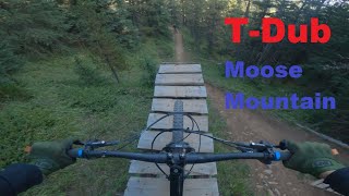
T-Dub is a shuttle/downhill trail accessed after a very brief pedal at the end of the Moose Mountain road. The trail has many technical features, both natural and man made. These range from small booters to a large whale-tail canyon gap on the lower portion of the trail. The trail ends at Canyon Creek, requiring a pedal back to the Ing Mine parking lot.

The trail offers a variety of sections that makes it a lot of fun to ride over and over again.

Local Trail Association

Recent Activity on Trail

Past Week
  • 6 rides
  • 17.1 km average
6 Months
  • 30 rides
  • 21.1 km avg distance
All
  • 598 rides
  • Last: Jun 27, 2026
c1c2c3c4
January
February
March
April
May
June
July
August
September
October
November
December
update trails status or condition

T-Dub Trail Reports

statusdatedescription
May 15, 2026 @ 12:53pm (America/Creston)
May 15, 2026
Nov 17, 2025 @ 3:26pm (America/Edmonton)
Nov 17, 2025
TDub is running well except for a few areas where some persistent moisture has covered roots and rocks making those areas quite slick and loose,...
Nov 8, 2025 @ 11:44am (America/Creston)
Nov 8, 2025
Oct 25, 2025 @ 12:08pm (America/Creston)
Oct 25, 2025
Sep 27, 2025 @ 11:59am (America/Creston)
Sep 27, 2025
more »
Status:
on May 15, 2026
Ideal
Avg: 4.63 (58 votes)
Your vote: 0

view (4,501)
close
3D
Trail Conditions
  • Unknown
  • Snow Groomed
  • Snow Packed
  • Snow Covered
  • Snow Cover Partial
  • Freeze/thaw Cycle
  • Icy
  • Prevalent Mud
  • Wet
  • Variable
  • Ideal
  • Dry
  • Very Dry
Trail Flow (Ridden Direction)
Trailforks scans users ridelogs to determine the most popular direction each trail is ridden. A good flowing trail network will have most trails flowing in a single direction according to their intension.
The colour categories are based on what percentage of riders are riding a trail in its intended direction.
  • > 96%
  • > 90%
  • > 80%
  • > 70%
  • > 50%
  • < 50%
  • bi-directional trail
  • no data
Trail Last Ridden
Trailforks scans ridelogs to determine the last time a trail was ridden.
  • < 2 days
  • < 1 week
  • < 2 weeks
  • < 1 month
  • < 6 months
  • > 6 months
Trail Ridden Direction
The intended direction a trail should be ridden.
  • Downhill Only
  • Downhill Primary
  • Both Directions
  • Uphill Primary
  • Uphill Only
  • One Direction
Contribute Details
Colors indicate trail is missing specified detail.
  • Description
  • Photos
  • Description & Photos
  • Videos
Trail Popularity ?
Trailforks scans ridelogs to determine which trails are ridden the most in the last 9 months. Trails are compared with nearby trails in the same city region with a possible 25 colour shades. Think of this as a heatmap, more rides = more kinetic energy = warmer colors.
  • most popular
  • popular
  • less popular
  • not popular
ATV/ORV/OHV Filter
Max Vehicle Width
inches
US Cell Coverage
Legend
cell carrier legend

Radar Time
Activity Recordings
Trailforks uses anonymized public activity data. ?
Activity Recordings
Trailforks uses anonymized public activity data. ?
Personal Heatmap
Activity Types
all / none
Options
2
Date range month
Winter Trails
Warning A routing network for winter maps does not exist. Selecting trails using the winter trails layer has been disabled.
Missing Trails
Most Popular
Least Popular
Trails are colored based on popularity. The more popular a trail is, the more red. Less popular trails trend towards green.
Jump Magnitude Heatmap
Heatmap of where riders jump on trails. Zoom in to see individual jumps, click circles to view jump details.
BC Backroad Status

Service Road Atlas is a free to use, community-driven service for viewing and creating reports on the numerous back-country service roads around B.C. and Alberta.

map legend
Slope Aspect
Direction the slope faces
Flat N NE E SE S SW W NW
Trails Deemphasized
Trails are shown in grey.
disable
Only show trails with no bike usage.
Enable
Suggested Layers
Based on selected activity type

    Save the current map location and zoom level as your default home location whenever this page is loaded.

    Save
        Directions to tdub trailhead (50.914020, -114.778870)

        Photos

        98 more »
        1,508 |
        Oct 24, 2017 @ 4:46pm
        Oct 24, 2017
        1,450 |
        Aug 24, 2016 @ 11:13am
        Aug 24, 2016
        59 |
        Nov 27, 2023 @ 3:14pm
        Nov 27, 2023
        59 |
        Nov 27, 2023 @ 3:13pm
        Nov 27, 2023

        Videos

        59 more »
        youtuber The Feature That Broke the Curse?
        12:28 | 1788 | Sep 3, 2020 , Bragg Creek
        youtuber T Dub Step Up by Ryan
        0:05 | 81 | Sep 30, 2025 , Bragg Creek
        T-Dub [Moose Mountain]
        11:11 | 416 | Nov 10, 2023 , Bragg Creek
        T-Dub (Moose Mountain AB)
        7:00 | 733 | Sep 22, 2022 , Bragg Creek

        Trail Lists

        Routes with this trail

        4.0 13 miles 2,351 ft 6 Loop
        Go all the way up to the end of . Take the access road down to where it meets up with . The end of meets...
        10 miles 1,739 ft 2 Loop
        Route for map overview of corporate sponsored trail day.
        63 miles 8,562 ft 33
        All day epic adventure ride, Bragg to Canmore, or Canmore to Bragg. Rideable after mid June on a typical...

        12 Reviews & Comments


        We hope you've been enjoying Trailforks!

        Create a FREE account to view trail comments and much more.

        Frequently Asked Questions About T-Dub

        Where is T-Dub located?
        T-Dub is located in Moose Mountain, Bragg Creek, Alberta, Canada. It is part of the Moose Mountain trail network. The trailhead is located at coordinates 50.91402, -114.77887.
        How hard is T-Dub?
        T-Dub is rated as Black Diamond difficulty. The average grade is 17.4%.
        What is the elevation gain for T-Dub?
        The trail has 1,454 ft of elevation descent. The elevation ranges from 5,027 ft to 6,482 ft.
        How long is T-Dub?
        T-Dub is 1.6 miles long. The trail type is singletrack.

        Hit the Trail

        Open in App

        Get this trail on your phone instantly.
        open trail in app

        Download Trail

        Save to wishlist, Garmin & download.
        save the trail

        Find Related Routes

        Find routes and users activities that include this trail.
        find routes for this trail

        You must enter a description before submitting.