more stats
879 ft
Distance
95 ft
Climb
-13 ft
Descent
00:02:17
Avg time
82 ft
Altitude change
484 ft
Altitude min
567 ft
Altitude max
484 ft
Altitude start
568 ft
Altitude end
9.4%
Grade
-13.6%
Grade max
22.6%
Grade min
682 ft
Distance climb
112 ft
Distance down
85 ft
Distance flat
00:02:17
Avg time

Skull Details

  • Activities
    • Mountain Bike
    • E-Bike
    • Hike
    • Trail Running
  • Riding Area
    Hartland Mountain Bike Park
    Victoria, British Columbia
  • Difficulty Rating
  • Voted Difficulty
    Blue (6 votes)
  • Local Popularity
    100 in Mountain Biking [+]
    • 100 in E-Biking
    • 95 in Trail Running
    • 95 in Hiking
  • Global Ranking
    #508 in Mountain Biking [+]
    • #1948 in E-Biking
    • #532 in Trail Running
    • #1543 in Hiking
  • Trail Type
    Singletrack
  • Bike Type
    AM, XC
  • Direction
    Both Directions
  • Climb Difficulty
    Blue
  • Physical Rating
    Hard
  • Trail Visibility
    Always easy to follow
  • Dogs Allowed
    Yes
  • eBike Allowed
    Yes up to Class 1
  • TTFs on Trail
    Berm, Jump
  • Ride in Rain
    Yes
  • Land Owner
    Capital Regional District

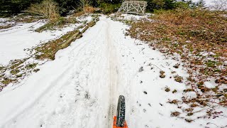
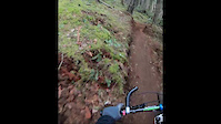
A short climb to start your ride, or a fun downhill to end it.

Substantially rerouted in 2018 by the SIMBS trail crew, to move the trail out of a seasonal watercourse.

Trail Supporters
  • SIMBS
    Maintainer
  • Original: Dave Bissenden, Boyd McIvor
    Builder
Local Trail Association
Traditionally Indigenous Territory

Recent Activity on Trail

Past Week
  • 90 rides
  • 11.5 km average
6 Months
  • 2,551 rides
  • 11.0 km avg distance
All
  • 19,684 rides
  • Last: Jun 27, 2026
c1c2c3c4
January
February
March
April
May
June
July
August
September
October
November
December
Status:
on Jun 14, 2026
Dry
Avg: 4.02 (40 votes)
Your vote: 0

view (81,780)
close
3D
Trail Conditions
  • Unknown
  • Snow Groomed
  • Snow Packed
  • Snow Covered
  • Snow Cover Partial
  • Freeze/thaw Cycle
  • Icy
  • Prevalent Mud
  • Wet
  • Variable
  • Ideal
  • Dry
  • Very Dry
Trail Flow (Ridden Direction)
Trailforks scans users ridelogs to determine the most popular direction each trail is ridden. A good flowing trail network will have most trails flowing in a single direction according to their intension.
The colour categories are based on what percentage of riders are riding a trail in its intended direction.
  • > 96%
  • > 90%
  • > 80%
  • > 70%
  • > 50%
  • < 50%
  • bi-directional trail
  • no data
Trail Last Ridden
Trailforks scans ridelogs to determine the last time a trail was ridden.
  • < 2 days
  • < 1 week
  • < 2 weeks
  • < 1 month
  • < 6 months
  • > 6 months
Trail Ridden Direction
The intended direction a trail should be ridden.
  • Downhill Only
  • Downhill Primary
  • Both Directions
  • Uphill Primary
  • Uphill Only
  • One Direction
Contribute Details
Colors indicate trail is missing specified detail.
  • Description
  • Photos
  • Description & Photos
  • Videos
Trail Popularity ?
Trailforks scans ridelogs to determine which trails are ridden the most in the last 9 months. Trails are compared with nearby trails in the same city region with a possible 25 colour shades. Think of this as a heatmap, more rides = more kinetic energy = warmer colors.
  • most popular
  • popular
  • less popular
  • not popular
ATV/ORV/OHV Filter
Max Vehicle Width
inches
US Cell Coverage
Legend
cell carrier legend

Radar Time
Activity Recordings
Trailforks uses anonymized public activity data. ?
Activity Recordings
Trailforks uses anonymized public activity data. ?
Personal Heatmap
Activity Types
all / none
Options
2
Date range month
Winter Trails
Warning A routing network for winter maps does not exist. Selecting trails using the winter trails layer has been disabled.
Missing Trails
Most Popular
Least Popular
Trails are colored based on popularity. The more popular a trail is, the more red. Less popular trails trend towards green.
Jump Magnitude Heatmap
Heatmap of where riders jump on trails. Zoom in to see individual jumps, click circles to view jump details.
BC Backroad Status

Service Road Atlas is a free to use, community-driven service for viewing and creating reports on the numerous back-country service roads around B.C. and Alberta.

map legend
Slope Aspect
Direction the slope faces
Flat N NE E SE S SW W NW
Trails Deemphasized
Trails are shown in grey.
disable
Only show trails with no bike usage.
Enable
Suggested Layers
Based on selected activity type

    Save the current map location and zoom level as your default home location whenever this page is loaded.

    Save
        Directions to skull trailhead (48.529800, -123.459210)

        Photos

        17 more »
        405 |
        Jun 11, 2018 @ 7:27pm
        Jun 11, 2018
        168 |
        Jun 14, 2020 @ 4:56pm
        Jun 14, 2020
        194 |
        Jun 11, 2018 @ 7:28pm
        Jun 11, 2018
        258 |
        Jun 5, 2018 @ 1:39pm
        Jun 5, 2018

        Videos

        9 more »
        youtuber MTB Riding Hartland Trails, Victoria on...
        10:39 | 59 | Sep 23, 2025 , Victoria
        Feb 9th, 2025 Snow
        2:52 | 81 | Feb 9, 2025 , Victoria
        Skull at the Hartland Bike Park, Saanich, BC
        2:43 | 168 | Nov 3, 2023 , Victoria
        190311 Skull 2019
        0:35 | 350 | Mar 11, 2019 , Victoria

        Routes with this trail

        5.0 6 miles 1,087 ft 13
        This loop suggestion is part of our Community Routes—a group of routes created by the community, for the...
        4.0 3 miles 684 ft 9 Loop
        Looking for some Hartland tech? Here's a favourite loop of mine that takes you up and over to Hot Cherry...
        3.7 8 miles 1,160 ft 22
        So much fun. Tech singletrack bookmarked by steep fire road climbs

        6 Reviews & Comments


        We hope you've been enjoying Trailforks!

        Create a FREE account to view trail comments and much more.

        • By KZ-Powned & contributors
        • #1133 - 8,916 views

        Frequently Asked Questions About Skull

        Where is Skull located?
        Skull is located in Hartland Mountain Bike Park, Victoria, British Columbia, Canada. It is part of the Hartland Mountain Bike Park trail network. The trailhead is located at coordinates 48.5298, -123.45921.
        How hard is Skull?
        Skull is rated as Blue difficulty. The physical rating is Hard. The average grade is 9.4%. The climb difficulty is rated Blue.
        What is the elevation gain for Skull?
        Skull has 95 ft of elevation gain. The trail has 13 ft of elevation descent. The elevation ranges from 484 ft to 567 ft.
        Is Skull a point to point trail?
        Skull is not a point to point trail. The direction is Both Directions. The trail type is singletrack.

        Hit the Trail

        Open in App

        Get this trail on your phone instantly.
        open trail in app

        Download Trail

        Save to wishlist, Garmin & download.
        save the trail

        Find Related Routes

        Find routes and users activities that include this trail.
        find routes for this trail

        You must enter a description before submitting.