more stats
4,188 ft
Distance
56 ft
Climb
-67 ft
Descent
00:12:07
Avg time
-10 ft
Altitude change
2,112 ft
Altitude min
2,164 ft
Altitude max
2,122 ft
Altitude start
2,112 ft
Altitude end
-0.234%
Grade
-21.353%
Grade max
28.331%
Grade min
1,245 ft
Distance climb
1,578 ft
Distance down
1,305 ft
Distance flat
00:12:07
Avg time

Tech Loop Details

  • Activities
    • Mountain Bike
    • E-Bike
    • Hike
    • Trail Running
  • Riding Area
    Gold Canyon
    , Arizona
  • Difficulty Rating
  • Voted Difficulty
    Black Diamond (1 vote)
  • Local Popularity
    85 in Mountain Biking [+]
    • 75 in E-Biking
    • 5 in Trail Running
    • 65 in Hiking
  • Global Ranking
    #7293 in Mountain Biking [+]
    • #17671 in E-Biking
    • #136263 in Trail Running
    • #81714 in Hiking
  • Trail Type
    Singletrack
  • Bike Type
    XC
  • Direction
    Both Directions
    Popular Direction Shown
  • Climb Difficulty
    Black Diamond
  • Physical Rating
    Moderate
  • Dogs Allowed
    Yes
  • eBike Allowed
    Yes up to Class 1
  • TTFs on Trail
    Drop, Rock Face

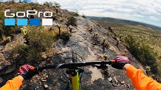
Test your rock skillz on the Tech Loop. Follow the white dots....if you're able. It's not a race, so take your time and session a few of the more difficult sections. Some have multiple lines, so try a few.

For maximum fun, only ride counter-clockwise.

Local Trail Association
Traditionally Indigenous Territory

Recent Activity on Trail

Past Week
  • 0 rides
  •  
6 Months
  • 38 rides
  • 14 miles avg distance
All
  • 469 rides
  • Last: May 27, 2026
c1c2c3c4
January
February
March
April
May
June
July
August
September
October
November
December
update trails status or condition

Tech Loop Trail Reports

statusdatedescription
Feb 8, 2026 @ 9:05am (America/Phoenix)
Feb 8, 2026
Fun little side trail, watch out for cacti
Dec 13, 2025 @ 9:32am (America/Phoenix)
Dec 13, 2025
Nov 4, 2025 @ 9:54am (America/Phoenix)
Nov 4, 2025
Significant uphill rut from the Monsoons. Just before the tech starts. It's very loose and deep... maybe a hike a bike until repaired.
Dec 29, 2024 @ 12:10pm
Dec 29, 2024
Mostly easy trail overall with enough rock gardens and lifts/drops to get a black rating. Fun overall!
Nov 10, 2024 @ 10:26am
Nov 10, 2024
more »
Status:
on Feb 8, 2026
Ideal
Avg: 4.17 (12 votes)
Your vote: 0

view (1,993)
close
3D
Trail Conditions
  • Unknown
  • Snow Groomed
  • Snow Packed
  • Snow Covered
  • Snow Cover Partial
  • Freeze/thaw Cycle
  • Icy
  • Prevalent Mud
  • Wet
  • Variable
  • Ideal
  • Dry
  • Very Dry
Trail Flow (Ridden Direction)
Trailforks scans users ridelogs to determine the most popular direction each trail is ridden. A good flowing trail network will have most trails flowing in a single direction according to their intension.
The colour categories are based on what percentage of riders are riding a trail in its intended direction.
  • > 96%
  • > 90%
  • > 80%
  • > 70%
  • > 50%
  • < 50%
  • bi-directional trail
  • no data
Trail Last Ridden
Trailforks scans ridelogs to determine the last time a trail was ridden.
  • < 2 days
  • < 1 week
  • < 2 weeks
  • < 1 month
  • < 6 months
  • > 6 months
Trail Ridden Direction
The intended direction a trail should be ridden.
  • Downhill Only
  • Downhill Primary
  • Both Directions
  • Uphill Primary
  • Uphill Only
  • One Direction
Contribute Details
Colors indicate trail is missing specified detail.
  • Description
  • Photos
  • Description & Photos
  • Videos
Trail Popularity ?
Trailforks scans ridelogs to determine which trails are ridden the most in the last 9 months. Trails are compared with nearby trails in the same city region with a possible 25 colour shades. Think of this as a heatmap, more rides = more kinetic energy = warmer colors.
  • most popular
  • popular
  • less popular
  • not popular
ATV/ORV/OHV Filter
Max Vehicle Width
inches
US Cell Coverage
Legend
cell carrier legend

Radar Time
Activity Recordings
Trailforks uses anonymized public activity data. ?
Activity Recordings
Trailforks uses anonymized public activity data. ?
Personal Heatmap
Activity Types
all / none
Options
2
Date range month
Winter Trails
Warning A routing network for winter maps does not exist. Selecting trails using the winter trails layer has been disabled.
Missing Trails
Most Popular
Least Popular
Trails are colored based on popularity. The more popular a trail is, the more red. Less popular trails trend towards green.
Jump Magnitude Heatmap
Heatmap of where riders jump on trails. Zoom in to see individual jumps, click circles to view jump details.
BC Backroad Status

Service Road Atlas is a free to use, community-driven service for viewing and creating reports on the numerous back-country service roads around B.C. and Alberta.

map legend
Slope Aspect
Direction the slope faces
Flat N NE E SE S SW W NW
Trails Deemphasized
Trails are shown in grey.
disable
Only show trails with no bike usage.
Enable
Suggested Layers
Based on selected activity type

    Save the current map location and zoom level as your default home location whenever this page is loaded.

    Save
        Directions to tech-loop trailhead (33.381430, -111.393000)

        Photos

        4 more »
        278 |
        Dec 30, 2017 @ 7:02am
        Dec 30, 2017
        243 |
        Dec 30, 2017 @ 7:02am
        Dec 30, 2017
        510 |
        Jan 3, 2013 @ 12:17pm
        Jan 3, 2013
        589 |
        Jan 3, 2013 @ 12:18pm
        Jan 3, 2013

        Videos

        2 more »
        Finding some MTB Gold in Gold Canyon,...
        8:24 | 284 | Feb 23, 2021 , Gold Canyon
        Gold Canyon, AZ | Cacti and blood and SkyNet!...
        4:52 | 348 | Jan 12, 2020 , Gold Canyon

        Routes with this trail

        4.2 13 miles 1,188 ft 11
        Do Hoodoo and Cajones, then the rest of the stuff. Finish off with before heading out.
        4.0 30 miles 2,771 ft 56 Loop
        This is a route showcasing all of the technical trails in the trail system with the exception of portions...
        5.0 13 miles 1,106 ft 25 Loop
        Clockwise loop from the parking lot. You can check out if you want. Also can skip Jodi's Dream, and...

        2 Reviews & Comments


        We hope you've been enjoying Trailforks!

        Create a FREE account to view trail comments and much more.

        Nearby Trails

        • By toddTF Pro Trailforks & contributors
        • #15305 - 2,509 views

        Frequently Asked Questions About Tech Loop

        Where is Tech Loop located?
        Tech Loop is located in Gold Canyon, Arizona, United States. It is part of the Gold Canyon trail network. The trailhead is located at coordinates 33.38143, -111.393.
        How hard is Tech Loop?
        Tech Loop is rated as Black Diamond difficulty. The physical rating is Moderate. The average grade is 0.234%. The climb difficulty is rated Black Diamond.
        What is the elevation gain for Tech Loop?
        Tech Loop has 17 m of elevation gain. The trail has 20 m of elevation descent. The elevation ranges from 644 m to 660 m.
        Is Tech Loop a point to point trail?
        Tech Loop is not a point to point trail. The direction is Both Directions. The trail type is singletrack.

        Hit the Trail

        Open in App

        Get this trail on your phone instantly.
        open trail in app

        Download Trail

        Save to wishlist, Garmin & download.
        save the trail

        Find Related Routes

        Find routes and users activities that include this trail.
        find routes for this trail

        You must enter a description before submitting.