more stats
1.8 miles
Distance
192 ft
Climb
-185 ft
Descent
00:18:05
Avg time
8 ft
Altitude change
774 ft
Altitude min
845 ft
Altitude max
837 ft
Altitude start
846 ft
Altitude end
0.1%
Grade
-20.9%
Grade max
15.7%
Grade min
3,550 ft
Distance climb
3,432 ft
Distance down
2,428 ft
Distance flat
00:18:05
Avg time

Technical Trail Details

  • Activities
    • Mountain Bike
    • Winter Fat Bike
    • Hike
    • Trail Running
  • Riding Area
    East Fork State Park
    Bethel, Ohio
  • AKA
    P3 or Tek Trail
  • Difficulty Rating
  • Voted Difficulty
    Black Diamond (1 vote)
  • Local Popularity
    95 in Mountain Biking [+]
    • 95 in Trail Running
    • 100 in Hiking
  • Global Ranking
    #119742 in Mountain Biking [+]
    • #47245 in Trail Running
    • #48216 in Hiking
  • Trail Type
    Singletrack
  • Bike Type
    XC, Fat
  • Direction
    Both Directions
  • Climb Difficulty
    Blue
  • Physical Rating
    Hard
  • Dogs Allowed
    Yes
  • Land Owner
    Ohio State Parks

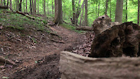
The technical trail has more features to practice your skills on with creek crossings, natural rideovers and rooty sections. It is also the connector between the Intermediate Trail (P2) and the Lakeside Trail. It can be accessed from the gravel lot via the connector trail or from the Deer Run parking lot.

Local Trail Association

Recent Activity on Trail

Past Week
  • 0 rides
  •  
6 Months
  • 21 rides
  • 14 miles avg distance
All
  • 101 rides
  • Last: Jun 25, 2026
c1c2c3c4
January
February
March
April
May
June
July
August
September
October
November
December
update trails status or condition

Technical Trail Trail Reports

Status:
on Sep 14, 2025
Dry
no votes yet
Your vote: 0

view (838)
close
3D
Trail Conditions
  • Unknown
  • Snow Groomed
  • Snow Packed
  • Snow Covered
  • Snow Cover Partial
  • Freeze/thaw Cycle
  • Icy
  • Prevalent Mud
  • Wet
  • Variable
  • Ideal
  • Dry
  • Very Dry
Trail Flow (Ridden Direction)
Trailforks scans users ridelogs to determine the most popular direction each trail is ridden. A good flowing trail network will have most trails flowing in a single direction according to their intension.
The colour categories are based on what percentage of riders are riding a trail in its intended direction.
  • > 96%
  • > 90%
  • > 80%
  • > 70%
  • > 50%
  • < 50%
  • bi-directional trail
  • no data
Trail Last Ridden
Trailforks scans ridelogs to determine the last time a trail was ridden.
  • < 2 days
  • < 1 week
  • < 2 weeks
  • < 1 month
  • < 6 months
  • > 6 months
Trail Ridden Direction
The intended direction a trail should be ridden.
  • Downhill Only
  • Downhill Primary
  • Both Directions
  • Uphill Primary
  • Uphill Only
  • One Direction
Contribute Details
Colors indicate trail is missing specified detail.
  • Description
  • Photos
  • Description & Photos
  • Videos
Trail Popularity ?
Trailforks scans ridelogs to determine which trails are ridden the most in the last 9 months. Trails are compared with nearby trails in the same city region with a possible 25 colour shades. Think of this as a heatmap, more rides = more kinetic energy = warmer colors.
  • most popular
  • popular
  • less popular
  • not popular
ATV/ORV/OHV Filter
Max Vehicle Width
inches
US Cell Coverage
Legend
cell carrier legend

Radar Time
Activity Recordings
Trailforks uses anonymized public activity data. ?
Activity Recordings
Trailforks uses anonymized public activity data. ?
Personal Heatmap
Activity Types
all / none
Options
2
Date range month
Winter Trails
Warning A routing network for winter maps does not exist. Selecting trails using the winter trails layer has been disabled.
Missing Trails
Most Popular
Least Popular
Trails are colored based on popularity. The more popular a trail is, the more red. Less popular trails trend towards green.
Jump Magnitude Heatmap
Heatmap of where riders jump on trails. Zoom in to see individual jumps, click circles to view jump details.
BC Backroad Status

Service Road Atlas is a free to use, community-driven service for viewing and creating reports on the numerous back-country service roads around B.C. and Alberta.

map legend
Slope Aspect
Direction the slope faces
Flat N NE E SE S SW W NW
Trails Deemphasized
Trails are shown in grey.
disable
Only show trails with no bike usage.
Enable
Suggested Layers
Based on selected activity type

    Save the current map location and zoom level as your default home location whenever this page is loaded.

    Save
        Directions to technical-trail trailhead (39.009530, -84.142580)

        Photos

        6 more »
        166 |
        Feb 14, 2021 @ 10:42am
        Feb 14, 2021
        198 |
        Feb 14, 2021 @ 10:32am
        Feb 14, 2021
        127 |
        Jun 8, 2020 @ 5:12pm
        Jun 8, 2020
        135 |
        Jun 8, 2020 @ 5:10pm
        Jun 8, 2020

        Videos

        1 more »
        0:08 | | Feb 14, 2021 , Bethel

        Routes with this trail

        10 miles 469 ft 5
        Ameens route to knock out East Fork

        Reviews / Comments

        No reviews yet, be the first to write a review or ask a question.
        Use trail reports to comment on trail conditions.


        We hope you've been enjoying Trailforks!

        Create a FREE account to view trail comments and much more.

        • By clovercreekelmo & contributors
        • #31015 - 2,928 views

        Frequently Asked Questions About Technical Trail

        Where is Technical Trail located?
        Technical Trail is located in East Fork State Park, Bethel, Ohio, United States. It is part of the East Fork State Park trail network. The trailhead is located at coordinates 39.00953, -84.14258.
        How hard is Technical Trail?
        Technical Trail is rated as Blue difficulty. The physical rating is Hard. The average grade is 0.1%. The climb difficulty is rated Blue.
        What is the elevation gain for Technical Trail?
        Technical Trail has 192 ft of elevation gain. The trail has 185 ft of elevation descent. The elevation ranges from 774 ft to 845 ft.
        Is Technical Trail a point to point trail?
        Technical Trail is not a point to point trail. The direction is Both Directions. The trail type is singletrack.

        Hit the Trail

        Open in App

        Get this trail on your phone instantly.
        open trail in app

        Download Trail

        Save to wishlist, Garmin & download.
        save the trail

        Find Related Routes

        Find routes and users activities that include this trail.
        find routes for this trail

        You must enter a description before submitting.