2 miles
Distance
14 ft
Climb
-1,124 ft
Descent
00:19:16
Avg time
Trail Supporters, Builders & Maintainers of Third Divide Trail
USFSLand Manager
Third Divide Details
-
Activities
- Mountain Bike
- E-Bike
- Hike
- Trail Running
- Horse
- Dirtbike
-
Riding AreaDownieville
, California -
Ref Number#11E07
-
Difficulty Rating
-
Hiking SAC ScaleT1 Hiking
-
Trail TypeSingletrack
-
Bike TypeAM, XC
-
Trail UsageMulti-use
-
DirectionDownhill PrimaryPopular direction shown
-
Physical RatingModerate
-
Trail VisibilityAlways easy to follow
-
SeasonSpring, Summer, Fall
-
Dogs AllowedYes
-
eBike Allowed
-
Global Ranking#247 in Mountain Biking
-
Local Popularity100 in Mountain Biking [+]
- 100 in E-Biking
- 85 in Trail Running
- 90 in Hiking
- 100 in Dirtbiking
- 5 in Horseback
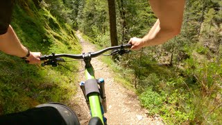
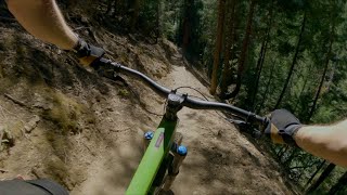
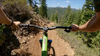
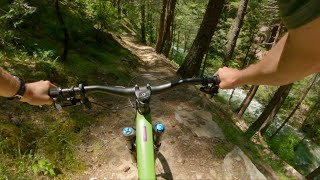
Third Divide makes up part of the classic Downieville downhill route. It is considered the "fast and flowy" section--quite a bit smoother overall than Butcher Ranch with a great downhill pitch. It is typically maintained at a high level due to its popularity and use.
Access Info
After crossing Pauley Creek on Butcher Ranch trail and climbing out of the valley, the trail will split, with Third Divide continuing uphill to the right, and Second Divide splitting off left and down. The top of Third Divide and also be accessed from Big Boulder trail from the north.
Local Trail Association
-
Please consider joining or donating to the local trail association to supportdonate to earn trail karma!
trail development & maintenance.
Traditionally Indigenous Territory
More Stats for Third Divide mountain bike trail trail
-
Altitude change-1,110 ft
-
Altitude min3,516 ft
-
Altitude max4,640 ft
-
Altitude start4,626 ft
-
Altitude end3,517 ft
-
Grade-10.1%
-
Grade max-54.9%
-
Grade min10%
-
Distance climb505 ft
-
Distance down2 miles
-
Distance flat128 ft
-
Avg time00:19:16
-
Avg reverse time00:45:50
- view trail stats
close
Trail Conditions
- Unknown
- Snow Groomed
- Snow Packed
- Snow Covered
- Freeze/thaw Cycle
- Icy
- Prevalent Mud
- Wet
- Variable
- Ideal
- Dry
- Very Dry
Trail Ridden Direction
Trailforks scans users ridelogs to determine the most popular direction each trail is ridden. A good flowing trail network will have most trails flowing in a single direction according to their intension.
The colour categories are based on what percentage of riders are riding a trail in its intended direction.
- > 96%
- > 90%
- > 80%
- > 70%
- > 50%
- < 50%
Trail Last Ridden
Trailforks scans ridelogs to determine the last time a trail was ridden.
- < 2 days
- < 1 week
- < 2 weeks
- < 1 month
- < 6 months
- > 6 months
Trail Ridden Direction
The intended direction a trail should be ridden.
- Downhill Only
- Downhill Primary
- Both Directions
- Uphill Primary
- Uphill Only
- One Direction
ContributeDetails
Colors indicate trail is missing specified detail.
- Description
- Photos
- Description & Photos
- Videos
Trail Popularity ?
Trailforks scans ridelogs to determine which trails are ridden the most in the last 9 months.
Trails are compared with nearby trails in the same city region with a possible 25 colour shades.
Think of this as a heatmap, more rides = more kinetic energy = warmer colors.
- most popular
- popular
- less popular
- not popular
ATV/ORV/OHV Filter
Max Vehicle Width
inches
Radar Time
LEGEND
Trail Difficulties
Trail Report Status
- Access Road/Trail
- White
- Green
- Blue
- Black
- Double Black Diamond
Trail Report Status
- Clear / Green
- Minor Issue / Yellow
- Significant Issue / Amber
- Closed
- Land Owner Overlay
- Wilderness (typically no bikes in USA)
- BLM (public)
- USFS (Wildlife sanctuaries darker than usfs)
- State land
- Indigenous
- Military
Trail Conditions
- Unknown
- Snow Groomed
- Snow Packed
- Snow Covered
- Freeze/thaw Cycle
- Icy
- Prevalent Mud
- Wet
- Variable
- Ideal
- Dry
- Very Dry
- Map Markers
Trail Head
Photo
Directory Listing
Riding Area
TTF
Parking
Viewpoint
Information
Warning
Directions
Sight
Restrooms
eBike Charging Point
Water Fountain/Source
Gate
Trail Sign
Table or Bench
Ladder
Stairs
Bridge
Boardwalk
Camping
Cabin
Lodge
Bear Cache
Dock
Ranger Station
Summit
Other
Directions to third-divide trailhead
(39.611840, -120.750730)
update trails status or condition
Third Divide Trail Reports
view all reports »
Recent Ridelog Activity on Trail
Past Week
- 0 rides
6 Months
- 225 rides
- 17 miles avg distance
All
- 3,275 rides
Videos
more »
Nearby Trails
- Second Divide 0 ft
- Red Oak Ohv Trail (lower) 2 miles
- Mine Shaft Singletrack 2 miles
- Big Boulder 3 miles
- Lavezzola Road 3 miles
- embed Third Divide trail on your website
- By FRguild & contributors
- #7534 - 4,780 views
- subscribe
- login to download gpx or kml files.
Open trail in mobile app
Use this guide to help plan your next trip to Downieville! twowheeledwanderer.com/posts/a-quick-mountain-bike-escape-to-downieville-california