more stats
764 ft
Distance
21 ft
Climb
00:01:48
Avg time
22 ft
Altitude change
445 ft
Altitude min
467 ft
Altitude max
445 ft
Altitude start
466 ft
Altitude end
2.8%
Grade
-2.2%
Grade max
8.1%
Grade min
367 ft
Distance climb
36 ft
Distance down
361 ft
Distance flat
00:01:48
Avg time

Two Trees Details

  • Activities
    • Mountain Bike
    • E-Bike
    • Hike
    • Trail Running
  • Riding Area
    Hartland Mountain Bike Park
    Victoria, British Columbia
  • Difficulty Rating
  • Voted Difficulty
    Blue (1 vote)
  • Local Popularity
    100 in Mountain Biking [+]
    • 95 in E-Biking
    • 85 in Trail Running
    • 80 in Hiking
  • Global Ranking
    #43796 in Mountain Biking [+]
    • #24371 in E-Biking
    • #50837 in Trail Running
    • #64646 in Hiking
  • Trail Type
    Singletrack
  • Bike Type
    AM, XC
  • Direction
    Both Directions
  • Climb Difficulty
    Blue
  • Physical Rating
    Moderate
  • Trail Visibility
    Always easy to follow
  • Dogs Allowed
    Yes
  • eBike Allowed
  • TTFs on Trail
    Rock Garden
  • Ride in Rain
    Yes
  • Land Owner
    Capital Regional District

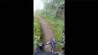
Two trees provides an alternative to a short section of Second Ave. It features exposed bedrock and a few tricky rock sections which put it at the upper end of intermediate ability.

Trail Supporters
  • SIMBS
    Maintainer
Local Trail Association

Recent Activity on Trail

Past Week
  • 34 rides
  • 13.9 km average
6 Months
  • 688 rides
  • 11.7 km avg distance
All
  • 6,422 rides
  • Last: Jun 4, 2026
c1c2c3c4
January
February
March
April
May
June
July
August
September
October
November
December
Status:
on May 22, 2026
Ideal
Avg: 3.31 (10 votes)
Your vote: 0

view (21,645)
close
3D
Trail Conditions
  • Unknown
  • Snow Groomed
  • Snow Packed
  • Snow Covered
  • Snow Cover Partial
  • Freeze/thaw Cycle
  • Icy
  • Prevalent Mud
  • Wet
  • Variable
  • Ideal
  • Dry
  • Very Dry
Trail Flow (Ridden Direction)
Trailforks scans users ridelogs to determine the most popular direction each trail is ridden. A good flowing trail network will have most trails flowing in a single direction according to their intension.
The colour categories are based on what percentage of riders are riding a trail in its intended direction.
  • > 96%
  • > 90%
  • > 80%
  • > 70%
  • > 50%
  • < 50%
  • bi-directional trail
  • no data
Trail Last Ridden
Trailforks scans ridelogs to determine the last time a trail was ridden.
  • < 2 days
  • < 1 week
  • < 2 weeks
  • < 1 month
  • < 6 months
  • > 6 months
Trail Ridden Direction
The intended direction a trail should be ridden.
  • Downhill Only
  • Downhill Primary
  • Both Directions
  • Uphill Primary
  • Uphill Only
  • One Direction
Contribute Details
Colors indicate trail is missing specified detail.
  • Description
  • Photos
  • Description & Photos
  • Videos
Trail Popularity ?
Trailforks scans ridelogs to determine which trails are ridden the most in the last 9 months. Trails are compared with nearby trails in the same city region with a possible 25 colour shades. Think of this as a heatmap, more rides = more kinetic energy = warmer colors.
  • most popular
  • popular
  • less popular
  • not popular
ATV/ORV/OHV Filter
Max Vehicle Width
inches
US Cell Coverage
Legend
cell carrier legend

Radar Time
Activity Recordings
Trailforks uses anonymized public activity data. ?
Activity Recordings
Trailforks uses anonymized public activity data. ?
Personal Heatmap
Activity Types
all / none
Options
2
Date range month
Winter Trails
Warning A routing network for winter maps does not exist. Selecting trails using the winter trails layer has been disabled.
Missing Trails
Most Popular
Least Popular
Trails are colored based on popularity. The more popular a trail is, the more red. Less popular trails trend towards green.
Jump Magnitude Heatmap
Heatmap of where riders jump on trails. Zoom in to see individual jumps, click circles to view jump details.
BC Backroad Status

Service Road Atlas is a free to use, community-driven service for viewing and creating reports on the numerous back-country service roads around B.C. and Alberta.

map legend
Slope Aspect
Direction the slope faces
Flat N NE E SE S SW W NW
Trails Deemphasized
Trails are shown in grey.
disable
Only show trails with no bike usage.
Enable
Suggested Layers
Based on selected activity type

    Save the current map location and zoom level as your default home location whenever this page is loaded.

    Save
        Directions to two-trees trailhead (48.519510, -123.459870)

        Photos

        9 more »
        77 |
        Jun 11, 2018 @ 7:31pm
        Jun 11, 2018
        101 |
        Jun 11, 2018 @ 7:31pm
        Jun 11, 2018
        70 |
        Jun 11, 2018 @ 7:30pm
        Jun 11, 2018
        224 |
        May 29, 2016 @ 5:51pm
        May 29, 2016

        Videos

        2 more »
        Two Trees at Hartland Bike Park in Saanich, BC
        0:29 | 106 | Nov 8, 2023 , Victoria
        2014-04-14 Two Trees
        2:39 | 191 | Apr 14, 2014 , Victoria

        Routes with this trail

        3.8 3 miles 353 ft 31 Loop
        Mostly blue route at Hartland. From the parking lot, take the regional trail to , up to , to , down part...
        3.7 8 miles 1,160 ft 22
        So much fun. Tech singletrack bookmarked by steep fire road climbs
        5 miles 699 ft 15 Loop
        This loop suggestion is part of our —a group of routes created by the community, for the community. The...

        Reviews / Comments

        No reviews yet, be the first to write a review or ask a question.
        Use trail reports to comment on trail conditions.


        We hope you've been enjoying Trailforks!

        Create a FREE account to view trail comments and much more.

        • By KZ-Powned & contributors
        • #1218 - 2,071 views

        Frequently Asked Questions About Two Trees

        Where is Two Trees located?
        Two Trees is located in Hartland Mountain Bike Park, Victoria, British Columbia, Canada. It is part of the Hartland Mountain Bike Park trail network. The trailhead is located at coordinates 48.51951, -123.45987.
        How hard is Two Trees?
        Two Trees is rated as Blue difficulty. The physical rating is Moderate. The average grade is 2.8%. The climb difficulty is rated Blue.
        What is the elevation gain for Two Trees?
        Two Trees has 21 ft of elevation gain. The elevation ranges from 445 ft to 467 ft.
        Is Two Trees a point to point trail?
        Two Trees is not a point to point trail. The direction is Both Directions. The trail type is singletrack.

        Hit the Trail

        Open in App

        Get this trail on your phone instantly.
        open trail in app

        Download Trail

        Save to wishlist, Garmin & download.
        save the trail

        Find Related Routes

        Find routes and users activities that include this trail.
        find routes for this trail

        You must enter a description before submitting.