1,061 ft
Distance
6 ft
Climb
-65 ft
Descent
00:02:04
Avg time

Vortex Flow Details

  • Activities
    • Mountain Bike
  • Riding Area
    Soldier Wash
    Sedona, Arizona
  • Difficulty Rating
  • Voted Difficulty
    Black Diamond (3 votes)
  • Trail Type
    Singletrack
  • Direction
    Downhill Only
    Popular direction shown
  • Physical Rating
    Moderate
  • Dogs Allowed
    Yes
  • eBike Allowed
  • TTFs on Trail
    A-Frame, Berm, Bridge, Drop, Jump, Gap Jump, Ladder Bridge, Log Ride, Pump Track, Rock Face, Rock Garden, Roller Coaster, Skinny, Teeter Totter, Wallride, Other
  • Global Ranking
    #3061 in Mountain Biking
  • Local Popularity
    85 in Mountain Biking

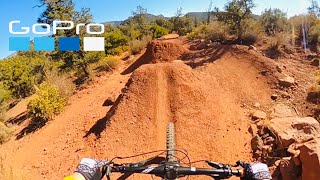
This is a great jump flow trail, with some good size gaps. Many of the jumps require good speed and several are in succession. Best to take a look at the jumps first. Everything is rollable or has a bypass. So you can easily check everything out before. Then pedal hard into the start and let her fly.

You need good speed and you need to hit each jump to make the next one. To make all the biggest gaps, takes expert level jumping skill

Local Trail Association
More Stats for Vortex Flow mountain bike trail trail
  • Altitude change
    -59 ft
  • Altitude min
    4,474 ft
  • Altitude max
    4,536 ft
  • Altitude start
    4,536 ft
  • Altitude end
    4,477 ft
  • Grade
    -5.536%
  • Grade max
    -16.239%
  • Grade min
    4.13%
  • Distance climb
    171 ft
  • Distance down
    875 ft
  • Distance flat
    15 ft
  • Avg time
    00:02:04
  • Avg reverse time
    00:08:22
  • view trail stats
Status:
on Mar 10, 2025
Avg: 4.53 (9 votes)
Your vote: 0

view (4,451)
close
3D
Trail Conditions
  • Unknown
  • Snow Groomed
  • Snow Packed
  • Snow Covered
  • Snow Cover Partial
  • Freeze/thaw Cycle
  • Icy
  • Prevalent Mud
  • Wet
  • Variable
  • Ideal
  • Dry
  • Very Dry
Trail Flow (Ridden Direction)
Trailforks scans users ridelogs to determine the most popular direction each trail is ridden. A good flowing trail network will have most trails flowing in a single direction according to their intension.
The colour categories are based on what percentage of riders are riding a trail in its intended direction.
  • > 96%
  • > 90%
  • > 80%
  • > 70%
  • > 50%
  • < 50%
  • bi-directional trail
  • no data
Trail Last Ridden
Trailforks scans ridelogs to determine the last time a trail was ridden.
  • < 2 days
  • < 1 week
  • < 2 weeks
  • < 1 month
  • < 6 months
  • > 6 months
Trail Ridden Direction
The intended direction a trail should be ridden.
  • Downhill Only
  • Downhill Primary
  • Both Directions
  • Uphill Primary
  • Uphill Only
  • One Direction
Contribute Details
Colors indicate trail is missing specified detail.
  • Description
  • Photos
  • Description & Photos
  • Videos
Trail Popularity ?
Trailforks scans ridelogs to determine which trails are ridden the most in the last 9 months. Trails are compared with nearby trails in the same city region with a possible 25 colour shades. Think of this as a heatmap, more rides = more kinetic energy = warmer colors.
  • most popular
  • popular
  • less popular
  • not popular
ATV/ORV/OHV Filter
Max Vehicle Width
inches
US Cell Coverage
Legend
cell carrier legend

Radar Time
x Activity Recordings
Trailforks users anonymized public ridelogs from the past 6 months.
  • mountain biking recent
  • mountain biking (>6 month)
  • hiking (1 year)
  • moto (1 year)
Activity Recordings
Trailforks users anonymized public skilogs from the past 12 months.
  • Downhill Ski
  • Backcountry Ski
  • Nordic Ski
  • Snowmobile
Winter Trails
Warning A routing network for winter maps does not exist. Selecting trails using the winter trails layer has been disabled.
x Missing Trails
Most Popular
Least Popular
Trails are colored based on popularity. The more popular a trail is, the more red. Less popular trails trend towards green.
Jump Magnitude Heatmap
Heatmap of where riders jump on trails. Zoom in to see individual jumps, click circles to view jump details.
Trails Deemphasized
Trails are shown in grey.
disable
Only show trails with NO bikes.
enable

Save the current map location and zoom level as your default home location whenever this page is loaded.

Save
      Directions to vortex-flow trailhead (34.870490, -111.784920)

      Recent Ridelog Activity on Trail

      Past Week
      • 0 rides
      •  
      6 Months
      • 38 rides
      • 10 miles avg distance
      All
      • 275 rides
      • Last: Mar 25, 2025

      Photos

      more »
      205 |
      Mar 2, 2020 @ 12:27pm
      Mar 2, 2020
      376 |
      Mar 2, 2020 @ 12:26pm
      Mar 2, 2020

      Trail Lists

      1 Review & Comments


      We hope you've been enjoying Trailforks!

      Create a FREE account to view trail comments and much more.

      Videos

      more »
      Sedona's Sick Bike Park! - Guided Tour - Dust...
      9:32 | 70 | Dec 19, 2023 , Sedona
      Getting Pumped!! || Sedona Bike Skills Park...
      14:37 | 272 | Jan 5, 2022 , Sedona
      Awesome bike park in Sedona❗️(GoPro Max)
      4:16 | 417 | Feb 16, 2021 , Sedona
      • By toddTF Pro Trailforks & contributors
      • #165418 - 2,992 views

      You must enter a description before submitting.