Wētā Details
-
Activities
- Mountain Bike
- E-Bike
- Hike
- Trail Running
-
Riding AreaBelmont Regional Park
Lower Hutt -
AKABig Wētā
-
Difficulty Rating
-
Voted DifficultyBlue (2 votes)
-
Trail TypeSingletrack
-
Bike TypeDH, AM, XC, Fat
-
DirectionDownhill OnlyPopular direction shown
-
Trail VisibilityAlways easy to follow
-
Dogs AllowedYes
-
eBike AllowedYes up to Class 1
-
TTFs on TrailBridge, Jump
-
Global Ranking
-
Local Popularity90 in Mountain Biking [+]
- 90 in E-Biking
- 70 in Trail Running
- 5 in Hiking
-
Land Owner
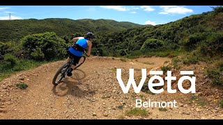
Runs from a skid site half way up Danzig 4x4 slogger road and follows on nicely from Electric Avenue. A bit harder than Electric Avenue. Can also be reached by climbing 4 Degrees and Connect Four. A bit easier than Borderline but still has a couple of sustained steep sections. You could also reach it by coming down the logging track from the Old Coach Road, but you lose a lot of height and the logging track has lots of unpleasant loose shingle and is not not recommended. Lower part can connect with the jumps alternative to the bottom of Borderline.
Weta replaces the destroyed Big weta that existed before the logging.
Local Trail Association
-
Please consider joining or donating to the local trail association to supportdonate to earn trail karma!
trail development & maintenance.
Traditionally Indigenous Territory
More Stats for Wētā mountain bike trail trail
-
Altitude change-271 ft
-
Altitude min572 ft
-
Altitude max843 ft
-
Altitude start843 ft
-
Altitude end571 ft
-
Grade-12.7%
-
Grade max-39.7%
-
Grade min4.4%
-
Distance climb89 ft
-
Distance down1,919 ft
-
Distance flat121 ft
-
Avg time00:02:13
-
Avg reverse time00:01:53
- view trail stats
- Unknown
- Snow Groomed
- Snow Packed
- Snow Covered
- Snow Cover Inadequate
- Freeze/thaw Cycle
- Icy
- Prevalent Mud
- Wet
- Variable
- Ideal
- Dry
- Very Dry
The colour categories are based on what percentage of riders are riding a trail in its intended direction.
- > 96%
- > 90%
- > 80%
- > 70%
- > 50%
- < 50%
- bi-directional trail
- no data
- < 2 days
- < 1 week
- < 2 weeks
- < 1 month
- < 6 months
- > 6 months
- Downhill Only
- Downhill Primary
- Both Directions
- Uphill Primary
- Uphill Only
- One Direction
- Description
- Photos
- Description & Photos
- Videos
- most popular
- popular
- less popular
- not popular
- mountain biking recent
- mountain biking (>6 month)
- hiking (1 year)
- moto (1 year)
- Downhill Ski
- Backcountry Ski
- Nordic Ski
- Snowmobile
Save the current map location and zoom level as your default home location whenever this page is loaded.
SaveWētā Trail Reports
Recent Ridelog Activity on Trail
Past Week
- 11 rides
- 10 miles avg distance
6 Months
- 316 rides
- 9 miles avg distance
All
- 2,904 rides
- Last: Mar 25, 2023
Routes with this trail
3 Reviews & Comments
-
- 1


Videos
Nearby Trails
- Off Camber Daze 1,047 ft
- Connect Four 1,598 ft
- Connector 1,772 ft
- Electric Avenue 2,011 ft
- Connector 2,090 ft
Belmont Regional Park
- embed Wētā trail on your website
- By angusnz
BAMBA & contributors
- #31455 - 6,505 views
- subscribe
- login to download gpx or kml files.