more stats
3,123 ft
Distance
58 ft
Climb
-438 ft
Descent
00:15:45
Avg time
-380 ft
Altitude change
2,835 ft
Altitude min
3,214 ft
Altitude max
3,214 ft
Altitude start
2,835 ft
Altitude end
-12.2%
Grade
-52.6%
Grade max
28.2%
Grade min
466 ft
Distance climb
2,306 ft
Distance down
351 ft
Distance flat
00:15:45
Avg time

Working Class Details

  • Activities
    • Mountain Bike
    • E-Bike
  • Riding Area
    Westside - Sproatt
    Whistler, British Columbia
  • Difficulty Rating
  • Voted Difficulty
    Black Diamond (3 votes)
  • Local Popularity
    70 in Mountain Biking [+]
    • 65 in E-Biking
  • Global Ranking
    #42671 in Mountain Biking [+]
    • #55707 in E-Biking
  • Trail Type
    Singletrack
  • Bike Type
    AM
  • Direction
    Downhill Only
    Popular Direction Shown
  • Climb Difficulty
    Black Diamond
  • Physical Rating
    Hard
  • Trail Visibility
    Always easy to follow
  • Dogs Allowed
    Yes
  • eBike Allowed
    Yes up to Class 1
  • TTFs on Trail
    Drop, Rock Face
  • Year Opened
    2016

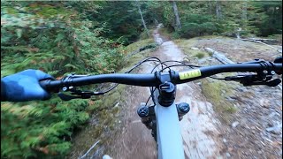
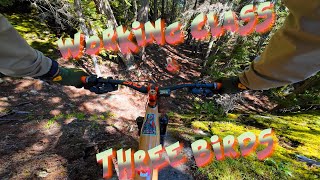
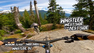
Working Class can be described as a mixture of High Society and Pura Vida, and it has some interesting rock lines along with several chutes. It can be considered and "easy" double-black (in comparison to other double blacks). If you are looking for a trail to challenge the advanced rider, this could be for you.

Access Info

A little ways past High Society on the Flank Trail.

Local Trail Association

Recent Activity on Trail

Past Week
  • 3 rides
  • 12 miles average
6 Months
  • 20 rides
  • 10 miles avg distance
All
  • 542 rides
  • Last: Jun 2, 2026
c1c2c3c4
January
February
March
April
May
June
July
August
September
October
November
December
Status:
on May 30, 2026
Ideal
Avg: 4.19 (25 votes)
Your vote: 0

view (3,141)
close
3D
Trail Conditions
  • Unknown
  • Snow Groomed
  • Snow Packed
  • Snow Covered
  • Snow Cover Partial
  • Freeze/thaw Cycle
  • Icy
  • Prevalent Mud
  • Wet
  • Variable
  • Ideal
  • Dry
  • Very Dry
Trail Flow (Ridden Direction)
Trailforks scans users ridelogs to determine the most popular direction each trail is ridden. A good flowing trail network will have most trails flowing in a single direction according to their intension.
The colour categories are based on what percentage of riders are riding a trail in its intended direction.
  • > 96%
  • > 90%
  • > 80%
  • > 70%
  • > 50%
  • < 50%
  • bi-directional trail
  • no data
Trail Last Ridden
Trailforks scans ridelogs to determine the last time a trail was ridden.
  • < 2 days
  • < 1 week
  • < 2 weeks
  • < 1 month
  • < 6 months
  • > 6 months
Trail Ridden Direction
The intended direction a trail should be ridden.
  • Downhill Only
  • Downhill Primary
  • Both Directions
  • Uphill Primary
  • Uphill Only
  • One Direction
Contribute Details
Colors indicate trail is missing specified detail.
  • Description
  • Photos
  • Description & Photos
  • Videos
Trail Popularity ?
Trailforks scans ridelogs to determine which trails are ridden the most in the last 9 months. Trails are compared with nearby trails in the same city region with a possible 25 colour shades. Think of this as a heatmap, more rides = more kinetic energy = warmer colors.
  • most popular
  • popular
  • less popular
  • not popular
ATV/ORV/OHV Filter
Max Vehicle Width
inches
US Cell Coverage
Legend
cell carrier legend

Radar Time
Activity Recordings
Trailforks uses anonymized public activity data. ?
Activity Recordings
Trailforks uses anonymized public activity data. ?
Personal Heatmap
Activity Types
all / none
Options
2
Date range month
Winter Trails
Warning A routing network for winter maps does not exist. Selecting trails using the winter trails layer has been disabled.
Missing Trails
Most Popular
Least Popular
Trails are colored based on popularity. The more popular a trail is, the more red. Less popular trails trend towards green.
Jump Magnitude Heatmap
Heatmap of where riders jump on trails. Zoom in to see individual jumps, click circles to view jump details.
BC Backroad Status

Service Road Atlas is a free to use, community-driven service for viewing and creating reports on the numerous back-country service roads around B.C. and Alberta.

map legend
Slope Aspect
Direction the slope faces
Flat N NE E SE S SW W NW
Trails Deemphasized
Trails are shown in grey.
disable
Only show trails with no bike usage.
Enable
Suggested Layers
Based on selected activity type

    Save the current map location and zoom level as your default home location whenever this page is loaded.

    Save
        Directions to working-class trailhead (50.105580, -123.014960)

        Photos

        24 more »
        460 |
        Aug 14, 2020 @ 8:25pm
        Aug 14, 2020
        100 |
        Aug 20, 2023 @ 9:24pm
        Aug 20, 2023
        180 |
        Sep 12, 2021 @ 5:56pm
        Sep 12, 2021
        767 |
        Oct 22, 2020 @ 8:00am
        Oct 22, 2020

        Videos

        8 more »
        youtuber WORKING CLASS | Black trail | Whistler
        5:10 | 322 | Nov 27, 2023 , Whistler
        A Swiss biker in BC EP 30 II Working Class |...
        5:44 | 51 | Sep 14, 2025 , Whistler
        Lord Of The Squirrels - Sept 29th
        1:15:23 | 114 | Oct 8, 2024 , Whistler
        Whistler West Side is the Best Side | Working...
        8:49 | 205 | Oct 23, 2023 , Whistler

        Trail Lists

        Routes with this trail

        4.2 13 miles 1,896 ft 41 Loop
        A Sample of Whistler's Westside is an advanced technical trail featuring several rockfaces, difficult...
        2.0 6 miles 2,089 ft 6
        Stage 1: "Hardly Working" This is the most XC feeling stage of the race and a nice way to start the day!...
        4 miles 1,446 ft 3
        Prizing: WORCA prize packs Each pack consists of a t-shirt and water bottle. Get out for a virtual ride...

        Trail Products

        6 Reviews & Comments


        We hope you've been enjoying Trailforks!

        Create a FREE account to view trail comments and much more.

        • By canadakaTF Pro Trailforks & contributors
        • #61851 - 11,919 views

        Frequently Asked Questions About Working Class

        Where is Working Class located?
        Working Class is located in Westside - Sproatt, Whistler, British Columbia, Canada. It is part of the Westside - Sproatt trail network. The trailhead is located at coordinates 50.10558, -123.01496.
        How hard is Working Class?
        Working Class is rated as Black Diamond difficulty. The physical rating is Hard. The average grade is 12.2%. The climb difficulty is rated Black Diamond.
        What is the elevation gain for Working Class?
        Working Class has 58 ft of elevation gain. The trail has 438 ft of elevation descent. The elevation ranges from 2,835 ft to 3,214 ft.
        Is Working Class a point to point trail?
        Yes, Working Class is a point to point trail. The direction is Downhill Only. The trail type is singletrack.

        Hit the Trail

        Open in App

        Get this trail on your phone instantly.
        open trail in app

        Download Trail

        Save to wishlist, Garmin & download.
        save the trail

        Find Related Routes

        Find routes and users activities that include this trail.
        find routes for this trail

        You must enter a description before submitting.