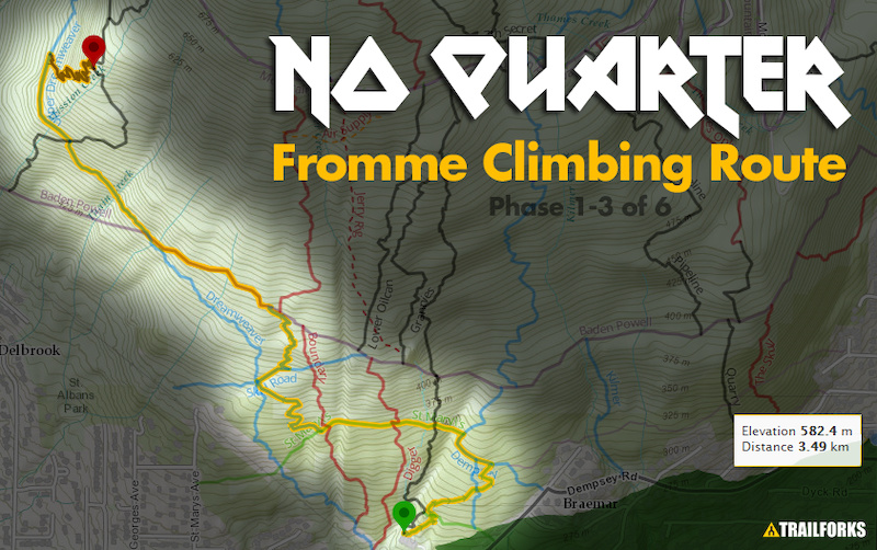
Collection of new climbing connectors and some old trail creating a Fromme west side access climbing route. Don't let the green & blue difficulty ratings of a lot of the trail sections fool you, this is a tough climb. The trail ratings are mostly their downhill rating. This is a physically demanding climb that gets more challenging the further you go.
The NSMBA heartily thanks all of the volunteers, lead builders and groups who provided support to get the route opened to this point including: Arc'teryx, MEC, Rocky Mountain Bicycles, BC Bike Race
Lead Builders: Irish Pete, Pat Podolski, Digger, Brent Hillier, Owen Thomas, Chris Barker, Tom Hudson, Randy Konrad
Route Supporters

Giant Canada- Peter MorinBuilder
- Joe WoywitkaBuilder
Local Trail Association
Trail Products
69 Reviews & Comments
We hope you've been enjoying Trailforks!
Create a FREE account to view route comments and much more.
Trails in Route
| 236 ft | |||||
| 1,581 ft | |||||
| 499 ft | |||||
| 1,306 ft | |||||
| 1,286 ft | |||||
| 344 ft | |||||
| 1,007 ft | |||||
| 1,814 ft | |||||
| 1,299 ft | |||||
| 991 ft | |||||
| 1,499 ft | |||||
| 545 ft | |||||
| 1,621 ft | |||||
| 2,585 ft |
Details
-
Riding area
-
Primary ActivityMountain Bike
-
AKAfromme grinder, Fromme Ascent
-
Difficulty ratingBlack Diamond
-
Route TypePoint to Point
-
Bike typeAM
-
DirectionBoth Directions
-
Physical ratingHard
-
Ridelogs
More Stats for No Quarter (Fromme Climbing Route) mountain bike route
-
Avg time57 min 36 sec
-
Altitude change1,314 ft
-
Altitude min936 ft
-
Altitude start936 ft
-
Altitude end2,251 ft
-
Grade8.1%
-
Grade max-25.9%
-
Grade min39.3%
-
Distance climb2 miles
-
Distance down2,411 ft
-
Distance flat741 ft
Directions
- Walk northwest on Mountain Highway.
- Continue for 700 meters.
- Turn right onto Pile of Rocks.
- Continue for 30 meters.
- Walk northwest on Mountain Highway.
- Continue for 700 meters.
- Walk northeast on Mountain Highway.
- Continue for 100 meters.
- Turn right onto Upper Oilcan.
- Continue for 700 meters.
- Turn left onto Mountain Highway.
- Continue for 600 meters.
- Turn right onto Ladies Only.
- Continue for 300 meters.
- Turn left onto Emergency Access.
- Continue for 50 meters.
- Turn right onto Mountain Highway.
- Continue for 1.5 kilometers.
- Turn right onto Decommisioned Trail.
- Continue for 300 meters.
- Turn left onto Mountain Highway.
- Continue for 100 meters.
- Turn right onto Cedar Tree Trail.
- Continue for 400 meters.
- Keep left to take Kirkford.
- Continue for 50 meters.
- Walk northeast on Leppard.
- Continue for 70 meters.
- Keep right to stay on Leppard.
- Continue for 600 meters.
- Walk north on Leppard.
- Continue for 40 meters.
- Turn left onto Crinkum Crankum.
- Continue for 500 meters.
- Make a sharp right onto Crinkum Access.
- Continue for 80 meters.
- Walk northwest on Crinkum Access.
- Continue for 80 meters.
- Make a sharp left onto Crinkum Crankum.
- Continue for 500 meters.
- Turn left onto Access to Crinkum.
- Continue for 100 meters.
- Turn left onto Mountain Highway.
- Continue for 60 meters.
- Turn left onto Warden's Climb.
- Continue for 200 meters.
- Turn left onto Mountain Highway.
- Continue for 500 meters.
- Walk southeast on Crinkum Access.
- Continue for 60 meters.
- Walk north on Kirkford.
- Continue for 500 meters.
- Walk south on Cedar Tree Trail.
- Continue for 300 meters.
- Bear left onto Roadside Attraction.
- Continue for 60 meters.
- Turn left onto Upper Griffen.
- Continue for 400 meters.
- Walk east on Upper Griffen.
- Continue for 30 meters.
- Turn left onto Parking Lot Connector.
- Continue for 10 meters.
- Turn right onto Middle Griffen.
- Continue for 400 meters.
- Walk south on Middle Griffen.
- Continue for 400 meters.
-
Layers w
- Map Content
- More Layers
- Pro
- Pro
- Pro
- Pro
- Pro
- Pro
- Pro
- Pro
-
Upgrade to

- Unknown
- Snow Groomed
- Snow Packed
- Snow Covered
- Snow Cover Partial
- Freeze/thaw Cycle
- Icy
- Prevalent Mud
- Wet
- Variable
- Ideal
- Dry
- Very Dry
The colour categories are based on what percentage of riders are riding a trail in its intended direction.
- > 96%
- > 90%
- > 80%
- > 70%
- > 50%
- < 50%
- bi-directional trail
- no data
- < 2 days
- < 1 week
- < 2 weeks
- < 1 month
- < 6 months
- > 6 months
- Downhill Only
- Downhill Primary
- Both Directions
- Uphill Primary
- Uphill Only
- One Direction
- Description
- Photos
- Description & Photos
- Videos
- most popular
- popular
- less popular
- not popular

- mountain biking recent
- mountain biking (>6 month)
- hiking (1 year)
- moto (1 year)
- Downhill Ski
- Backcountry Ski
- Nordic Ski
- Snowmobile
Save the current map location and zoom level as your default home location whenever this page is loaded.
SavePhotos
Videos


Recent Trail Reports Along Route
| status | trail | date | condition | description |
|---|---|---|---|---|
May 12, 2024 @ 2:06am 2 days | Running well. | |||
May 12, 2024 @ 2:06am 2 days | ||||
May 12, 2024 @ 2:06am 2 days | ||||
May 12, 2024 @ 2:06am 2 days | ||||
May 8, 2024 @ 3:41am May 8, 2024 |
- By canadaka
 Trailforks & contributors
 - #133 - 42,969 views