close
-
Layers w
- Weather Layers
- Pro
- Pro
- Pro
- Pro
- Pro
- Pro
- More Layers
- Pro
- Pro
- Pro
- Pro
-
Upgrade to

3D
Trail Conditions
- Unknown
- Snow Groomed
- Snow Packed
- Snow Covered
- Snow Cover Partial
- Freeze/thaw Cycle
- Icy
- Prevalent Mud
- Wet
- Variable
- Ideal
- Dry
- Very Dry
Trail Flow (Ridden Direction)
Trailforks scans users ridelogs to determine the most popular direction each trail is ridden. A good flowing trail network will have most trails flowing in a single direction according to their intension.
The colour categories are based on what percentage of riders are riding a trail in its intended direction.
The colour categories are based on what percentage of riders are riding a trail in its intended direction.
- > 96%
- > 90%
- > 80%
- > 70%
- > 50%
- < 50%
- bi-directional trail
- no data
Trail Last Ridden
Trailforks scans ridelogs to determine the last time a trail was ridden.
- < 2 days
- < 1 week
- < 2 weeks
- < 1 month
- < 6 months
- > 6 months
Trail Ridden Direction
The intended direction a trail should be ridden.
- Downhill Only
- Downhill Primary
- Both Directions
- Uphill Primary
- Uphill Only
- One Direction
Contribute Details
Colors indicate trail is missing specified detail.
- Description
- Photos
- Description & Photos
- Videos
Trail Popularity ?
Trailforks scans ridelogs to determine which trails are ridden the most in the last 9 months.
Trails are compared with nearby trails in the same city region with a possible 25 colour shades.
Think of this as a heatmap, more rides = more kinetic energy = warmer colors.
- most popular
- popular
- less popular
- not popular
ATV/ORV/OHV Filter
Max Vehicle Width
inches
US Cell Coverage
Legend

Radar Time
Activity Recordings
Trailforks uses anonymized public activity data.
?
Activity Recordings
Trailforks uses anonymized public activity data.
?
Personal Heatmap
▶
Activity Types
all
/
none
▶
Options
2
Date range
month
–
Winter Trails
Warning
A routing network for winter maps does not exist. Selecting trails using the winter trails layer has been disabled.
Missing Trails
Most Popular
Least Popular
Trails are colored based on popularity. The more popular a trail is, the more red. Less popular trails trend towards green.
Jump Magnitude Heatmap
Heatmap of where riders jump on trails. Zoom in to see individual jumps, click circles to view jump details.
BC Backroad Status
![map legend]()
Service Road Atlas is a free to use, community-driven service for viewing and creating reports on the numerous back-country service roads around B.C. and Alberta.

Slope Aspect
Direction the slope faces
Trails Deemphasized
Trails are shown in grey.
Only show trails with no bike usage.
Suggested Layers
Based on selected activity type
Save the current map location and zoom level as your default home location whenever this page is loaded.
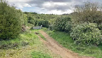
SaveFor competent riders, 2-5 hours, 30km of trails in total.
Over 30km of trail is available for riding at Arapuke. Trails are mainly a mixture of grade 3 and grade 4 trails for intermediate to advanced riders, with a couple of grade 5 trails thrown in. There is plenty of smooth flowing trails to reward the 4km climb up Back Track. to get there or you can take a drive up Scott's Rd to the new car park and enjoy the trails at the top.
You can check the conditions via the webcam near the top of the park, or the weather station.
Primary Trail Type: All-Mountain & Downhill
eBikes Allowed:
Yes
Shuttleable: YES
AKA: Kahuterawa (K-Loop)
Land Status: City Managed
Land Manager: Palmerston North City Council
 google parking directions
 Access Info:
End of Kahuterawa Road, or Scotts Road
Links
Activities Click to view
- Mountain Bike
46 trails
- E-Bike
31 trails
- Gravel Bike
11 trails
- Hike
10 trails
- Trail Running
10 trails
Bike Park Details
- 9
- 4
- 11
- 4
- 7
- 1
Region Status
Open as of Jan 16, 2026- Uplift Type
- Shuttle
Stats
- Avg Trail Rating
- Trails (view details)
- 46
- Trails Mountain Bike
- 46
- Trails E-Bike
- 31
- Trails Gravel Bike
- 11
- Trails Hike
- 10
- Trails Trail Running
- 10
- Total Distance
- 29 miles
- Total Descent
- 9,559 ft
- Total Vertical
- 977 ft
- Highest Trailhead
- 1,457 ft
- Reports
- 389
- Photos
- 118
- Ridden Counter
- 21,523
Popular Arapuke Forest Mountain Biking Trails
• 75 ★ 4.5 • 1 mile • 70 ft • 629 •
Mr. Twister was edited and extended by Empire of Dirt and also Velstand Trails in 2019. It is a wide open Grade 3 flow trail. This trail is an ideal one for progressing on as it is a safe way down the hill and our recommended park EXIT...
• 80 ★ 3.2 • 1,460 ft • 33 ft • 603 •
is a loop, between the top of and the Container Hub. From the Hub you can cross Arapuke Rd to the start of , join the top part of or ride . If you continue down , you end up back where you started, but if you head into this makes a...
• 90 ★ 4.0 • 2,743 ft • 3 ft • 575 •
was designed to give riders an introduction to air time. A couple of rollers beside the road to warm you up lead you into a steepish descending right hand berm, swoop through the next 3 berms and down to the first table top. All of the...
• 70 ★ 3.6 • 1 mile • 65 ft • 569 •
A predominantly downhill flowing trail with lots of berms and a smooth surface that's fun for all the family. Running from the summit of the park this trail has has a few incarnations over the years. The berms and rollers make for great...
• 85 ★ 4.0 • 4,199 ft • 537 ft • 539 •
This trail winds gently through 400 m or so of native bush, crossing several culverts before coming out on to the hillside amongst the new growth forest on the way to the top of its 1.5 km length. Running at an average 4% gradient, this...
• 85 ★ 4.5 • 2,156 ft • 0 ft • 537 •
follows the old downhill trail built in 2013 by some of our young lads who wanted a trail of berms and jumps. Accessed from the start of it sweeps its way down the hill beside with big corners and jumps. All the jumps in the top section...
• 95 ★ 4.7 • 2 miles • 568 ft • 521 •
is a meandering, well-graded uphill trail that offers great views back down Kahuterawa valley. It winds its way via switchbacks and stream crossings till the crossing of . Once across the trail has continues back into new growth forest...
Arapuke Forest Mountain Bike Routes
7 miles • 2,049 ft • 5 • Loop •
This loop follows the 4km (G2) from the bottom of Arapuke Bike park to the upper Scotts Road car park...
12 miles • 2,111 ft • 18 • Loop •
Arapuke Classic 2026 18/36km Course - Icebreaker Icebreaker to 2 2 to Junction in reverse to the Foo...
12 miles • 2,310 ft • 197 • Loop •
All the trails in the park less the grade 5 trails and jump track. From Kahuterawa Rd car park head up the...
2,313 ft • 2 • Point to Point •
This stage starts at the top of the park and is run over (G4) and finishes in the vicinity of the...
1,916 ft • 2 • Point to Point •
This stage starts at the top of the park and is run over (G4) and finishes in the vicinity of the...
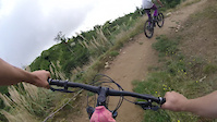
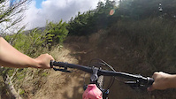
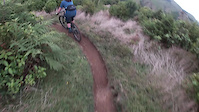
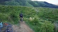
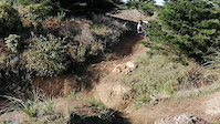
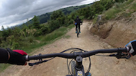
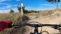
Photos of Arapuke Forest Mountain Bike
Videos of Arapuke Forest Mountain Bike
trail: Mind the Gap
0:12 |
1 |
Mar 19, 2023
trail: Mr Twister
0:09 |
|
Mar 12, 2023
trail: Foo Fighter
0:09 |
|
Mar 12, 2023
trail: Kārearea
0:13 |
202 |
May 15, 2022
trail: Chewbacca
0:04 |
222 |
Oct 2, 2021
trail: Jumping Jack
0:10 |
211 |
Jun 11, 2021
trail: Mr Twister
0:50 |
113 |
Feb 26, 2021
trail: Jumping Jack
2:25 |
80 |
Feb 26, 2021
Recent Trail Reports
| status | trail | date | condition | info | user |
|---|---|---|---|---|---|
| Back Track | Jan 17, 2026 @ 11:40am (Pacific/Auckland) Jan 16, 2026 | Variable | evandnz | ||
| Rhythm and Vines | Jan 17, 2026 @ 11:38am (Pacific/Auckland) Jan 16, 2026 | Wet | evandnz | ||
| Foo Fighter | Jan 14, 2026 @ 8:50pm (Pacific/Auckland) Jan 13, 2026 | Unknown | harrywells | ||
| Humpty Jumpty | Oct 25, 2025 @ 6:03pm (Pacific/Auckland) Oct 24, 2025 | Ideal | MountainbikerDan | ||
| Mr Twister | Oct 25, 2025 @ 5:57pm (Pacific/Auckland) Oct 24, 2025 | Ideal | MountainbikerDan | ||
| About Time | Sep 1, 2024 @ 11:24pm Sep 1, 2024 | Ideal | Outdoor_dude | ||
| Mind the Gap | Mar 31, 2024 @ 3:59pm Mar 31, 2024 | Dry | lachiemartin | ||
| Shuttle Rd | Mar 31, 2024 @ 3:59pm Mar 31, 2024 | Dry | lachiemartin | ||
| Riff Raff | Mar 31, 2024 @ 3:59pm Mar 31, 2024 | Dry | lachiemartin | ||
| Kissing Rock | Feb 13, 2024 @ 5:31pm Feb 13, 2024 | Dry | RobbieSmith-92 |
Activity Feed
| username | action | type | title | date |
|---|---|---|---|---|
| PaulQP8RlG | ridden | trail | activity #97723551 | Jun 24, 2026 @ 2:13pm 2 days |
| xCoster | wishlist | region | activity #95288538 | May 22, 2026 @ 9:07pm May 22, 2026 |
| qiwern | ridden | trail | activity #93425115 and 4 more | Apr 26, 2026 @ 3:40am Apr 26, 2026 |
| yannZ3hA | checkin | trail | activity #91564918 | Mar 29, 2026 @ 5:48pm Mar 29, 2026 |
| yannZ3hA | ridden | trail | activity #91564917 | Mar 29, 2026 @ 5:48pm Mar 29, 2026 |
Recent Comments
| username | type | title | comment | date |
|---|---|---|---|---|
| trail | Absolutely fantastic family friendly trail... | Oct 25, 2024 @ 3:23am Oct 25, 2024 | ||
| trail | Didn’t find anything challenging enough with... | Jan 7, 2024 @ 12:36am Jan 7, 2024 | ||
| trail | Top section is fun and flowey and a solid 3 -... | Jan 7, 2024 @ 12:32am Jan 7, 2024 | ||
| trail | Excellent uphill track. A few challenging... | Jan 7, 2024 @ 12:29am Jan 7, 2024 | ||
| trail | Fun! Great track. I’m not a big jumper but... | Jan 7, 2024 @ 12:27am Jan 7, 2024 |
Nearby Areas
| name | distance | ||||
|---|---|---|---|---|---|
| Paneiri Park | 4 | 3 | 6.1 km | ||
| Linklater Reserve | 1 | 10.2 km | |||
| Te Apiti | 3 | 1 | 14 km | ||
| Manawatu Gorge Scenic Reserve | 1 | 14.1 km | |||
| Aorangi Trails, Feilding | 16.1 km |
Local Badges
-

Completionist3 awarded
Activity Type Stats
| activitytype | trails | distance | descent | descent distance | total vertical | rating | global rank | state rank | photos | reports | routes | ridelogs |
|---|---|---|---|---|---|---|---|---|---|---|---|---|
| Mountain Bike | 46 | 29 miles | 9,560 ft | 14 miles | 978 ft | #452 | #18 | 118 | 389 | 37 | 5,785 | |
| E-Bike | 31 | 22 miles | 7,956 ft | 11 miles | 978 ft | #1,213 | #42 | 361 | 3 | 945 | ||
| Gravel Bike | 11 | 6 miles | 991 ft | 2 miles | 935 ft | #35 | #2 | 72 | 1 | 2 | ||
| Hike | 10 | 6 miles | 1,247 ft | 2 miles | 935 ft | #4,102 | #73 | 323 | 1 | 75 | ||
| Trail Running | 10 | 6 miles | 1,247 ft | 2 miles | 935 ft | #3,243 | #58 | 323 | 100 |
Frequently Asked Questions About Arapuke Forest
▼
What are the highest rated mountain biking trails in Arapuke Forest?
The highest rated mountain biking trails in Arapuke Forest are:
- Chewbacca (4.5/5)
- Kissing Rock (4.4/5)
- Foo Fighter (4.4/5)
- Rambo (4.4/5)
- Mr Twister (4.3/5)
▼
What is the best time of the year to ride in Arapuke Forest?
Based on ride log data, the most popular months to ride in Arapuke Forest are:
- February (50 activities)
- March (31 activities)
- December (29 activities)
▼
Where can I park to ride in Arapuke Forest?
There are 3 parking locations listed in Arapuke Forest. The most popular parking spots are: View all parking and trailhead locations on the map to plan your visit.
▼
What is the longest trail in Arapuke Forest?
The longest trail in Arapuke Forest is Te Ara Kaikohi at 3.0 miles. View all trails sorted by distance.
Activities
Trails
Points of Interest
- By RoccoNZ & contributors
- Admins: MMBC, russell-brebner, harrywells
- #7174 - 35,577 views
- arapuke forest activity log | embed map of Arapuke Forest mountain bike trails | arapuke forest mountain biking points of interest
Downloading of trail gps tracks in kml & gpx formats is enabled for Arapuke Forest.
You must login to download files.