close
-
Layers w
- Weather Layers
- Pro
- Pro
- Pro
- Pro
- Pro
- Pro
- More Layers
- Pro
- Pro
- Pro
- Pro
-
Upgrade to

3D
Trail Conditions
- Unknown
- Snow Groomed
- Snow Packed
- Snow Covered
- Snow Cover Partial
- Freeze/thaw Cycle
- Icy
- Prevalent Mud
- Wet
- Variable
- Ideal
- Dry
- Very Dry
Trail Flow (Ridden Direction)
Trailforks scans users activity logs to determine the most popular direction each trail is ridden. A good flowing trail network will have most trails flowing in a single direction according to their intension.
The colour categories are based on what percentage of users are riding a trail in its intended direction.
The colour categories are based on what percentage of users are riding a trail in its intended direction.
- > 96%
- > 90%
- > 80%
- > 70%
- > 50%
- < 50%
- bi-directional trail
- no data
Trail Last Ridden
Trailforks scans activity logs to determine the last time a trail was ridden.
- < 2 days
- < 1 week
- < 2 weeks
- < 1 month
- < 6 months
- > 6 months
Trail Ridden Direction
The intended direction a trail should be ridden.
- Downhill Only
- Downhill Primary
- Both Directions
- Uphill Primary
- Uphill Only
- One Direction
Contribute Details
Colors indicate trail is missing specified detail.
- Description
- Photos
- Description & Photos
- Videos
Trail Popularity ?
Trailforks scans activity logs to determine which trails are ridden the most in the last 9 months.
Trails are compared with nearby trails in the same city region with a possible 25 colour shades.
Think of this as a heatmap, more activities = more kinetic energy = warmer colors.
- most popular
- popular
- less popular
- not popular
ATV/ORV/OHV Filter
Max Vehicle Width
inches
US Cell Coverage
Legend

Radar Time
Activity Recordings
Trailforks uses anonymized public activity data.
?
Activity Recordings
Trailforks uses anonymized public activity data.
?
Personal Heatmap
▶
Activity Types
all
/
none
▶
Options
2
Date range
month
–
Winter Trails
Warning
A routing network for winter maps does not exist. Selecting trails using the winter trails layer has been disabled.
Missing Trails
Most Popular
Least Popular
Trails are colored based on popularity. The more popular a trail is, the more red. Less popular trails trend towards green.
Jump Magnitude Heatmap
Heatmap of where users jump on trails. Zoom in to see individual jumps, click circles to view jump details.
BC Backroad Status
![map legend]()
Service Road Atlas is a free to use, community-driven service for viewing and creating reports on the numerous back-country service roads around B.C. and Alberta.

Slope Aspect
Direction the slope faces
Trails Deemphasized
Trails are shown in grey.
Only show trails with no bike usage.
Suggested Layers
Based on selected activity type
Save the current map location and zoom level as your default home location whenever this page is loaded.
Save
No description for Salida has been added yet!
Login or register to submit one.
Links
Activities Click to view
- Mountain Bike
216 trails
- E-Bike
69 trails
- Gravel Bike
24 trails
- Adaptive Bike
0 trails
- Winter Fat Bike
0 trails
- Horse
48 trails
- Hike
231 trails
- Trail Running
231 trails
- Dirtbike/Moto
45 trails
- ATV/ORV/OHV
18 trails
- Downhill Ski
67 trails
Region Details
- 84
- 16
- 21
- 44
- 45
- 4
Region Status
Open as of Jul 19, 2026Stats
- Avg Trail Rating
- Trails (view details)
- 296
- Trails Mountain Bike
- 216
- Trails E-Bike
- 69
- Trails Gravel Bike
- 24
- Trails Horse
- 48
- Trails Hike
- 231
- Trails Trail Running
- 231
- Trails Dirtbike/Moto
- 45
- Trails ATV/ORV/OHV
- 18
- Trails Snowmobile
- 4
- Trails Snowshoe
- 4
- Trails Downhill Ski
- 67
- Trails Backcountry Ski
- 1
- Trails Nordic Ski
- 3
- Total Distance
- 612 miles
- Total Descent
- 106,037 ft
- Total Vertical
- 7,690 ft
- Highest Trailhead
- 14,214 ft
- Reports
- 1,724
- Photos
- 446
- Completed Counter
- 77,165
Sub Regions
-
Arkansas Hills Trails
- 5
- 9
- 12
- 2
-
Methodist Mountain Trail System
- 5
- 6
- 14
- 5
-
Monarch Pass
-
Sangre de Cristo Wilderness
Popular Salida Mountain Biking Trails
• 90 ★ 4.7 • 10 miles • 1,005 ft • 2,044 •
is an epic High Country ride! Super popular and for good reason. After you climb the dirt road and do a short climb, the views are amazing, and then more amazing as you navigate between small peaks. The views are 360 and you can see...
• 100 ★ 4.2 • 4,751 ft • 200 ft • 1,962 •
Many of the rides on the Arkansas Hills system will start out with a climb that includes . It is an easy/intermediate trail that climbs out of the S-Mountain parking lot. It meanders up and around a few hills and then meets the spiral...
• 90 ★ 3.8 • 3 miles • 615 ft • 1,946 •
Popular blue difficulty singletrack. This mountain bike primary trail can be used downhill primary. On average it takes 46 minutes to complete this trail.
• 90 ★ 4.3 • 4 miles • 96 ft • 1,893 •
A challenging and lengthy trail that runs from near the top of windy peak down to the start of Rainbow. It's an 1800+ foot drop that crosses almost every kind of trail you can imagine. From loamy flow to hard scrabble to baby head rocks...
• 85 ★ 3.6 • 2 miles • 243 ft • 1,728 •
You've made your way past the slower traffic on and . Your legs are still feeling pretty good and you want more miles before heading back to town. Enter . Expect small rocks, big rocks, rocks you may want to pick your bike up and over....
• 95 ★ 3.7 • 2 miles • 385 ft • 1,649 •
The newest additions to the Arkansas Hills Trail System! was completed in December of 2016. Spicy XC trail, fun on the way down (mostly down, has some pedally bits), pretty easy on the way up.
• 100 ★ 4.3 • 2 miles • 160 ft • 1,616 •
is the heart of the Salida Mountain Trails system. With it, you can really create a lot of different loops to explore the trail system. starts at the end of - very convenient. is a fun, swoopy trail. It's got some rocks, but is not...
• 95 ★ 4.5 • 3 miles • 13 ft • 1,561 •
is a classic Salida trail that dates back to some of the pioneers of mountain biking. It has to be one of the better technical downhills in the area. It has recently had the upper portion rerouted to avoid areas that the Forrest Service...
Salida Mountain Bike Routes
Cottonwood Tour Featured
★ 3.7 • 22 miles • 2,663 ft • 14 • Loop •
This route connects some of the best trails around Salida in the S mountain area. Some connectors are not...
Canyon Creek - Sawatch Featured
★ 5.0 • 19 miles • 3,671 ft • 5 • Loop •
The Monarch Crest receives all the attention, however its the lesser known that deserves more of that...
★ 4.2 • 35 miles • 2,660 ft • 5 • Point to Point •
The typical Monarch Crest route, starting from the ski area, traversing to Marshall Pass.
★ 2.7 • 27 miles • 1,821 ft • 3 • Shuttled •
Popular modified version of the traditional Monarch Crest IMBA classic MTB shuttle route, which skips the...
★ 5.0 • 80 miles • 10,598 ft • 10 • Point to Point •
Put on your big kid pants, grab plenty of snacks, and earn your turns on five (more if you count parts of...
★ 5.0 • 22 miles • 2,943 ft • 13 • Loop •
The Cottonwood Tour but with The Dude Abides detour joining up to North Backbone instead of the full North...
Photos of Salida Mountain Bike
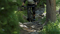
Videos of Salida Mountain Bike
trail: Solstice
0:08 |
53 |
Mar 4, 2025
trail: Starvation Creek
2:55 |
70 |
Nov 4, 2022

trail: Tenderfoot Trail
11:59 |
75 |
Nov 9, 2021

trail: Solstice
4:23 |
343 |
Nov 11, 2020
trail: CDT CT - Monarch Crest Trail
0:54 |
5729 |
Aug 25, 2020
trail: CDT CT - Monarch Crest Trail
0:27 |
47 |
Aug 5, 2020
trail: CDT CT - Monarch Crest Trail
18:57 |
30 |
Dec 10, 2019
trail: Cottonwood
0:18 |
319 |
Jul 29, 2016
Recent Trail Reports
| status | trail | date | condition | info | user |
|---|---|---|---|---|---|
| Monarch Spur Connector | Jul 19, 2026 @ 4:46pm (America/Denver) Jul 19, 2026 | Dry | IndianaGirl O'Bannon | ||
| CDT - Basin View | Jul 19, 2026 @ 7:14pm (America/Denver) Jul 19, 2026 | Unknown | IndianaGirl O'Bannon | ||
| Monarch Ridge | Jul 19, 2026 @ 7:14pm (America/Denver) Jul 19, 2026 | Unknown | IndianaGirl O'Bannon | ||
| Tram Access | Jul 19, 2026 @ 10:36am (America/Denver) Jul 19, 2026 | Unknown | IndianaGirl O'Bannon | ||
| Rainbow | Jul 19, 2026 @ 10:36am (America/Denver) Jul 19, 2026 | Ideal | IndianaGirl O'Bannon | ||
| Silver Creek | Jul 19, 2026 @ 10:36am (America/Denver) Jul 19, 2026 | Ideal | IndianaGirl O'Bannon | ||
| CT - Marshall Pass | Jul 19, 2026 @ 10:36am (America/Denver) Jul 19, 2026 | Ideal | IndianaGirl O'Bannon | ||
| Marshall Rd Connector | Jul 19, 2026 @ 10:36am (America/Denver) Jul 19, 2026 | Dry | IndianaGirl O'Bannon | ||
| CDT CT - Monarch Crest Trail | Jul 19, 2026 @ 10:36am (America/Denver) Jul 19, 2026 | Variable | IndianaGirl O'Bannon | ||
| Dirt Road | Jul 18, 2026 @ 10:21am (America/Denver) Jul 18, 2026 | Ideal | DekeMTB |
National Scenic Trails & Official Routes
-
Colorado Trail (Bike)
- Mountain Bike
-
Continental Divide Trail
- Mountain Bike
- Hike
- Trail Running

Activity Feed
| username | action | type | title | date |
|---|---|---|---|---|
| seantrails | wishlist | route | activity #99876500 | Jul 24, 2026 @ 3:07am 4 hours |
| jmg007007 | wishlist | route | activity #99855202 | Jul 23, 2026 @ 5:00pm 14 hours |
| Randski | wishlist | route | activity #99854501 | Jul 23, 2026 @ 4:50pm 15 hours |
| machoprincess | comment | trail | activity #99825397 | Jul 23, 2026 @ 9:20am 22 hours |
| andylegrunge | difficultyvote | trail | activity #99781390 | Jul 22, 2026 @ 4:13pm 2 days |
Recent Comments
| username | type | title | comment | date |
|---|---|---|---|---|
| trail | Super fun and pretty but I guess it's hard if... | Jul 23, 2026 @ 9:20am 22 hours | ||
| trail | No two ways to put it. This is a big climb but... | Jul 20, 2026 @ 8:15pm Jul 20, 2026 | ||
| trail | Greens creek is running perfect right now. I... | Jul 20, 2026 @ 8:10pm Jul 20, 2026 | ||
| trail | fun section. definitely not black, mostly... | Jul 16, 2026 @ 9:21am Jul 16, 2026 | ||
| trail | Some really interesting and challenging tech,... | Jun 25, 2026 @ 11:07am Jun 25, 2026 |
Local Badges
-

Top 10 Trails26 awarded -

Descent 100k Badge17 awarded -

Big Ride 30k5,995 awarded -

Epic Ride 50k2,497 awarded -

Descent 10k Badge251 awarded -

Completionist3 awarded
Bike & Skill Parks
| name | type | city | rating |
|---|---|---|---|
| Monarch Mountain | bike park | Salida |
Activity Type Stats
| activitytype | trails | distance | descent | descent distance | total vertical | rating | global rank | state rank | photos | reports | routes | activity logs |
|---|---|---|---|---|---|---|---|---|---|---|---|---|
| Mountain Bike | 216 | 572 miles | 93,028 ft | 254 miles | 7,690 ft | #161 | #61 | 413 | 1,723 | 37 | 40,232 | |
| E-Bike | 69 | 275 miles | 46,076 ft | 120 miles | 7,251 ft | #402 | #705 | 1,469 | 2 | 1,279 | ||
| Gravel Bike | 24 | 82 miles | 9,081 ft | 34 miles | 4,934 ft | #155 | #799 | 126 | 1 | 390 | ||
| Horse | 48 | 241 miles | 39,144 ft | 102 miles | 5,869 ft | #95 | #365 | 454 | 2 | |||
| Hike | 231 | 592 miles | 93,934 ft | 257 miles | 7,690 ft | #131 | #77 | 34 | 1,712 | 31 | 4,321 | |
| Trail Running | 231 | 592 miles | 93,934 ft | 257 miles | 7,690 ft | #122 | #59 | 1,712 | 32 | 2,011 | ||
| Dirtbike/Moto | 45 | 233 miles | 37,556 ft | 106 miles | 7,244 ft | #89 | #55 | 437 | 2 | 71 | ||
| ATV/ORV/OHV | 18 | 78 miles | 5,968 ft | 26 miles | 4,393 ft | #210 | #81 | 3 | 415 | 1 | 6 | |
| Snowmobile | 4 | 8 miles | 62 ft | 1,877 ft | 2,897 ft | 1 | 3 | |||||
| Snowshoe | 4 | 8 miles | 62 ft | 1,877 ft | 2,897 ft | 1 | 2 | 21 | ||||
| Downhill Ski | 67 | 21 miles | 12,106 ft | 15 miles | 1,053 ft | #223 | #89 | 2,301 | ||||
| Backcountry Ski | 1 | 4 miles | 190 ft | 2,897 ft | 301 | |||||||
| Nordic Ski | 3 | 4 miles | 62 ft | 1,686 ft | 1,030 ft | 107 |
Frequently Asked Questions About Salida
▼
What are the best places to ride in Salida?
Salida has 5 areas to explore for mountain biking. The top rated areas are:
▼
What are the highest rated mountain biking trails in Salida?
The highest rated mountain biking trails in Salida are:
- South Fooses Creek (4.5/5)
- CDT CT - Monarch Crest Trail (4.5/5)
- Hooligan (4.5/5)
- Rusty Lung (4.4/5)
- Cottonwood (4.4/5)
▼
What is the best time of the year to ride in Salida?
Based on activity log data, the most popular months to ride in Salida are:
- July (531 activities)
- August (393 activities)
- September (376 activities)
▼
Where can I park to ride in Salida?
There are 33 parking locations listed in Salida. The most popular parking spots are: View all parking and trailhead locations on the map to plan your visit.
Activities
Trails
- By canadaka
 Trailforks & contributors
 - Admins: SMT
- #4950 - 41,450 views
- salida activity log | embed map of Salida mountain bike trails | salida mountain biking points of interest
Downloading of trail gps tracks in kml & gpx formats is enabled for Salida.
You must login to download files.