close
-
Layers w
- Weather Layers
- Pro
- Pro
- Pro
- Pro
- Pro
- Pro
- More Layers
- Pro
- Pro
- Pro
- Pro
-
Upgrade to

3D
Trail Conditions
- Unknown
- Snow Groomed
- Snow Packed
- Snow Covered
- Snow Cover Partial
- Freeze/thaw Cycle
- Icy
- Prevalent Mud
- Wet
- Variable
- Ideal
- Dry
- Very Dry
Trail Flow (Ridden Direction)
Trailforks scans users ridelogs to determine the most popular direction each trail is ridden. A good flowing trail network will have most trails flowing in a single direction according to their intension.
The colour categories are based on what percentage of riders are riding a trail in its intended direction.
The colour categories are based on what percentage of riders are riding a trail in its intended direction.
- > 96%
- > 90%
- > 80%
- > 70%
- > 50%
- < 50%
- bi-directional trail
- no data
Trail Last Ridden
Trailforks scans ridelogs to determine the last time a trail was ridden.
- < 2 days
- < 1 week
- < 2 weeks
- < 1 month
- < 6 months
- > 6 months
Trail Ridden Direction
The intended direction a trail should be ridden.
- Downhill Only
- Downhill Primary
- Both Directions
- Uphill Primary
- Uphill Only
- One Direction
Contribute Details
Colors indicate trail is missing specified detail.
- Description
- Photos
- Description & Photos
- Videos
Trail Popularity ?
Trailforks scans ridelogs to determine which trails are ridden the most in the last 9 months.
Trails are compared with nearby trails in the same city region with a possible 25 colour shades.
Think of this as a heatmap, more rides = more kinetic energy = warmer colors.
- most popular
- popular
- less popular
- not popular
ATV/ORV/OHV Filter
Max Vehicle Width
inches
US Cell Coverage
Legend

Radar Time
Activity Recordings
Trailforks uses anonymized public activity data.
?
Activity Recordings
Trailforks uses anonymized public activity data.
?
Personal Heatmap
▶
Activity Types
all
/
none
▶
Options
2
Date range
month
–
Winter Trails
Warning
A routing network for winter maps does not exist. Selecting trails using the winter trails layer has been disabled.
Missing Trails
Most Popular
Least Popular
Trails are colored based on popularity. The more popular a trail is, the more red. Less popular trails trend towards green.
Jump Magnitude Heatmap
Heatmap of where riders jump on trails. Zoom in to see individual jumps, click circles to view jump details.
BC Backroad Status
![map legend]()
Service Road Atlas is a free to use, community-driven service for viewing and creating reports on the numerous back-country service roads around B.C. and Alberta.

Slope Aspect
Direction the slope faces
Trails Deemphasized
Trails are shown in grey.
Only show trails with no bike usage.
Suggested Layers
Based on selected activity type
Save the current map location and zoom level as your default home location whenever this page is loaded.
Save  |
Activities Click to view
- Mountain Bike
120 trails
- E-Bike
77 trails
- Gravel Bike
0 trails
- Adaptive Bike
0 trails
- Horse
62 trails
- Hike
173 trails
- Trail Running
171 trails
- Dirtbike/Moto
41 trails
- Observed Trials
7 trails
- ATV/ORV/OHV
7 trails
- Snowshoe
6 trails
- Downhill Ski
16 trails
- Backcountry Ski
4 trails
- Nordic Ski
14 trails
Region Details
- 31
- 12
- 37
- 18
Region Status
Caution as of Jun 13, 2026Local Trail Association
Stats
- Avg Trail Rating
- Trails (view details)
- 180
- Trails Mountain Bike
- 120
- Trails E-Bike
- 77
- Trails Horse
- 62
- Trails Hike
- 173
- Trails Trail Running
- 171
- Trails Dirtbike/Moto
- 41
- Trails Observed Trials
- 7
- Trails ATV/ORV/OHV
- 7
- Trails Snowshoe
- 6
- Trails Downhill Ski
- 17
- Trails Backcountry Ski
- 4
- Trails Nordic Ski
- 14
- Total Distance
- 502 miles
- Total Descent
- 109,116 ft
- Total Vertical
- 7,755 ft
- Highest Trailhead
- 8,865 ft
- Reports
- 578
- Photos
- 330
- Ridden Counter
- 6,038
Articles
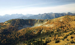
America's Best-Kept Secrets: Lake Chelan-Sawtooth Wilderness, WA
Feb 28, 2011 from backpacker.com
→ In An alpine park that’s as scenic—but not as stormy—as its famous neighbor ← OutNorth Cascades National Park’s fickle weather Hike...
Sub Regions
-
Angels Staircase / Uno Peak
- 3
- 18
- 13
- 1
-
Lookout Mountain
- 1
- 1
-
Loup Loup
- 3
- 11
- 2
-
Pipestone Canyon
- 5
- 3
- 1
Popular Twisp Mountain Biking Trails
• 95 ★ 4.5 • 6 miles • 2,075 ft • 494 •
The first mile descends through mixed Douglas fir and subalpine forest to the stream ford and then switches back, up for 0.75 miles and begins traveling above . At 4 miles the Martin Lake Trail goes off to the right. The route continues...
• 95 ★ 3.2 • 4,531 ft • 752 ft • 447 •
Typically ridden east to west when riding the Angel's Staircase loop. Channel your inner mountain goat to reach the false at the junction with Merchant's Basis #417.1. Once past the junction, the climb becomes manageable to humans up to...
• 95 ★ 4.2 • 2 miles • 147 ft • 436 •
Highly rated popular black diamond difficulty singletrack. This multi-use trail can be used both directions and has a moderate overall physical rating with a 147 ft double black diamond climb. On average it takes 33 minutes to complete this trail.
• 90 ★ 3.0 • 2 miles • 643 ft • 403 •
Once you've made the climb to access this trail, this makes for a great break on the legs. High alpine singletrack that wanders on the edges of the treeline and passing through gorgeous meadows. Note that the trail continues further in...
• 100 ★ 4.3 • 2 miles • 723 ft • 235 •
Climbing only trail to the top of with technical aspects.
• 100 ★ 5.0 • 3 miles • 9 ft • 228 •
is a blue descending trail packed to the brim with rock features, smaller to medium size hits, and some speedy sections for good measure. It rides through huge terrain and rock outcroppings, offering intermediate riders plenty of...
• 90 ★ 4.1 • 5 miles • 52 ft • 219 •
Fast and flowy single track downhill. Popular with motorcycles.
Twisp Mountain Bike Routes
★ 3.5 • 21 miles • 4,843 ft • 8 • Loop •
Angel's Staircase is a physically demanding, epic loop that takes you far from civilization, so bring...
★ 5.0 • 15 miles • 4,498 ft • 6 • Out & Back •
Epic ride with one of the best continuous descents you will ever do. Up Foggy, up Martin Creek, up Cooney...
★ 4.0 • 12 miles • 1,211 ft • 4 • Loop •
Mix of road with next to zero cars, double and singletrack through peaceful valleys. Not many surface...
★ 5.0 • 35 miles • 8,352 ft • 23 • Loop •
An alternative even more challenging series of trails that mirrors much of the famous Angels Staircase...
25 miles • 5,574 ft • 4 • Loop •
Climb up the road to the Left on the over to and then down .
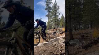
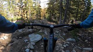
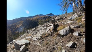
Photos of Twisp Mountain Bike
Videos of Twisp Mountain Bike
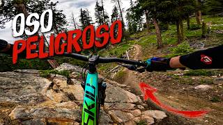
trail: Oso Peligroso
0:08 |
153 |
Aug 19, 2025
trail: Angels Staircase
9:16 |
584 |
Oct 11, 2020
trail: Eagle Lake Trail
5:12 |
20668 |
Jan 26, 2016
trail: Oso Peligroso
12:45 |
23 |
Jun 8, 2026 , Twisp
trail: Oh, Bother
0:32 |
207 |
Oct 31, 2025 , Twisp
trail: Foggy Dew Ridge
28:12 |
304 |
Oct 4, 2023 , Twisp
trail: Foggy Dew Ridge
2:30 |
218 |
Oct 3, 2023 , Twisp
trail: Martin Creek Trail
4:56 |
140 |
Oct 2, 2023 , Twisp
Current Trail Warnings
| status | trail | date | condition | user | info |
|---|---|---|---|---|---|
| Eagle Lake Trail | May 24, 2026 @ 2:43pm (America/Los_Angeles) May 24, 2026 | Snow Covered | vuke | 30+ downed trees of various size from the... |
Recent Trail Reports
| status | trail | date | condition | info | user |
|---|---|---|---|---|---|
| Ursus | Jun 13, 2026 @ 8:16am (America/Los_Angeles) Jun 13, 2026 | Ideal | Rbeukema | ||
| Telemark | Jun 13, 2026 @ 8:16am (America/Los_Angeles) Jun 13, 2026 | Ideal | Rbeukema | ||
| Lightning Creek | Jun 13, 2026 @ 8:16am (America/Los_Angeles) Jun 13, 2026 | Very Dry | Rbeukema | ||
| Bear Mountain Trail | Jun 13, 2026 @ 8:16am (America/Los_Angeles) Jun 13, 2026 | Dry | Rbeukema | ||
| Fozzie Bear Inventions | Jun 13, 2026 @ 8:16am (America/Los_Angeles) Jun 13, 2026 | Ideal | Rbeukema | ||
| Eclipse - FS 210 | Jun 13, 2026 @ 8:16am (America/Los_Angeles) Jun 13, 2026 | Ideal | Rbeukema | ||
| Gabion | Jun 13, 2026 @ 8:16am (America/Los_Angeles) Jun 13, 2026 | Unknown | Rbeukema | ||
| Oh, Bother | Jun 13, 2026 @ 8:16am (America/Los_Angeles) Jun 13, 2026 | Ideal | Rbeukema | ||
| Oso Peligroso | Jun 13, 2026 @ 8:16am (America/Los_Angeles) Jun 13, 2026 | Ideal | Rbeukema | ||
| Barely There | Jun 13, 2026 @ 8:16am (America/Los_Angeles) Jun 13, 2026 | Ideal | Rbeukema |
Activity Feed
| username | action | type | title | date |
|---|---|---|---|---|
| Ckareth | wishlist | trail | activity #97233460 | Jun 17, 2026 @ 10:42pm 17 hours |
| brucmc | ridden | trail | activity #97228642 | Jun 17, 2026 @ 8:07pm 20 hours |
| shadubya | wishlist | trail | activity #97137315 | Jun 16, 2026 @ 2:15pm 2 days |
| kyleiain | wishlist | region | activity #97059807 | Jun 15, 2026 @ 12:38pm Jun 15, 2026 |
| Stevemartinsen | wishlist | region | activity #97021984 | Jun 14, 2026 @ 9:10pm Jun 14, 2026 |
Recent Comments
| username | type | title | comment | date |
|---|---|---|---|---|
| trail | Absolute banger. Such a fun trail. | Jun 14, 2026 @ 1:03pm Jun 14, 2026 | ||
| trail | Seriously, one of the best trails I’ve... | Jun 11, 2026 @ 8:16pm Jun 11, 2026 | ||
| trail | Wow, what a trail! One of my new favorites... | Jun 8, 2026 @ 11:33am Jun 8, 2026 | ||
| trail | What a trail! Something for everyone rocks,... | May 18, 2026 @ 8:10am May 18, 2026 | ||
| trail | Early season ride: 1 small tree blowdown you... | Apr 29, 2026 @ 3:11pm Apr 29, 2026 |
Local Badges
-

10 Blue Trails17 awarded -

10 Black Trails4 awarded -

Epic Ride Climb 2k39 awarded -

Climbing 10k Badge9 awarded -

Climbing 100k Badge0 awarded -

Epic Ride Descent 2k133 awarded
Activity Type Stats
| activitytype | trails | distance | descent | descent distance | total vertical | rating | global rank | state rank | photos | reports | routes | ridelogs |
|---|---|---|---|---|---|---|---|---|---|---|---|---|
| Mountain Bike | 120 | 264 miles | 66,211 ft | 144 miles | 6,650 ft | #858 | #334 | 328 | 576 | 15 | 2,903 | |
| E-Bike | 77 | 203 miles | 53,074 ft | 108 miles | 6,650 ft | #680 | #749 | 443 | 4 | 201 | ||
| Horse | 62 | 194 miles | 39,209 ft | 72 miles | 7,756 ft | #142 | #392 | 173 | 1 | 1 | ||
| Hike | 173 | 465 miles | 98,832 ft | 198 miles | 7,756 ft | #254 | #129 | 2 | 554 | 13 | 1,026 | |
| Trail Running | 171 | 459 miles | 98,363 ft | 195 miles | 7,756 ft | #219 | #94 | 554 | 2 | 115 | ||
| Dirtbike/Moto | 41 | 159 miles | 39,117 ft | 87 miles | 6,106 ft | #160 | #98 | 215 | 1 | 75 | ||
| Observed Trials | 7 | 44 miles | 11,060 ft | 32 miles | 5,312 ft | #187 | #32 | 18 | ||||
| ATV/ORV/OHV | 7 | 44 miles | 11,060 ft | 32 miles | 5,312 ft | #521 | #184 | 133 | 1 | |||
| Snowshoe | 6 | 15 miles | 1,647 ft | 3 miles | 6,375 ft | #820 | #378 | 4 | 8 | |||
| Downhill Ski | 16 | 5 miles | 6,073 ft | 5 miles | 1,217 ft | #602 | #275 | 2 | 32 | |||
| Backcountry Ski | 4 | 11 miles | 423 ft | 4,068 ft | 5,627 ft | #489 | #124 | 3 | 141 | |||
| Nordic Ski | 14 | 26 miles | 2,677 ft | 12 miles | 810 ft | #711 | #259 | 4 | 182 |
Frequently Asked Questions About Twisp
▼
What are the best places to ride in Twisp?
Twisp has 8 areas to explore for mountain biking. The top rated areas are:
▼
What are the highest rated mountain biking trails in Twisp?
The highest rated mountain biking trails in Twisp are:
- Oso Peligroso (4.6/5)
- Telemark (4.6/5)
- Eagle Lake Trail (4.5/5)
- Oh, Bother (4.4/5)
- Fozzie Bear Inventions (4.3/5)
▼
What is the best time of the year to ride in Twisp?
Based on ride log data, the most popular months to ride in Twisp are:
- September (38 activities)
- July (25 activities)
- October (21 activities)
▼
Where can I park to ride in Twisp?
There are 26 parking locations listed in Twisp. The most popular parking spots are: View all parking and trailhead locations on the map to plan your visit.
Activities
Trails
Points of Interest
- Starvation Mountain Summit
- Fsih Creek Pass Summit
- Cooper Point Summit
- Cooper Pass Summit
- South Navarre Campground Camping
- North Navarre Peak Summit
- Silver Star Mountain Summit
- Hoodoo Peak Summit
- Martin Peak Summit
- Crescent Mine Sight
- North Gardner Mountain (8,914 ft)
- Gardner Mountain (8,911 ft)
- Oval Peak (8,743 ft)
- By ACree
 & contributors
 - Admins: EMBA-METHOW
- #6098 - 11,698 views
- twisp activity log | embed map of Twisp mountain bike trails | twisp mountain biking points of interest
Downloading of trail gps tracks in kml & gpx formats is enabled for Twisp.
You must login to download files.