5.1 miles
Distance
767 ft
Climb
-774 ft
Descent
967 ft
High Point

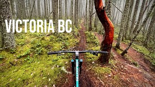
A fun blue starter, then up to Snakes & Ladders

Detailed Description
Down and Up is a 5 mile popular expert route located near Victoria British Columbia. This mountain bike only route can be used one direction and has a hard overall physical rating. This route includes 24 trails. This route climbs 767 ft with a max elevation of 967 ft then descends -774 ft.
Local Trail Association
Local trail association
South Island Mountain Bike Society (simbs.com)
Please consider joining or donating to the local riding association to support trail development & maintenance.
donate to earn trail karma!

26 Reviews & Comments

  • + 0
seanda (Sep 5, 2022 at 12:13)
Trail Rolly Ridge
@SIMBS. This trail is blue on the trail marker but black on trail forks. No matter which way I go down it it doesn’t count as a conpletionist badge. What gives?
[Reply]
  • + 3
sinding (May 22, 2022 at 20:15)
Trail Skull
Caution to folks riding this down; this is the primary climbing trail for most folks using the main parking lot. There are a few blind corners which can be dangerous for folks climbing and not expecting a rider.
[Reply]
  • + 0
renaudlafortune Sherbrooke (Apr 13, 2021 at 10:45)
Trail Ruffles
Optimal slabs Smile
[Reply]
  • + 1
Bottombrackets (Jan 24, 2021 at 9:08)
This access to the regional trail is not in CRD lands, it runs through private property and the trail are not maintained. Access to and from the regional trail is best from Robb Place.
[Reply]
  • + 0
IanKopp (Aug 21, 2020 at 22:28)
Top half has nice flowy corners and berms before more rock faces and technical features in the second half. Fantastic, classic and fun to ride in all conditions.
[Reply]
  • + 2
eh-steve (Jun 13, 2020 at 9:02)
Trail Twister
Why did the root on the corner after twister roll get removed? That was a technical feature. You had to get your line right (especially in the rain). Now it's easy. Boo. This is supposed to be a black trail right?
[Reply]
  • + 2
Caribou14 (Dec 2, 2019 at 14:08)
Trail Switchback
very hard to climb this trail clean. requires a very skilled rider. but very fun if you can make it to the top.
[Reply]
  • + 1
Caribou14 (Dec 2, 2019 at 14:06)
best trail ever
[Reply]
  • + 1
gregmowat (Nov 14, 2019 at 22:20)
Trail Switchback
This is no easy way up. Very tech climb.
[Reply]
  • + 0
RyanMacleod (Jun 24, 2019 at 6:54)
Trail Phase Two
Bylj
[Reply]
  • + 1
bpretty (Oct 14, 2018 at 9:39)
Thanks. Appreciated.
[Reply]
  • + 1
Dogride (Oct 14, 2018 at 9:11)
Nice work on the new route! It's clear you put a lot of time into it and it is great. Thanks!
[Reply]
  • + 0
TJPressello (May 21, 2018 at 17:08)
Trail Little Face
Sorry don’t know why it did that ment to be emojis
[Reply]
  • + 0
TJPressello (May 21, 2018 at 17:07)
Trail Little Face
One of my favorites. You have to go through a litter climb to get to it but after you do that its all downhill. Would recommend this to everyone in skill level. Just remember to use both brakes????????????????
[Reply]
  • + 1
3004 (Feb 2, 2018 at 20:51)
Fun trail to ride when you are finishing up.
[Reply]
  • + 2
SIMBSTrailsDirector SIMBS (Oct 9, 2017 at 15:57)
Thanks for your report - I will let the CRD know about the trees.
[Reply]
  • + 1
skinnypete (Oct 9, 2017 at 8:28)
Don't access this trail from the south end (Lakeridge Place Road). There are plenty of large trees down across the trail and it's not suitable for riding. Best to access the area from Robb Place when coming from the south.
[Reply]
  • + 1
SIMBSTrailsDirector SIMBS (Nov 20, 2016 at 6:22)
Looks like you are correct rossi45. 'Connector is a better name for this section of trail as Old Payoff is from Centerfold to the Regional Trail as indicated on the map. This also corresponds to the pier block trail markers in place which I verified Nov 18, 2016. Thank you for making the changes. Craig
[Reply]
  • + 2
rossi45 (Nov 17, 2016 at 16:28)
Not sure what your comment is supposed to explain? Are you saying this is not part of Old Payoff? Or are you saying this access points I detailed are wrong? What would the name of it be? There's no name on the paper map I bought 2 years ago. Someone had already added this trail and named it OP, but I went to edit it because the GPS track was significantly errored so that's where the name came from. Open Street map also has this trail named OP. I also thought there was a marker at the top saying it is OP when I was there last weekend. Please clarify your statement. Thanks.
[Reply]
  • + 1
SIMBSTrailsDirector SIMBS (Nov 18, 2016 at 4:43)
Don't remember seeing the 'connector' when I made my comment, just the name 'old payoff' which I thought was misleading because there is more to old payoff. thanks for the info though - I will check the marker also - we have some work to do to correct little dicrepancies between maps and markers so please let me know if you come accross them. you can post here or email me directly: [email protected]. craig
[Reply]
  • + 1
SIMBSTrailsDirector SIMBS (Nov 17, 2016 at 10:40)
The North end of Old Payoff is at the Regional trail. This is only part of OP. Craig SIMBS Trails C0-Director
[Reply]
Below threshold threads are hidden


Login or Sign Up to Comment

Details

  • Riding area
  • Primary Activity
    Mountain Bike
  • Difficulty rating
    Black Diamond
  • Route Type
    Loop
  • Bike type
    AM
  • Direction
    One Direction
  • Physical rating
    Hard
  • Ridelogs
    201
More Stats for Down and Up mountain bike route
  • Altitude min
    417 ft
  • Altitude start
    499 ft
  • Altitude end
    495 ft
  • Grade
    -0%
  • Grade max
    -42.3%
  • Grade min
    31.2%
  • Distance climb
    2 miles
  • Distance down
    2 miles
  • Distance flat
    5,230 ft
Avg: 2.25 (4 votes)
close
3D
Trail Conditions
  • Unknown
  • Snow Groomed
  • Snow Packed
  • Snow Covered
  • Snow Cover Inadequate
  • Freeze/thaw Cycle
  • Icy
  • Prevalent Mud
  • Wet
  • Variable
  • Ideal
  • Dry
  • Very Dry
Trail Flow (Ridden Direction)
Trailforks scans users ridelogs to determine the most popular direction each trail is ridden. A good flowing trail network will have most trails flowing in a single direction according to their intension.
The colour categories are based on what percentage of riders are riding a trail in its intended direction.
  • > 96%
  • > 90%
  • > 80%
  • > 70%
  • > 50%
  • < 50%
  • bi-directional trail
  • no data
Trail Last Ridden
Trailforks scans ridelogs to determine the last time a trail was ridden.
  • < 2 days
  • < 1 week
  • < 2 weeks
  • < 1 month
  • < 6 months
  • > 6 months
Trail Ridden Direction
The intended direction a trail should be ridden.
  • Downhill Only
  • Downhill Primary
  • Both Directions
  • Uphill Primary
  • Uphill Only
  • One Direction
Contribute Details
Colors indicate trail is missing specified detail.
  • Description
  • Photos
  • Description & Photos
  • Videos
Trail Popularity ?
Trailforks scans ridelogs to determine which trails are ridden the most in the last 9 months. Trails are compared with nearby trails in the same city region with a possible 25 colour shades. Think of this as a heatmap, more rides = more kinetic energy = warmer colors.
  • most popular
  • popular
  • less popular
  • not popular
ATV/ORV/OHV Filter
Max Vehicle Width
inches

Radar Time
x Activity Recordings
Trailforks users anonymized public ridelogs from the past 6 months.
  • mountain biking recent
  • mountain biking (>6 month)
  • hiking (1 year)
  • moto (1 year)
Activity Recordings
Trailforks users anonymized public skilogs from the past 12 months.
  • Downhill Ski
  • Backcountry Ski
  • Nordic Ski
  • Snowmobile
Jump Magnitude Heatmap
Heatmap of where riders jump on trails. Zoom in to see individual jumps, click circles to view jump details.
Trails Deemphasized
Trails are shown in grey.
disable
Only show trails with NO bikes.
enable

Save the current map location and zoom level as your default home location whenever this page is loaded.

Save
Trail transparency
26
206 | 1 comments | 1 faves
376
515 | 1 comments | 1 faves
Snake rolls
Snake rolls
89 | comments: 0 | favs:
Jul 20, 2022
Little Face to The Plunge Extension - Winter Ride
3:09 | 148 | comments: 0 | favs:
Dec 29, 2021

Recent Trail Reports Along Route

statustraildateconditiondescription
Ruffles
Mar 18, 2023 @ 2:01pm
Mar 18, 2023
Emergency Two
Mar 18, 2023 @ 2:00pm
Mar 18, 2023
Inventive
Mar 18, 2023 @ 1:59pm
Mar 18, 2023
Skull
Mar 18, 2023 @ 1:59pm
Mar 18, 2023
Shock Treatment
Mar 17, 2023 @ 12:41am
Mar 17, 2023
more reports »
  • By rncain & contributors
  • #5325 - 1,405 views