7.2 miles
Distance
1,796 ft
Climb
-1,782 ft
Descent
1,311 ft
High Point
11 ft
Altitude change
442 ft
Altitude min
446 ft
Altitude start
459 ft
Altitude end
-56.7%
Grade max
49.2%
Grade min
3 miles
Distance climb
3 miles
Distance down
1 mile
Distance flat

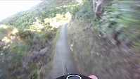
From the Mākara Peak carpark, climb to the summit via the iconic suspension bridge using Koru, Sally Alley, Upswing and Aratihi. After taking in the spectacular views from the Mākara Peak summit, descend via the Grade 3 fast and flowy tracks of either Peak Flow or North Face before re-entering the forest for Smokin, Big Tom’s Wheelie and SWIGG back to the carpark.

Detailed Description
Intermediate Loop is a 7 mile popular intermediate route located near Wellington. This mountain bike primary route can be used one direction and has a moderate overall physical rating. This route includes 3 trails. This route climbs 1,796 ft with a max elevation of 1,311 ft then descends -1,782 ft.
Route Supporters
Local Trail Association
Local trail association
Makara Peak MTB Park Supporters (www.makarapeak.org)
Please consider joining or donating to the local riding association to support trail development & maintenance.
Donate to earn trail karma!

Stats

  • Distance
    7 miles
  • Altitude min
    442 ft
  • Altitude start
    446 ft
  • Altitude end
    459 ft
  • Climb
    1,796 ft
  • Descent
    -1,782 ft
  • Grade max
    -56.7%
  • Grade min
    49.2%
  • Distance climb
    3 miles
  • Distance down
    3 miles
  • Distance flat
    1 mile

4 Reviews & Comments


We hope you've been enjoying Trailforks!

Create a FREE account to view route comments and much more.

Trails in Route

Details

  • Riding area
  • Primary Activity
    Mountain Bike
  • Other Activities
    • E-Bike
  • Difficulty rating
    Blue
  • Route Type
    Loop
  • eBike Allowed
  • Bike type
    AM, XC
  • Direction
    One Direction
  • Physical rating
    Moderate

Directions

  1. Walk west on Koru.
  2. Continue for 400 meters.
  3. Keep left to stay on Koru.
  4. Continue for 2 kilometers.
  5. Turn left onto Sally Alley.
  6. Continue for 800 meters.
  7. Turn right to stay on Sally Alley.
  8. Continue for 500 meters.
  9. Make a sharp right onto Tower 18 Connector.
  10. Continue for 40 meters.
  11. Turn left onto Three Brothers (Part 1).
  12. Continue for 400 meters.
no votes yet
close
3D
Trail Conditions
  • Unknown
  • Snow Groomed
  • Snow Packed
  • Snow Covered
  • Snow Cover Partial
  • Freeze/thaw Cycle
  • Icy
  • Prevalent Mud
  • Wet
  • Variable
  • Ideal
  • Dry
  • Very Dry
Trail Flow (Ridden Direction)
Trailforks scans users ridelogs to determine the most popular direction each trail is ridden. A good flowing trail network will have most trails flowing in a single direction according to their intension.
The colour categories are based on what percentage of riders are riding a trail in its intended direction.
  • > 96%
  • > 90%
  • > 80%
  • > 70%
  • > 50%
  • < 50%
  • bi-directional trail
  • no data
Trail Last Ridden
Trailforks scans ridelogs to determine the last time a trail was ridden.
  • < 2 days
  • < 1 week
  • < 2 weeks
  • < 1 month
  • < 6 months
  • > 6 months
Trail Ridden Direction
The intended direction a trail should be ridden.
  • Downhill Only
  • Downhill Primary
  • Both Directions
  • Uphill Primary
  • Uphill Only
  • One Direction
Contribute Details
Colors indicate trail is missing specified detail.
  • Description
  • Photos
  • Description & Photos
  • Videos
Trail Popularity ?
Trailforks scans ridelogs to determine which trails are ridden the most in the last 9 months. Trails are compared with nearby trails in the same city region with a possible 25 colour shades. Think of this as a heatmap, more rides = more kinetic energy = warmer colors.
  • most popular
  • popular
  • less popular
  • not popular
ATV/ORV/OHV Filter
Max Vehicle Width
inches
US Cell Coverage
Legend
cell carrier legend

Radar Time
Activity Recordings
Trailforks uses anonymized public activity data. ?
Activity Recordings
Trailforks uses anonymized public activity data. ?
Personal Heatmap
Activity Types
all / none
Options
2
Date range month
Winter Trails
Warning A routing network for winter maps does not exist. Selecting trails using the winter trails layer has been disabled.
Missing Trails
Most Popular
Least Popular
Trails are colored based on popularity. The more popular a trail is, the more red. Less popular trails trend towards green.
Jump Magnitude Heatmap
Heatmap of where riders jump on trails. Zoom in to see individual jumps, click circles to view jump details.
BC Backroad Status

Service Road Atlas is a free to use, community-driven service for viewing and creating reports on the numerous back-country service roads around B.C. and Alberta.

map legend
Slope Aspect
Direction the slope faces
Flat N NE E SE S SW W NW
Trails Deemphasized
Trails are shown in grey.
disable
Only show trails with no bike usage.
Enable
Suggested Layers
Based on selected activity type

    Save the current map location and zoom level as your default home location whenever this page is loaded.

    Save
    Trail transparency
    • Singletrack
    116
    108
    98
    80
    Last half of Sally Allley
    Last half of Sally Allley
    0:47 | 433 | comments: 0 | favs:
    Jun 5, 2016
    first dry weekend!

    Recent Trail Reports Along Route

    statustraildateconditiondescription
    Sally Alley
    Jun 28, 2026 @ 9:06am (Pacific/Auckland)
    2 days
    Wet. Very wet. Lots of branches down
    Three Brothers (Part 1)
    Jun 28, 2026 @ 9:06am (Pacific/Auckland)
    2 days
    Wet.
    Koru Shortcut
    Dec 27, 2025 @ 11:37am (Pacific/Auckland)
    Dec 26, 2025
    more reports »

    Hit the Trail

    Open in App

    Get this route on your phone instantly.

    Download Route

    Save to wishlist, Garmin & download.