
 Bridge
Open in App
Get this trail on your phone instantly.

Upswing is the new climbing track that provides a much easier and more enjoyable way of getting to the summit of Makara Peak compared with Missing Link or Snakecharmer.
The first part of the track was built in 2016 by volunteers and corporate work parties. It climbs at a pretty gentle gradient through a series of eight switchbacks before crossing the 72 metre long Wild At Heart suspension bridge. The suspension bridge was planned by the Makara Peak Supporters, who also raised the funds and coordinated volunteers to assist Abseil Access with the construction of the bridge.
The bridge crosses high above a steep sided gully and native bush. There are viewing platforms and picnic areas on both sides of the bridge where you can enjoy the views of the bridge and the centre of the park.
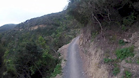
The second portion of the track continues at a mellow gradient around the valley before joining about three quarters of the way up Aratihi. This section of the trail was digger and rock breaker built by TGL Contracting with funding from the Wellington City Council.
From there riders can continue for another 10 minutes of climbing to the summit or choose to head into the south west corner of the park via Upper Leaping Lizard.
From the main carpark, head up Koru and Sally Alley. At the end of Sally Alley, turn right onto the 4WD track for 25m and then left onto Three Brothers . From St Albans Ave, head up Snake Charmer (4WD track) and drop into Sally Alley at one of the connector tracks.
| c1 | c2 | c3 | c4 |
|---|---|---|---|
January | February | March | April |
May | June | July | August |
September | October | November | December |

Service Road Atlas is a free to use, community-driven service for viewing and creating reports on the numerous back-country service roads around B.C. and Alberta.
Save the current map location and zoom level as your default home location whenever this page is loaded.
SaveWe hope you've been enjoying Trailforks!
Create a FREE account to view trail comments and much more.
You must enter a description before submitting.

