more stats
1.1 miles
Distance
92 ft
Climb
-433 ft
Descent
00:07:50
Avg time
-341 ft
Altitude change
966 ft
Altitude min
1,311 ft
Altitude max
1,307 ft
Altitude start
965 ft
Altitude end
-6%
Grade
-50.7%
Grade max
26.6%
Grade min
1,591 ft
Distance climb
3,169 ft
Distance down
955 ft
Distance flat
00:07:50
Avg time

Peak Flow Details

  • Activities
    • Mountain Bike
    • Hike
    • Trail Running
  • Riding Area
  • Difficulty Rating
  • Voted Difficulty
    Blue (4 votes)
  • Local Popularity
    90 in Mountain Biking [+]
    • 50 in Trail Running
    • 45 in Hiking
  • Global Ranking
    #162 in Mountain Biking [+]
    • #34863 in Trail Running
    • #37433 in Hiking
  • Trail Type
    Singletrack
  • Bike Type
    DH, AM, XC
  • Direction
    Downhill Only
    Popular Direction Shown
  • Physical Rating
    Easy
  • Dogs Allowed
    Yes
  • eBike Allowed
    Yes up to Class 1
  • TTFs on Trail
    Berm
  • Ride in Rain
    Yes
  • Year Opened
    2015
  • Land Owner

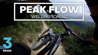
Peak Flow is a fairly wide digger-built flow track designed to be the easiest descent from the summit of Makara Peak in the direction of the main car park on South Karori Road.

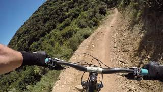
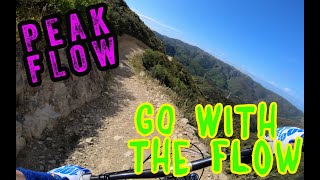
The first section of the track heads down from the summit over a couple of gentle rollers and berms before a short climb takes you to the high point on the track. From there it drops at a steady rate down the southern side of Makara Peak. The trail features well sculptured berms, rollers and small table tops to provide a fast and enjoyable style of track not found elsewhere on Makara Peak.

While Peak Flow is a grade 3 intermediate track, there's plenty of features to keep more highly skilled riders entertained or help riders continue to develop and progress their skills.

From the bottom of Peak Flow riders can continue on intermediate grade trails including Three Brothers, JFK, Smokin and Lazy Fern to the main car park or head back up to the summit for another run via Sally Alley and Upswing.

Access Info

From Makara Peak summit.

Trail Supporters
  • past supporters

Local Trail Association

Recent Activity on Trail

Past Week
  • 5 rides
  • 9 miles average
6 Months
  • 274 rides
  • 13 miles avg distance
All
  • 1,815 rides
  • Last: Jun 28, 2026
c1c2c3c4
January
February
March
April
May
June
July
August
September
October
November
December
update trails status or condition

Peak Flow Trail Reports

Status:
on Jun 23, 2026
Variable
Avg: 4.27 (39 votes)
Your vote: 0

view (22,812)
close
3D
Trail Conditions
  • Unknown
  • Snow Groomed
  • Snow Packed
  • Snow Covered
  • Snow Cover Partial
  • Freeze/thaw Cycle
  • Icy
  • Prevalent Mud
  • Wet
  • Variable
  • Ideal
  • Dry
  • Very Dry
Trail Flow (Ridden Direction)
Trailforks scans users ridelogs to determine the most popular direction each trail is ridden. A good flowing trail network will have most trails flowing in a single direction according to their intension.
The colour categories are based on what percentage of riders are riding a trail in its intended direction.
  • > 96%
  • > 90%
  • > 80%
  • > 70%
  • > 50%
  • < 50%
  • bi-directional trail
  • no data
Trail Last Ridden
Trailforks scans ridelogs to determine the last time a trail was ridden.
  • < 2 days
  • < 1 week
  • < 2 weeks
  • < 1 month
  • < 6 months
  • > 6 months
Trail Ridden Direction
The intended direction a trail should be ridden.
  • Downhill Only
  • Downhill Primary
  • Both Directions
  • Uphill Primary
  • Uphill Only
  • One Direction
Contribute Details
Colors indicate trail is missing specified detail.
  • Description
  • Photos
  • Description & Photos
  • Videos
Trail Popularity ?
Trailforks scans ridelogs to determine which trails are ridden the most in the last 9 months. Trails are compared with nearby trails in the same city region with a possible 25 colour shades. Think of this as a heatmap, more rides = more kinetic energy = warmer colors.
  • most popular
  • popular
  • less popular
  • not popular
ATV/ORV/OHV Filter
Max Vehicle Width
inches
US Cell Coverage
Legend
cell carrier legend

Radar Time
Activity Recordings
Trailforks uses anonymized public activity data. ?
Activity Recordings
Trailforks uses anonymized public activity data. ?
Personal Heatmap
Activity Types
all / none
Options
2
Date range month
Winter Trails
Warning A routing network for winter maps does not exist. Selecting trails using the winter trails layer has been disabled.
Missing Trails
Most Popular
Least Popular
Trails are colored based on popularity. The more popular a trail is, the more red. Less popular trails trend towards green.
Jump Magnitude Heatmap
Heatmap of where riders jump on trails. Zoom in to see individual jumps, click circles to view jump details.
BC Backroad Status

Service Road Atlas is a free to use, community-driven service for viewing and creating reports on the numerous back-country service roads around B.C. and Alberta.

map legend
Slope Aspect
Direction the slope faces
Flat N NE E SE S SW W NW
Trails Deemphasized
Trails are shown in grey.
disable
Only show trails with no bike usage.
Enable
Suggested Layers
Based on selected activity type

    Save the current map location and zoom level as your default home location whenever this page is loaded.

    Save
        Directions to peak-flow trailhead (-41.288660, 174.707230)

        Photos

        13 more »
        142 |
        Apr 27, 2021 @ 11:28pm
        Apr 27, 2021
        144 |
        Apr 27, 2021 @ 11:27pm
        Apr 27, 2021
        177 |
        Feb 16, 2020 @ 12:05am
        Feb 16, 2020
        153 |
        May 17, 2019 @ 3:19am
        May 17, 2019

        Videos

        27 more »
        youtuber YES, IT'S OPEN! - Peak Flow Mountain Bike...
        4:21 | 965 | Feb 17, 2021 , Wellington
        youtuber Peak Flow @ Makara Peak
        4:37 | 312 | Mar 10, 2018 , Wellington
        youtuber Peak Flow @ Makara Peak MTB Park
        4:43 | 342 | Jan 14, 2020 , Wellington
        Riding at Makara Peak Wellington.
        4:00 | 277 | Oct 25, 2023 , Wellington

        Trail Lists

        Routes with this trail

        7 miles 1,393 ft 15 Loop
        An easy loop that still goes up to the summit
        3.0 8 miles 1,356 ft 14 Loop
        Tired of and looking for an alternative to the usual intermediate or grade 3 lap of Makara Peak? Try...
        3 miles 257 ft 5 Point to Point
        This route features the best flow trails at Mākara Peak, starting with the most popular track in the park...

        8 Reviews & Comments


        We hope you've been enjoying Trailforks!

        Create a FREE account to view trail comments and much more.

        Frequently Asked Questions About Peak Flow

        Where is Peak Flow located?
        Peak Flow is located in Mākara Peak Mountain Bike Park, Wellington, New Zealand. It is part of the Mākara Peak Mountain Bike Park trail network. The trailhead is located at coordinates -41.28866, 174.70723.
        How hard is Peak Flow?
        Peak Flow is rated as Blue difficulty. The physical rating is Easy. The average grade is 6%.
        What is the elevation gain for Peak Flow?
        Peak Flow has 92 ft of elevation gain. The trail has 433 ft of elevation descent. The elevation ranges from 966 ft to 1,311 ft.
        Is Peak Flow a point to point trail?
        Yes, Peak Flow is a point to point trail. The direction is Downhill Only. The trail type is singletrack.

        Hit the Trail

        Open in App

        Get this trail on your phone instantly.
        open trail in app

        Download Trail

        Save to wishlist, Garmin & download.
        save the trail

        Find Related Routes

        Find routes and users activities that include this trail.
        find routes for this trail

        You must enter a description before submitting.