1,017 ft
Distance
-140 ft
Descent
00:01:56
Avg time
Supporters, Builders, Maintainers & Land Managers of Lumpy Pants Trail
  • SIMBS
    Sponsor
  • Fat Bastards
    Sponsor

Lumpy Pants Details

  • Activities
    • Mountain Bike
    • E-Bike
    • Hike
    • Trail Running
  • Riding Area
    Hartland Mountain Bike Park
    Victoria, British Columbia
  • Difficulty Rating
  • Voted Difficulty
    Black Diamond (7 votes)
  • Trail Type
    Singletrack
  • Bike Type
    DH, AM, XC
  • Direction
    Downhill Primary
  • Climb Difficulty
    Blue
  • Physical Rating
    Moderate
  • Trail Visibility
    Sometimes hard to follow
  • Dogs Allowed
    Yes
  • eBike Allowed
    Yes up to Class 1
  • TTFs on Trail
    Drop, Rock Face, Rock Garden
  • Ride in Rain
    Yes
  • Global Ranking
    #2807 in Mountain Biking [+]
    • #9059 in E-Biking
    • #26576 in Trail Running
    • #18353 in Hiking
  • Local Popularity
    95 in Mountain Biking [+]
    • 95 in E-Biking
    • 50 in Trail Running
    • 85 in Hiking
  • Land Owner
    Capital Regional District

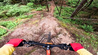
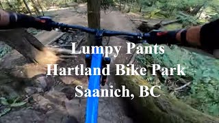
You can climb Lumpy Pants, but most ride this twisty trail down often after riding down Jelly Roll. There is a ride around, drop to transition, or rock roll option 1/3 of the way down.

Local Trail Association
More Stats for Lumpy Pants mountain bike trail trail
  • Altitude change
    -141 ft
  • Altitude min
    838 ft
  • Altitude max
    980 ft
  • Altitude start
    980 ft
  • Altitude end
    840 ft
  • Grade
    -13.9%
  • Grade max
    -34.4%
  • Grade min
    3.5%
  • Distance climb
    20 ft
  • Distance down
    860 ft
  • Distance flat
    92 ft
  • Avg time
    00:01:56
  • Avg reverse time
    00:06:40
  • view trail stats
Status:
on Apr 13, 2025
Ideal
Avg: 4.06 (24 votes)
Your vote: 0

view (12,456)
close
3D
Trail Conditions
  • Unknown
  • Snow Groomed
  • Snow Packed
  • Snow Covered
  • Snow Cover Partial
  • Freeze/thaw Cycle
  • Icy
  • Prevalent Mud
  • Wet
  • Variable
  • Ideal
  • Dry
  • Very Dry
Trail Flow (Ridden Direction)
Trailforks scans users ridelogs to determine the most popular direction each trail is ridden. A good flowing trail network will have most trails flowing in a single direction according to their intension.
The colour categories are based on what percentage of riders are riding a trail in its intended direction.
  • > 96%
  • > 90%
  • > 80%
  • > 70%
  • > 50%
  • < 50%
  • bi-directional trail
  • no data
Trail Last Ridden
Trailforks scans ridelogs to determine the last time a trail was ridden.
  • < 2 days
  • < 1 week
  • < 2 weeks
  • < 1 month
  • < 6 months
  • > 6 months
Trail Ridden Direction
The intended direction a trail should be ridden.
  • Downhill Only
  • Downhill Primary
  • Both Directions
  • Uphill Primary
  • Uphill Only
  • One Direction
Contribute Details
Colors indicate trail is missing specified detail.
  • Description
  • Photos
  • Description & Photos
  • Videos
Trail Popularity ?
Trailforks scans ridelogs to determine which trails are ridden the most in the last 9 months. Trails are compared with nearby trails in the same city region with a possible 25 colour shades. Think of this as a heatmap, more rides = more kinetic energy = warmer colors.
  • most popular
  • popular
  • less popular
  • not popular
ATV/ORV/OHV Filter
Max Vehicle Width
inches
US Cell Coverage
Legend
cell carrier legend

Radar Time
x Activity Recordings
Trailforks users anonymized public ridelogs from the past 6 months.
  • mountain biking recent
  • mountain biking (>6 month)
  • hiking (1 year)
  • moto (1 year)
Activity Recordings
Trailforks users anonymized public skilogs from the past 12 months.
  • Downhill Ski
  • Backcountry Ski
  • Nordic Ski
  • Snowmobile
Winter Trails
Warning A routing network for winter maps does not exist. Selecting trails using the winter trails layer has been disabled.
x Missing Trails
Most Popular
Least Popular
Trails are colored based on popularity. The more popular a trail is, the more red. Less popular trails trend towards green.
Jump Magnitude Heatmap
Heatmap of where riders jump on trails. Zoom in to see individual jumps, click circles to view jump details.
Trails Deemphasized
Trails are shown in grey.
disable
Only show trails with NO bikes.
enable

Save the current map location and zoom level as your default home location whenever this page is loaded.

Save
      Directions to lumpy-pants trailhead (48.538990, -123.477650)

      Recent Ridelog Activity on Trail

      Past Week
      • 19 rides
      • 9 miles avg distance
      6 Months
      • 293 rides
      • 8 miles avg distance
      All
      • 2,020 rides
      • Last: Apr 27, 2025

      Photos

      more »
      1,028 |
      Dec 11, 2014 @ 4:47pm
      Dec 11, 2014
      23 |
      Jan 25, 2023 @ 8:16pm
      Jan 25, 2023
      26 |
      Jan 25, 2023 @ 8:16pm
      Jan 25, 2023
      63 |
      Dec 29, 2022 @ 10:16am
      Dec 29, 2022

      2 Reviews & Comments


      We hope you've been enjoying Trailforks!

      Create a FREE account to view trail comments and much more.

      Videos

      more »
      BCBR 2024 - Stage 1 Preview
      1:9:43 | 64 | Jun 29, 2024 , Victoria
      Lumpy Pants at Hartland Bike Park, Saanich, BC
      0:45 | 132 | Nov 3, 2023 , Victoria
      Lumpy Pants - Hartland Bike Park: Psyched Out...
      2:45 | 444 | Apr 7, 2020 , Victoria
      Mt. Work - Lumpy Pants
      0:15 | 384 | Mar 28, 2019 , Victoria
      • By KZ-Powned & contributors
      • #1142 - 4,802 views

      You must enter a description before submitting.