

Open in App
Get this trail on your phone instantly.

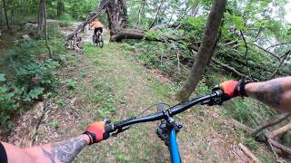
Mental H is a short but demanding double-black descent that branches left from Free Range roughly three-quarters of the way down.
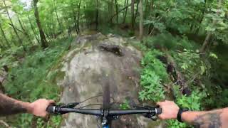
The trail begins along a peaceful loamy ridgeline before transitioning into an extended series of natural ledges, awkward rock moves, off-camber turns, punchy climbs, and technical line choices. Rather than one continuous rock slab, Mental H is a collection of broken ledge features that reward precision, balance, and commitment.
The centerpiece of the trail offers three feature options:
1) B-Line: A rocky chute bypass.
2) Ledge Line: Ride high along the exposed ledge before dropping back onto the trail.
3) Portal Line: Balance the spine of the ledge before descending a steep, chunky roller through a massive hollow hemlock root ball.
Midway through the trail, riders are rewarded with expansive views across Maple Wind Farm and South Richmond—but be aware that this viewpoint sits directly above a significant cliff.
While the trail is complete and fully rideable, expect it to continue evolving over time. Additional optional drops, alternate lines, and creative technical features may be added as the trail naturally develops.
Despite its double-black rating, no mandatory air is required anywhere on the trail. Most obstacles can be rolled with proper technique and careful line choice. While the exposure and technical terrain demand respect, Mental H was intentionally built as a place to develop natural rock-riding skills before progressing to larger and more committing technical trails found elsewhere in the region.
The trail finishes with one final technical rock roll before reconnecting with the Winner Winner Connector.
Advanced riders are encouraged, and confident intermediate riders with strong bike handling skills may also find it to be a rewarding progression trail if ridden cautiously. Significant cliff exposure exists in places, and mistakes can carry serious consequences. Ride within your ability.

| c1 | c2 | c3 | c4 |
|---|---|---|---|
January | February | March | April |
May | June | July | August |
September | October | November | December |

Service Road Atlas is a free to use, community-driven service for viewing and creating reports on the numerous back-country service roads around B.C. and Alberta.
Save the current map location and zoom level as your default home location whenever this page is loaded.
SaveWe hope you've been enjoying Trailforks!
Create a FREE account to view all trail reviews and much more.
 MWF & contributors
You must enter a description before submitting.

