more stats
5,194 ft
Distance
257 ft
Climb
-294 ft
Descent
00:08:13
Avg time
-37 ft
Altitude change
695 ft
Altitude min
820 ft
Altitude max
820 ft
Altitude start
784 ft
Altitude end
-0.7%
Grade
-35.4%
Grade max
47.4%
Grade min
2,480 ft
Distance climb
2,480 ft
Distance down
230 ft
Distance flat
00:08:13
Avg time

Missing Link Details

  • Activities
    • Mountain Bike
    • Hike
    • Trail Running
  • Riding Area
  • Difficulty Rating
  • Voted Difficulty
    Blue (4 votes)
  • Local Popularity
    75 in Mountain Biking [+]
    • 25 in Trail Running
    • 5 in Hiking
  • Global Ranking
    #21607 in Mountain Biking [+]
    • #116261 in Trail Running
    • #121341 in Hiking
  • Trail Type
    Singletrack
  • Bike Type
    AM, XC
  • Direction
    Both Directions
  • Climb Difficulty
    Blue
  • Physical Rating
    Moderate
  • Dogs Allowed
    Yes
  • eBike Allowed
    Yes up to Class 1
  • TTFs on Trail
    Bridge
  • Ride in Rain
    Yes
  • Year Opened
    1999
  • Land Owner
    Wellington City Council

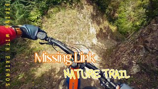
Old school singletrack that was one of the first built in the park by Makara Peak volunteers in 1998/1999.

It used to be the main singletrack route to the summit before Upswing was built. Is now largely left alone to age gracefully. Expect it to be narrow, rocky, pinch climbs, off camber and plenty of Makara rock.

Missing Link links the lower tracks to Aratihi, Leaping Lizard, Possum Track and Nikau Valley. It is narrow and has some nasty drop offs to be wary of. Most importantly Missing Link is a TWO WAY track so be careful on blind corners and ride like there is a walker / rider / elephant just around the corner.

Local Trail Association

Recent Activity on Trail

Past Week
  • 0 rides
  •  
6 Months
  • 43 rides
  • 16 miles avg distance
All
  • 761 rides
  • Last: Jun 21, 2026
c1c2c3c4
January
February
March
April
May
June
July
August
September
October
November
December
Status:
on Jun 19, 2026
Ideal
Avg: 4.13 (16 votes)
Your vote: 0

view (7,230)
close
3D
Trail Conditions
  • Unknown
  • Snow Groomed
  • Snow Packed
  • Snow Covered
  • Snow Cover Partial
  • Freeze/thaw Cycle
  • Icy
  • Prevalent Mud
  • Wet
  • Variable
  • Ideal
  • Dry
  • Very Dry
Trail Flow (Ridden Direction)
Trailforks scans users ridelogs to determine the most popular direction each trail is ridden. A good flowing trail network will have most trails flowing in a single direction according to their intension.
The colour categories are based on what percentage of riders are riding a trail in its intended direction.
  • > 96%
  • > 90%
  • > 80%
  • > 70%
  • > 50%
  • < 50%
  • bi-directional trail
  • no data
Trail Last Ridden
Trailforks scans ridelogs to determine the last time a trail was ridden.
  • < 2 days
  • < 1 week
  • < 2 weeks
  • < 1 month
  • < 6 months
  • > 6 months
Trail Ridden Direction
The intended direction a trail should be ridden.
  • Downhill Only
  • Downhill Primary
  • Both Directions
  • Uphill Primary
  • Uphill Only
  • One Direction
Contribute Details
Colors indicate trail is missing specified detail.
  • Description
  • Photos
  • Description & Photos
  • Videos
Trail Popularity ?
Trailforks scans ridelogs to determine which trails are ridden the most in the last 9 months. Trails are compared with nearby trails in the same city region with a possible 25 colour shades. Think of this as a heatmap, more rides = more kinetic energy = warmer colors.
  • most popular
  • popular
  • less popular
  • not popular
ATV/ORV/OHV Filter
Max Vehicle Width
inches
US Cell Coverage
Legend
cell carrier legend

Radar Time
Activity Recordings
Trailforks uses anonymized public activity data. ?
Activity Recordings
Trailforks uses anonymized public activity data. ?
Personal Heatmap
Activity Types
all / none
Options
2
Date range month
Winter Trails
Warning A routing network for winter maps does not exist. Selecting trails using the winter trails layer has been disabled.
Missing Trails
Most Popular
Least Popular
Trails are colored based on popularity. The more popular a trail is, the more red. Less popular trails trend towards green.
Jump Magnitude Heatmap
Heatmap of where riders jump on trails. Zoom in to see individual jumps, click circles to view jump details.
BC Backroad Status

Service Road Atlas is a free to use, community-driven service for viewing and creating reports on the numerous back-country service roads around B.C. and Alberta.

map legend
Slope Aspect
Direction the slope faces
Flat N NE E SE S SW W NW
Trails Deemphasized
Trails are shown in grey.
disable
Only show trails with no bike usage.
Enable
Suggested Layers
Based on selected activity type

    Save the current map location and zoom level as your default home location whenever this page is loaded.

    Save
        Directions to missing-link-17894 trailhead (-41.296610, 174.710460)

        Photos

        0 more »
        18 |
        Feb 17, 2026 @ 6:56pm
        Feb 17, 2026
        23 |
        Feb 17, 2026 @ 6:56pm
        Feb 17, 2026

        Videos

        2 more »
        Missing Link - Grade 4 Trail at Makara Peak...
        9:32 | 195 | Feb 24, 2024 , Wellington
        Missing Link - Makara Peak, Wellington
        3:05 | 525 | May 13, 2015 , Wellington

        Routes with this trail

        4.8 5 miles 1,484 ft 5 Point to Point
        This climb used to be the primary singletrack route to the summit prior to and the suspension bridge being...
        5.0 6 miles 1,489 ft 16 Loop
        An Advanced grade loop taking you out to the wilds of Makara Peak. Harder than an Intermediate grade due...
        4 miles 1,569 ft 9 Point to Point
        Alternative grade 4 (advanced) route to the summit from the end of . Taking in , the top of and and it...

        6 Reviews & Comments


        We hope you've been enjoying Trailforks!

        Create a FREE account to view trail comments and much more.

        Frequently Asked Questions About Missing Link

        Where is Missing Link located?
        Missing Link is located in Mākara Peak Mountain Bike Park, Wellington, New Zealand. It is part of the Mākara Peak Mountain Bike Park trail network. The trailhead is located at coordinates -41.29661, 174.71046.
        How hard is Missing Link?
        Missing Link is rated as Advanced difficulty. The physical rating is Moderate. The average grade is 0.7%. The climb difficulty is rated Blue.
        What is the elevation gain for Missing Link?
        Missing Link has 78 m of elevation gain. The trail has 90 m of elevation descent. The elevation ranges from 212 m to 250 m.
        Is Missing Link a point to point trail?
        Missing Link is not a point to point trail. The direction is Both Directions. The trail type is singletrack.

        Hit the Trail

        Open in App

        Get this trail on your phone instantly.
        open trail in app

        Download Trail

        Save to wishlist, Garmin & download.
        save the trail

        Find Related Routes

        Find routes and users activities that include this trail.
        find routes for this trail

        You must enter a description before submitting.