1,798 ft
Distance
-106 ft
Descent
00:04:18
Avg time
Supporters, Builders, Maintainers & Land Managers of Roadside Attraction Trail

Roadside Attraction Details

  • Activities
    • Mountain Bike
    • Hike
    • Trail Running
  • Riding Area
    Mount Fromme
    North Vancouver, British Columbia
  • Difficulty Rating
  • Voted Difficulty
    Green (3 votes)
  • Trail Type
    Singletrack
  • Bike Type
    DH, AM, XC
  • Direction
    Both Directions
  • Climb Difficulty
    Blue
  • Physical Rating
    Easy
  • Season
    year round
  • Dogs Allowed
    Yes
  • TTFs on Trail
    Bridge
  • Ride in Rain
    Yes
  • Global Ranking
    #1036 in Mountain Biking [+]
    • #273 in Trail Running
    • #478 in Hiking
  • Land Owner
    District of North Vancouver

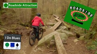
Short trail that is the first trail for many new riders. Has a mixture of features that make a good introduction to north shore riding, such a board walk and some rooty sections. Can be ridden in both directions, but keep an eye out for new riders, dog walkers, and kids on push bikes if riding up. Once you are comfortable with Roadside, Bobsled is a popular next trail to progress to. King of the Shore is also a good trail to progress to, but will force the beginning rider to either turn around and ride back up, or exit on McNair drive and ride up the road.

Access Info

Accessed from the 1st switchback or the water tower.

Local Trail Association
More Stats for Roadside Attraction multi-use trail trail
  • Altitude change
    -106 ft
  • Altitude min
    1,139 ft
  • Altitude max
    1,247 ft
  • Altitude start
    1,246 ft
  • Altitude end
    1,138 ft
  • Grade
    -5.9%
  • Grade max
    -20.7%
  • Grade min
    1.4%
  • Distance climb
    52 ft
  • Distance down
    1,699 ft
  • Distance flat
    46 ft
  • Avg time
    00:04:18
  • Avg reverse time
    00:05:42
  • view trail stats
Status:
on Mar 26, 2023
Variable
Avg: 3.1 (34 votes)
Your vote: 0

view (6)
close
3D
Trail Conditions
  • Unknown
  • Snow Groomed
  • Snow Packed
  • Snow Covered
  • Snow Cover Inadequate
  • Freeze/thaw Cycle
  • Icy
  • Prevalent Mud
  • Wet
  • Variable
  • Ideal
  • Dry
  • Very Dry
Trail Flow (Ridden Direction)
Trailforks scans users ridelogs to determine the most popular direction each trail is ridden. A good flowing trail network will have most trails flowing in a single direction according to their intension.
The colour categories are based on what percentage of riders are riding a trail in its intended direction.
  • > 96%
  • > 90%
  • > 80%
  • > 70%
  • > 50%
  • < 50%
  • bi-directional trail
  • no data
Trail Last Ridden
Trailforks scans ridelogs to determine the last time a trail was ridden.
  • < 2 days
  • < 1 week
  • < 2 weeks
  • < 1 month
  • < 6 months
  • > 6 months
Trail Ridden Direction
The intended direction a trail should be ridden.
  • Downhill Only
  • Downhill Primary
  • Both Directions
  • Uphill Primary
  • Uphill Only
  • One Direction
Contribute Details
Colors indicate trail is missing specified detail.
  • Description
  • Photos
  • Description & Photos
  • Videos
Trail Popularity ?
Trailforks scans ridelogs to determine which trails are ridden the most in the last 9 months. Trails are compared with nearby trails in the same city region with a possible 25 colour shades. Think of this as a heatmap, more rides = more kinetic energy = warmer colors.
  • most popular
  • popular
  • less popular
  • not popular
ATV/ORV/OHV Filter
Max Vehicle Width
inches

Radar Time
x Activity Recordings
Trailforks users anonymized public ridelogs from the past 6 months.
  • mountain biking recent
  • mountain biking (>6 month)
  • hiking (1 year)
  • moto (1 year)
Activity Recordings
Trailforks users anonymized public skilogs from the past 12 months.
  • Downhill Ski
  • Backcountry Ski
  • Nordic Ski
  • Snowmobile
Jump Magnitude Heatmap
Heatmap of where riders jump on trails. Zoom in to see individual jumps, click circles to view jump details.
Trails Deemphasized
Trails are shown in grey.
disable
Only show trails with NO bikes.
enable

Save the current map location and zoom level as your default home location whenever this page is loaded.

Save
      Directions to roadside-attraction trailhead (49.363310, -123.039210)
      update trails status or condition

      Roadside Attraction Trail Reports

      Recent Ridelog Activity on Trail

      Past Week
      • 40 rides
      • 6 miles avg distance
      6 Months
      • 735 rides
      • 7 miles avg distance
      All
      • 31,068 rides
      • Last: Mar 28, 2023

      Photos

      more »
      159 |
      Jan 18, 2021 @ 3:44pm
      Jan 18, 2021
      114 |
      Nov 27, 2020 @ 10:04pm
      Nov 27, 2020
      111 |
      Oct 14, 2020 @ 3:04pm
      Oct 14, 2020
      191 |
      Jan 27, 2020 @ 4:34pm
      Jan 27, 2020

      4 Reviews & Comments


      We hope you've been enjoying Trailforks!

      Create a FREE account to view trail comments and much more.

      Videos

      more »
      youtuber ENDURO MTB RACING THE NORTH SHORE !? // NSMBA...
      10:55 | 536 | May 6, 2019 , North Vancouver
      youtuber ROADSIDE ATTRACTION: North Shore: Trail Review
      3:59 | 317 | Apr 16, 2022 , North Vancouver
      youtuber Can an 8 year old ride...  Roadside Attraction...
      3:21 | 1070 | Feb 19, 2019 , North Vancouver
      youtuber Mt. Fromme - Roadside Attraction
      3:01 | 1336 | Sep 30, 2018 , North Vancouver
      • subscribe
      • flag
      • login to download gpx or kml files.