1.7 miles
Distance
73 ft
Climb
-95 ft
Descent
00:12:05
Avg time

Sandmans Details

  • Activities
    • Mountain Bike
    • E-Bike
    • Hike
    • Trail Running
    • Backcountry Ski
    • Nordic Ski
  • Riding Area
    Catamount Outdoor Family Center
    Williston, Vermont
  • Difficulty Rating
  • Hiking SAC Scale
    T1 Hiking
  • Trail Type
    Dirt/Gravel Road
  • Snow Grooming
    Classic / Skating
  • Bike Type
    AM, XC, Fat, Adaptive MTB, Gravel
  • Direction
    Both Directions
  • Climb Difficulty
    Green
  • Physical Rating
    Easy
  • Trail Visibility
    Always easy to follow
  • eBike Allowed
    Yes up to Class 1
  • Local Popularity
    60 in Mountain Biking [+]
    • 5 in E-Biking
    • 85 in Trail Running
    • 100 in Hiking
    • 5 in Skiing
    • 100 in Skiing
  • Land Owner
    Town of Williston, Vermont

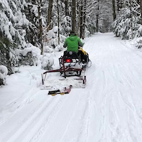
Flagship multi-use gravel track. Winter skiing, summer biking and running, adaptive-friendly and GREAT for jog strollers. Used heavily to access single tracks or great just as a loop. Access via Wood's Trace from the parking lot

Local Trail Association
Traditionally Indigenous Territory
More Stats for Sandmans multi-use trail trail
  • Altitude change
    -21 ft
  • Altitude min
    506 ft
  • Altitude max
    562 ft
  • Altitude start
    541 ft
  • Altitude end
    522 ft
  • Grade
    -0.2%
  • Grade max
    -10.1%
  • Grade min
    7%
  • Distance climb
    1,952 ft
  • Distance down
    2,116 ft
  • Distance flat
    5,030 ft
  • Avg time
    00:12:05
  • Avg reverse time
    00:21:49
  • view trail stats
Status:
on Mar 15, 2025
Snow Groomed
Avg: 4.24 (2 votes)
Your vote: 0

view (926)
close
3D
Trail Conditions
  • Unknown
  • Snow Groomed
  • Snow Packed
  • Snow Covered
  • Snow Cover Partial
  • Freeze/thaw Cycle
  • Icy
  • Prevalent Mud
  • Wet
  • Variable
  • Ideal
  • Dry
  • Very Dry
Trail Flow (Ridden Direction)
Trailforks scans users ridelogs to determine the most popular direction each trail is ridden. A good flowing trail network will have most trails flowing in a single direction according to their intension.
The colour categories are based on what percentage of riders are riding a trail in its intended direction.
  • > 96%
  • > 90%
  • > 80%
  • > 70%
  • > 50%
  • < 50%
  • bi-directional trail
  • no data
Trail Last Ridden
Trailforks scans ridelogs to determine the last time a trail was ridden.
  • < 2 days
  • < 1 week
  • < 2 weeks
  • < 1 month
  • < 6 months
  • > 6 months
Trail Ridden Direction
The intended direction a trail should be ridden.
  • Downhill Only
  • Downhill Primary
  • Both Directions
  • Uphill Primary
  • Uphill Only
  • One Direction
Contribute Details
Colors indicate trail is missing specified detail.
  • Description
  • Photos
  • Description & Photos
  • Videos
Trail Popularity ?
Trailforks scans ridelogs to determine which trails are ridden the most in the last 9 months. Trails are compared with nearby trails in the same city region with a possible 25 colour shades. Think of this as a heatmap, more rides = more kinetic energy = warmer colors.
  • most popular
  • popular
  • less popular
  • not popular
ATV/ORV/OHV Filter
Max Vehicle Width
inches
US Cell Coverage
Legend
cell carrier legend

Radar Time
x Activity Recordings
Trailforks users anonymized public ridelogs from the past 6 months.
  • mountain biking recent
  • mountain biking (>6 month)
  • hiking (1 year)
  • moto (1 year)
Activity Recordings
Trailforks users anonymized public skilogs from the past 12 months.
  • Downhill Ski
  • Backcountry Ski
  • Nordic Ski
  • Snowmobile
Winter Trails
Warning A routing network for winter maps does not exist. Selecting trails using the winter trails layer has been disabled.
x Missing Trails
Most Popular
Least Popular
Trails are colored based on popularity. The more popular a trail is, the more red. Less popular trails trend towards green.
Jump Magnitude Heatmap
Heatmap of where riders jump on trails. Zoom in to see individual jumps, click circles to view jump details.
Trails Deemphasized
Trails are shown in grey.
disable
Only show trails with NO bikes.
enable

Save the current map location and zoom level as your default home location whenever this page is loaded.

Save
      Directions to sandmans trailhead (44.452770, -73.047910)
      update trails status or condition

      Sandmans Trail Reports

      Recent Ridelog Activity on Trail

      Past Week
      • 0 rides
      •  
      6 Months
      • 6 rides
      • 6 miles avg distance
      All
      • 90 rides
      • Last: Apr 15, 2025

      Photos

      more »
      137 |
      Jun 6, 2021 @ 2:14pm
      Jun 6, 2021
      17 |
      Feb 9, 2019 @ 2:24pm
      Feb 9, 2019
      143 |
      Jun 22, 2018 @ 3:14pm
      Jun 22, 2018
      18 |
      Jan 4, 2024 @ 4:01am
      Jan 4, 2024

      Routes with this trail

      more »
      titledistance
      Goose Hill Groomed Ski- Red arrows2 miles
      2016 Race - Blue on White race3 miles
      2017 Race - Yellow on green race3 miles
      2017 Race - Red on back race4 miles

      Reviews / Comments

      No reviews yet, be the first to write a review or ask a question.
      Use trail reports to comment on trail conditions.


      We hope you've been enjoying Trailforks!

      Create a FREE account to view trail comments and much more.

      Videos

      more »
      17 | Apr 23, 2021 , Williston
      • By StephaneMarceauTF Pro TRAILFORKS & contributors
      • #40878 - 1,244 views

      You must enter a description before submitting.