2,021 ft
Distance
-201 ft
Descent
00:07:00
Avg time

Show Time Details

  • Activities
    • Mountain Bike
    • E-Bike
    • Hike
    • Trail Running
  • Riding Area
    Mount Tzouhalem
    Duncan, British Columbia
  • Difficulty Rating
  • Hiking SAC Scale
    T2 Mountain Hiking
  • Trail Type
    Singletrack
  • Direction
    Downhill Primary
    Popular direction shown
  • Dogs Allowed
    Yes
  • eBike Allowed
    Yes up to Class 1
  • TTFs on Trail
    Drop, Other
  • Global Ranking
    #72590 in Mountain Biking [+]
    • #8397 in E-Biking
    • #47347 in Trail Running
    • #26456 in Hiking
  • Local Popularity
    85 in Mountain Biking [+]
    • 90 in E-Biking
    • 50 in Trail Running
    • 40 in Hiking
  • Land Owner
    Municipality of North Cowichan

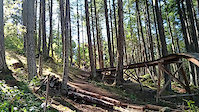
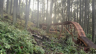
This section of Showtime used to be called Upper T. Old school cross country that starts out downhill and then changes in to a technical trail with hard climbs as you near the Showtime drop. Often people exit at the connector opposite to where Cakewalk hits T-Road

Local Trail Association
More Stats for Show Time mountain bike trail trail
  • Altitude change
    -201 ft
  • Altitude min
    1,310 ft
  • Altitude max
    1,511 ft
  • Altitude start
    1,511 ft
  • Altitude end
    1,309 ft
  • Grade
    -10%
  • Grade max
    -29.9%
  • Grade min
    -0.6%
  • Distance down
    1,985 ft
  • Distance flat
    33 ft
  • Avg time
    00:07:00
  • Avg reverse time
    00:09:57
  • view trail stats
Status:
on Dec 12, 2024
Wet
Avg: 3.62 (10 votes)
Your vote: 0

view (2,210)
close
3D
Trail Conditions
  • Unknown
  • Snow Groomed
  • Snow Packed
  • Snow Covered
  • Snow Cover Partial
  • Freeze/thaw Cycle
  • Icy
  • Prevalent Mud
  • Wet
  • Variable
  • Ideal
  • Dry
  • Very Dry
Trail Flow (Ridden Direction)
Trailforks scans users ridelogs to determine the most popular direction each trail is ridden. A good flowing trail network will have most trails flowing in a single direction according to their intension.
The colour categories are based on what percentage of riders are riding a trail in its intended direction.
  • > 96%
  • > 90%
  • > 80%
  • > 70%
  • > 50%
  • < 50%
  • bi-directional trail
  • no data
Trail Last Ridden
Trailforks scans ridelogs to determine the last time a trail was ridden.
  • < 2 days
  • < 1 week
  • < 2 weeks
  • < 1 month
  • < 6 months
  • > 6 months
Trail Ridden Direction
The intended direction a trail should be ridden.
  • Downhill Only
  • Downhill Primary
  • Both Directions
  • Uphill Primary
  • Uphill Only
  • One Direction
Contribute Details
Colors indicate trail is missing specified detail.
  • Description
  • Photos
  • Description & Photos
  • Videos
Trail Popularity ?
Trailforks scans ridelogs to determine which trails are ridden the most in the last 9 months. Trails are compared with nearby trails in the same city region with a possible 25 colour shades. Think of this as a heatmap, more rides = more kinetic energy = warmer colors.
  • most popular
  • popular
  • less popular
  • not popular
ATV/ORV/OHV Filter
Max Vehicle Width
inches
US Cell Coverage
Legend
cell carrier legend

Radar Time
x Activity Recordings
Trailforks users anonymized public ridelogs from the past 6 months.
  • mountain biking recent
  • mountain biking (>6 month)
  • hiking (1 year)
  • moto (1 year)
Activity Recordings
Trailforks users anonymized public skilogs from the past 12 months.
  • Downhill Ski
  • Backcountry Ski
  • Nordic Ski
  • Snowmobile
Winter Trails
Warning A routing network for winter maps does not exist. Selecting trails using the winter trails layer has been disabled.
x Missing Trails
Most Popular
Least Popular
Trails are colored based on popularity. The more popular a trail is, the more red. Less popular trails trend towards green.
Jump Magnitude Heatmap
Heatmap of where riders jump on trails. Zoom in to see individual jumps, click circles to view jump details.
Trails Deemphasized
Trails are shown in grey.
disable
Only show trails with NO bikes.
enable

Save the current map location and zoom level as your default home location whenever this page is loaded.
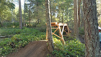
Save
      Directions to show-time trailhead (48.780360, -123.619300)
      update trails status or condition

      Show Time Trail Reports

      Recent Ridelog Activity on Trail

      Past Week
      • 1 rides
      • 9.1 km avg distance
      6 Months
      • 52 rides
      • 14.0 km avg distance
      All
      • 395 rides
      • Last: Jan 19, 2025

      Photos

      more »
      366 |
      Dec 21, 2020 @ 3:00pm
      Dec 21, 2020
      246 |
      Dec 20, 2020 @ 9:01pm
      Dec 20, 2020
      2 |
      Nov 23, 2024 @ 12:55pm
      Nov 23, 2024
      78 |
      Aug 28, 2022 @ 8:20am
      Aug 28, 2022

      Routes with this trail

      titledistance
      Chicken and DD9 miles

      1 Review & Comments


      We hope you've been enjoying Trailforks!

      Create a FREE account to view trail comments and much more.

      Videos

      more »
      Tobias and Roy himself on Roy's Roll
      161 | Sep 25, 2022 , Duncan
      Friday Fails Crash
      1320 | Jan 15, 2021 , Duncan
      Roy's Roll on Show Time
      495 | Dec 24, 2020 , Duncan
      OOPS
      0:20 | 1572 | Jul 2, 2015 , Duncan
      • By Tekmisfit & contributors
      • #2529 - 4,166 views

      You must enter a description before submitting.