more stats
2.8 miles
Distance
21 ft
Climb
-2,120 ft
Descent
00:23:19
Avg time
-2,099 ft
Altitude change
4,263 ft
Altitude min
6,362 ft
Altitude max
6,362 ft
Altitude start
4,262 ft
Altitude end
-14.4%
Grade
-95.6%
Grade max
4.9%
Grade min
505 ft
Distance climb
3 miles
Distance down
118 ft
Distance flat
00:23:19
Avg time

Summit Details

  • Activities
    • Mountain Bike
    • E-Bike
    • Hike
    • Trail Running
  • Riding Area
    Mount 7
    Golden, British Columbia
  • Difficulty Rating
  • Local Popularity
    35 in Mountain Biking [+]
    • 50 in E-Biking
    • 5 in Trail Running
    • 5 in Hiking
  • Global Ranking
    #117491 in Mountain Biking [+]
    • #78983 in E-Biking
    • #124619 in Trail Running
    • #245943 in Hiking
  • Trail Type
    Singletrack
  • Bike Type
    DH, AM
  • Direction
    Downhill Only
    Popular Direction Shown
  • eBike Allowed

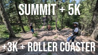
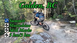
A long and flowy traverse contouring from the summit launch to just below the B12 start point. A true classic, Summit makes for an excellent run for anyone unsure about taking on the challenging downhill descents that otherwise brand the mountain. WATCH OUT: the bottom 100m of Summit trail is a an old skid road which is shared use with motorized riders - watch for them on that section.

Start from the Mt 7 summit launch below the memorial site., just to the left of the gazebo. There are a few quick corners before dropping below an old cabin and into a fast sidehill decent. Note, there is an alternate entrance starting right out of the parking lot at the old cabin.

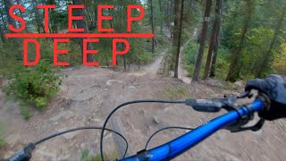
After the major switchback just past the cabin, you reach your first junction. Branch right to stay on Summit (Moonshine continues on the left). Continuing down you’ll pass the lefthand entrance onto 10K. Enjoy great views throughout the trail, particularly from the launch site. Be sure to watch for steep exposure as the trail flows across several steep sidehills.

A section of double track jeep road brings you to a crossing of the Bowle-Evans Forest Service Road (keep an eye open for vehicle traffic). From here you continue across the road where Summit continues as single track (as of 2022). Alternatively you can head down the dusty road to the Schacher or 5K trails.

The 2022 extension of Summit is filled with some jumps and rolls. This trail leads into Schacher, and from there you can continue up or down Schacher, or take B52 over to 5K.

Local Trail Association
Traditionally Indigenous Territory

Recent Activity on Trail

Past Week
  • 0 rides
  •  
6 Months
  • 0 rides
  •  
All
  • 64 rides
  • Last: Oct 5, 2025
c1c2c3c4
January
February
March
April
May
June
July
August
September
October
November
December
update trails status or condition

Summit Trail Reports

statusdatedescription
May 22, 2026 @ 3:23pm (America/Edmonton)
May 22, 2026
reporter
May 7, 2026 @ 6:59pm (America/Edmonton)
May 7, 2026
reporter Clear below the top of Moonshine
Mar 30, 2026 @ 8:01pm (America/Edmonton)
Mar 30, 2026
reporter The trail crew will open trails as they are assessed. Thanks.
Sep 4, 2025 @ 8:32pm
Sep 4, 2025
In good shape, couple of moon dust sections adds to the fun
May 25, 2025 @ 5:42pm
May 25, 2025
reporter
more »
Status:
on May 22, 2026
Variable
Avg: 3.84 (7 votes)
Your vote: 0

view (496)
close
3D
Trail Conditions
  • Unknown
  • Snow Groomed
  • Snow Packed
  • Snow Covered
  • Snow Cover Partial
  • Freeze/thaw Cycle
  • Icy
  • Prevalent Mud
  • Wet
  • Variable
  • Ideal
  • Dry
  • Very Dry
Trail Flow (Ridden Direction)
Trailforks scans users ridelogs to determine the most popular direction each trail is ridden. A good flowing trail network will have most trails flowing in a single direction according to their intension.
The colour categories are based on what percentage of riders are riding a trail in its intended direction.
  • > 96%
  • > 90%
  • > 80%
  • > 70%
  • > 50%
  • < 50%
  • bi-directional trail
  • no data
Trail Last Ridden
Trailforks scans ridelogs to determine the last time a trail was ridden.
  • < 2 days
  • < 1 week
  • < 2 weeks
  • < 1 month
  • < 6 months
  • > 6 months
Trail Ridden Direction
The intended direction a trail should be ridden.
  • Downhill Only
  • Downhill Primary
  • Both Directions
  • Uphill Primary
  • Uphill Only
  • One Direction
Contribute Details
Colors indicate trail is missing specified detail.
  • Description
  • Photos
  • Description & Photos
  • Videos
Trail Popularity ?
Trailforks scans ridelogs to determine which trails are ridden the most in the last 9 months. Trails are compared with nearby trails in the same city region with a possible 25 colour shades. Think of this as a heatmap, more rides = more kinetic energy = warmer colors.
  • most popular
  • popular
  • less popular
  • not popular
ATV/ORV/OHV Filter
Max Vehicle Width
inches
US Cell Coverage
Legend
cell carrier legend

Radar Time
Activity Recordings
Trailforks uses anonymized public activity data. ?
Activity Recordings
Trailforks uses anonymized public activity data. ?
Personal Heatmap
Activity Types
all / none
Options
2
Date range month
Winter Trails
Warning A routing network for winter maps does not exist. Selecting trails using the winter trails layer has been disabled.
Missing Trails
Most Popular
Least Popular
Trails are colored based on popularity. The more popular a trail is, the more red. Less popular trails trend towards green.
Jump Magnitude Heatmap
Heatmap of where riders jump on trails. Zoom in to see individual jumps, click circles to view jump details.
BC Backroad Status

Service Road Atlas is a free to use, community-driven service for viewing and creating reports on the numerous back-country service roads around B.C. and Alberta.

map legend
Slope Aspect
Direction the slope faces
Flat N NE E SE S SW W NW
Trails Deemphasized
Trails are shown in grey.
disable
Only show trails with no bike usage.
Enable
Suggested Layers
Based on selected activity type

    Save the current map location and zoom level as your default home location whenever this page is loaded.

    Save
        Directions to summit trailhead (51.275600, -116.885300)

        Photos

        4 more »
        560 |
        Aug 30, 2017 @ 6:46pm
        Aug 30, 2017
        428 |
        Aug 20, 2016 @ 7:11pm
        Aug 20, 2016
        466 |
        Aug 4, 2009 @ 5:55am
        Aug 4, 2009
        499 |
        Aug 4, 2009 @ 5:55am
        Aug 4, 2009

        Videos

        4 more »
        Summit + 5K + 3K True Value + Roller Coaster |...
        27:50 | 38 | Oct 23, 2025 , Golden
        youtuber SUNSET ride at MOUNT 7
        20:09 | 101 | Apr 28, 2025 , Golden
        youtuber Best Mountain Biking in Golden, BC - Summit,...
        10:54 | 407 | Oct 16, 2021 , Golden
        Crash on Mount 7 - Summit Trail
        0:08 | 193 | Jul 22, 2022 , Golden

        2 Reviews & Comments


        We hope you've been enjoying Trailforks!

        Create a FREE account to view trail comments and much more.

        • By canadakaTF Pro Trailforks & contributors
        • #3456 - 5,477 views

        Frequently Asked Questions About Summit

        Where is Summit located?
        Summit is located in Mount 7, Golden, British Columbia, Canada. It is part of the Mount 7 trail network. The trailhead is located at coordinates 51.2756, -116.8853.
        How hard is Summit?
        Summit is rated as Blue difficulty. The average grade is 14.4%.
        What is the elevation gain for Summit?
        Summit has 6 m of elevation gain. The trail has 646 m of elevation descent. The elevation ranges from 1,299 m to 1,939 m.
        Is Summit a point to point trail?
        Yes, Summit is a point to point trail. The direction is Downhill Only. The trail type is singletrack.

        Hit the Trail

        Open in App

        Get this trail on your phone instantly.
        open trail in app

        Download Trail

        Save to wishlist, Garmin & download.
        save the trail

        Find Related Routes

        Find routes and users activities that include this trail.
        find routes for this trail

        You must enter a description before submitting.