more stats
1.2 miles
Distance
-716 ft
Descent
00:09:50
Avg time
-716 ft
Altitude change
758 ft
Altitude min
1,474 ft
Altitude max
1,473 ft
Altitude start
758 ft
Altitude end
-11.7%
Grade
-44.8%
Grade max
0.7%
Grade min
1 mile
Distance down
276 ft
Distance flat
00:09:50
Avg time

Super Bear Details

  • Activities
    • Mountain Bike
    • E-Bike
    • Hike
    • Trail Running
  • Riding Area
    Bear Mountain
    Mission, British Columbia
  • AKA
    Bear DH
  • Difficulty Rating
  • Voted Difficulty
    Black Diamond (5 votes)
  • Local Popularity
    100 in Mountain Biking [+]
    • 95 in E-Biking
    • 100 in Trail Running
    • 90 in Hiking
  • Global Ranking
    #1083 in Mountain Biking [+]
    • #2095 in E-Biking
    • #285 in Trail Running
    • #1511 in Hiking
  • Trail Type
    Singletrack
  • Bike Type
    DH, AM
  • Physical Rating
    Moderate
  • Dogs Allowed
    Yes
  • eBike Allowed
    Yes up to Class 1
  • TTFs on Trail
    Jump, Roller Coaster
  • Ride in Rain
    Yes
  • Year Opened
    2015
  • Land Owner
    Mission Forestry Tree Farm

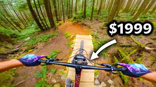
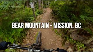
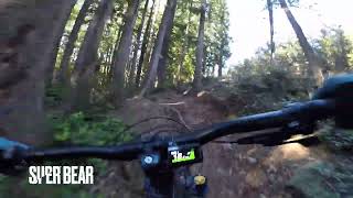
SuperBear is the same line as the old Bear DH Downhill course. Was machined in 2015, but with time has morphed back into a lot of its old self. Top-half is full-on black diamond downhill. Lower half is more flowy with some rollers/jumps but still some consequences.

Please be advised that this trail is Downhill riding only!!

Some old reports and books suggest uphill climbing which is no longer advised. There is a climb trail [L=https://www.trailforks.com/trails/big-trouble-little-chainring/ Big Trouble in Little Chainring/BTLC [/L] which is climbing only from the Mill Pond and will take you to the top of this trail via a logging road.

Access Info

Ascend up Big Trouble Little Chainring, ride across the road, and then descend on Super Bear.

Trail Supporters

  • Gareth

    since 2020
    Builder
  • past supporters

Local Trail Association
Traditionally Indigenous Territory

Recent Activity on Trail

Past Week
  • 9 rides
  • 6 miles average
6 Months
  • 194 rides
  • 7 miles avg distance
All
  • 1,963 rides
  • Last: Jun 28, 2026
c1c2c3c4
January
February
March
April
May
June
July
August
September
October
November
December
update trails status or condition

Super Bear Trail Reports

statusdatedescription
Jun 22, 2026 @ 3:34pm (America/Vancouver)
Jun 22, 2026
Jun 9, 2026 @ 4:08pm (America/Vancouver)
Jun 9, 2026
Thank you to whoever chopped all the foliage! I haven't had a lot of time to dig lately and that saved me a ton of work. Did a quick rake and...
May 20, 2026 @ 11:41am (America/Vancouver)
May 20, 2026
May 9, 2026 @ 4:10pm (America/Vancouver)
May 9, 2026
Apr 25, 2026 @ 4:35pm (America/Vancouver)
Apr 25, 2026
Two stumps gone one left. hopefully have this reroute and drainage work done soon.
more »
Status:
on Jun 22, 2026
Dry
Avg: 4.4 (72 votes)
Your vote: 0

view (8,180)
close
3D
Trail Conditions
  • Unknown
  • Snow Groomed
  • Snow Packed
  • Snow Covered
  • Snow Cover Partial
  • Freeze/thaw Cycle
  • Icy
  • Prevalent Mud
  • Wet
  • Variable
  • Ideal
  • Dry
  • Very Dry
Trail Flow (Ridden Direction)
Trailforks scans users ridelogs to determine the most popular direction each trail is ridden. A good flowing trail network will have most trails flowing in a single direction according to their intension.
The colour categories are based on what percentage of riders are riding a trail in its intended direction.
  • > 96%
  • > 90%
  • > 80%
  • > 70%
  • > 50%
  • < 50%
  • bi-directional trail
  • no data
Trail Last Ridden
Trailforks scans ridelogs to determine the last time a trail was ridden.
  • < 2 days
  • < 1 week
  • < 2 weeks
  • < 1 month
  • < 6 months
  • > 6 months
Trail Ridden Direction
The intended direction a trail should be ridden.
  • Downhill Only
  • Downhill Primary
  • Both Directions
  • Uphill Primary
  • Uphill Only
  • One Direction
Contribute Details
Colors indicate trail is missing specified detail.
  • Description
  • Photos
  • Description & Photos
  • Videos
Trail Popularity ?
Trailforks scans ridelogs to determine which trails are ridden the most in the last 9 months. Trails are compared with nearby trails in the same city region with a possible 25 colour shades. Think of this as a heatmap, more rides = more kinetic energy = warmer colors.
  • most popular
  • popular
  • less popular
  • not popular
ATV/ORV/OHV Filter
Max Vehicle Width
inches
US Cell Coverage
Legend
cell carrier legend

Radar Time
Activity Recordings
Trailforks uses anonymized public activity data. ?
Activity Recordings
Trailforks uses anonymized public activity data. ?
Personal Heatmap
Activity Types
all / none
Options
2
Date range month
Winter Trails
Warning A routing network for winter maps does not exist. Selecting trails using the winter trails layer has been disabled.
Missing Trails
Most Popular
Least Popular
Trails are colored based on popularity. The more popular a trail is, the more red. Less popular trails trend towards green.
Jump Magnitude Heatmap
Heatmap of where riders jump on trails. Zoom in to see individual jumps, click circles to view jump details.
BC Backroad Status

Service Road Atlas is a free to use, community-driven service for viewing and creating reports on the numerous back-country service roads around B.C. and Alberta.

map legend
Slope Aspect
Direction the slope faces
Flat N NE E SE S SW W NW
Trails Deemphasized
Trails are shown in grey.
disable
Only show trails with no bike usage.
Enable
Suggested Layers
Based on selected activity type

    Save the current map location and zoom level as your default home location whenever this page is loaded.

    Save
        Directions to super-bear trailhead (49.195560, -122.311410)

        Photos

        540 more »
        543 |
        Jun 12, 2017 @ 10:53pm
        Jun 12, 2017
        435 |
        Apr 1, 2014 @ 11:42am
        Apr 1, 2014
        66 |
        Jul 21, 2024 @ 12:07pm
        Jul 21, 2024
        56 |
        Jul 21, 2024 @ 12:07pm
        Jul 21, 2024

        Videos

        28 more »
        youtuber My New BUDGET Enduro Bike hasn't held me back yet!
        5:14 | 290 | Sep 14, 2024 , Mission
        Mountain bike trail riding | took on a ...
        8:27 | 90 | Sep 22, 2025 , Mission
        Super Bear - Bear Mountain - Mission, BC
        4:40 | 187 | Jan 30, 2025 , Mission
        MTB Mixtape EP1  No Chainz (Chainless E-biking)
        0:55 | 131 | Jul 21, 2024 , Mission

        Trail Lists

        Routes with this trail

        5.0 6 miles 1,593 ft 8 Loop
        testing out route building
        4.0 15 miles 3,260 ft 28 Loop
        Two Loops: one on Bear and one on Red. I rode Bear first, but you could do Red first as it is a little...
        9 miles 2,216 ft 13
        Fraser Valley Bear Classic Fraser Valley Relive Your Ride For other ride suggestions for this and other...

        Trail Events

        Trail Products

        7 Reviews & Comments


        We hope you've been enjoying Trailforks!

        Create a FREE account to view trail comments and much more.

        Nearby Trails

        • By BCpovTF Pro & contributors
        • #332 - 19,603 views

        Frequently Asked Questions About Super Bear

        Where is Super Bear located?
        Super Bear is located in Bear Mountain, Mission, British Columbia, Canada. It is part of the Bear Mountain trail network. The trailhead is located at coordinates 49.19556, -122.31141.
        How hard is Super Bear?
        Super Bear is rated as Blue difficulty. The physical rating is Moderate. The average grade is 11.7%.
        What is the elevation gain for Super Bear?
        The trail has 716 ft of elevation descent. The elevation ranges from 758 ft to 1,474 ft.
        How long is Super Bear?
        Super Bear is 1.2 miles long. The trail type is singletrack.

        Hit the Trail

        Open in App

        Get this trail on your phone instantly.
        open trail in app

        Download Trail

        Save to wishlist, Garmin & download.
        save the trail

        Find Related Routes

        Find routes and users activities that include this trail.
        find routes for this trail

        You must enter a description before submitting.