more stats
1,457 ft
Distance
40 ft
Climb
-55 ft
Descent
00:03:18
Avg time
-16 ft
Altitude change
767 ft
Altitude min
823 ft
Altitude max
784 ft
Altitude start
768 ft
Altitude end
-1.1%
Grade
-19.6%
Grade max
16.7%
Grade min
427 ft
Distance climb
886 ft
Distance down
39 ft
Distance flat
00:03:18
Avg time

Webs Details

  • Activities
    • Mountain Bike
    • E-Bike
    • Hike
    • Trail Running
    • Snowshoe
  • Riding Area
    Kingdom Trails
    East Burke, Vermont
  • Difficulty Rating
  • Local Popularity
    65 in Mountain Biking [+]
    • 60 in E-Biking
    • 75 in Trail Running
    • 80 in Hiking
    • 5 in Snowshoeing
  • Global Ranking
    #5984 in Mountain Biking [+]
    • #80184 in E-Biking
    • #82010 in Trail Running
    • #36814 in Hiking
    • #1724 in Snowshoeing
  • Hiking SAC Scale
    T1 Hiking
  • Trail Type
    Singletrack
  • Snow Grooming
    Groomed Smooth
  • Bike Type
    XC
  • Direction
    Both Directions
    Popular Direction Shown
  • Climb Difficulty
    Green
  • Physical Rating
    Moderate
  • Trail Visibility
    Always easy to follow
  • eBike Allowed
  • Land Owner
    Kingdom Trail Association

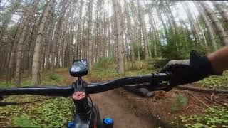
Webs is a short, fun, modestly technical trail with no significant obstacles or technical features. The trail surface is mostly smooth and hardpacked, albeit with some rooty sections. The trail has no significant elevation changes and is suitable for confident novices and above.

Access Info

Webs is accessed of River Run at both ends.

Disclaimer

Please respect the trail closure signs. No Fat Bikes to go beyond the point where signs are posted.

Local Trail Association
Traditionally Indigenous Territory

Recent Activity on Trail

Past Week
  • 7 rides
  • 11 miles average
6 Months
  • 36 rides
  • 15 miles avg distance
All
  • 1,877 rides
  • Last: Jun 6, 2026
c1c2c3c4
January
February
March
April
May
June
July
August
September
October
November
December
update trails status or condition

Webs Trail Reports

statusdatedescription
Apr 24, 2026 @ 2:52pm (America/New_York)
Apr 24, 2026
reporter Southwest section of Darling Hill trails are open!
Apr 18, 2026 @ 11:31am (America/New_York)
Apr 18, 2026
reporter The Wildflower Backyard trails are open for the 2026 season! The rest of the network still needs time to dry out, but we will continue to open...
Oct 31, 2025 @ 9:47pm (America/New_York)
Oct 31, 2025
reporter Winter trails will open after Vermont's deer hunting season concludes AND once the ground is frozen. https://www.kingdomtrails.org/Trail-Conditions
Oct 11, 2025 @ 9:43pm (America/New_York)
Oct 11, 2025
Sep 7, 2025 @ 9:02am
Sep 7, 2025
Tree down
more »
Status:
on Apr 24, 2026
Variable
Avg: 4.14 (15 votes)
Your vote: 0

view (8,080)
close
3D
Trail Conditions
  • Unknown
  • Snow Groomed
  • Snow Packed
  • Snow Covered
  • Snow Cover Partial
  • Freeze/thaw Cycle
  • Icy
  • Prevalent Mud
  • Wet
  • Variable
  • Ideal
  • Dry
  • Very Dry
Trail Flow (Ridden Direction)
Trailforks scans users ridelogs to determine the most popular direction each trail is ridden. A good flowing trail network will have most trails flowing in a single direction according to their intension.
The colour categories are based on what percentage of riders are riding a trail in its intended direction.
  • > 96%
  • > 90%
  • > 80%
  • > 70%
  • > 50%
  • < 50%
  • bi-directional trail
  • no data
Trail Last Ridden
Trailforks scans ridelogs to determine the last time a trail was ridden.
  • < 2 days
  • < 1 week
  • < 2 weeks
  • < 1 month
  • < 6 months
  • > 6 months
Trail Ridden Direction
The intended direction a trail should be ridden.
  • Downhill Only
  • Downhill Primary
  • Both Directions
  • Uphill Primary
  • Uphill Only
  • One Direction
Contribute Details
Colors indicate trail is missing specified detail.
  • Description
  • Photos
  • Description & Photos
  • Videos
Trail Popularity ?
Trailforks scans ridelogs to determine which trails are ridden the most in the last 9 months. Trails are compared with nearby trails in the same city region with a possible 25 colour shades. Think of this as a heatmap, more rides = more kinetic energy = warmer colors.
  • most popular
  • popular
  • less popular
  • not popular
ATV/ORV/OHV Filter
Max Vehicle Width
inches
US Cell Coverage
Legend
cell carrier legend

Radar Time
Activity Recordings
Trailforks uses anonymized public activity data. ?
Activity Recordings
Trailforks uses anonymized public activity data. ?
Personal Heatmap
Activity Types
all / none
Options
2
Date range month
Winter Trails
Warning A routing network for winter maps does not exist. Selecting trails using the winter trails layer has been disabled.
Missing Trails
Most Popular
Least Popular
Trails are colored based on popularity. The more popular a trail is, the more red. Less popular trails trend towards green.
Jump Magnitude Heatmap
Heatmap of where riders jump on trails. Zoom in to see individual jumps, click circles to view jump details.
BC Backroad Status

Service Road Atlas is a free to use, community-driven service for viewing and creating reports on the numerous back-country service roads around B.C. and Alberta.

map legend
Slope Aspect
Direction the slope faces
Flat N NE E SE S SW W NW
Trails Deemphasized
Trails are shown in grey.
disable
Only show trails with no bike usage.
Enable
Suggested Layers
Based on selected activity type

    Save the current map location and zoom level as your default home location whenever this page is loaded.

    Save
        Directions to webs trailhead (44.579760, -71.981250)

        Photos

        6 more »
        366 |
        Apr 13, 2016 @ 8:53am
        Apr 13, 2016
        273 |
        Jun 18, 2013 @ 4:53pm
        Jun 18, 2013
        73 |
        Jun 19, 2022 @ 6:16pm
        Jun 19, 2022
        59 |
        Oct 31, 2021 @ 5:13am
        Oct 31, 2021

        Videos

        2 more »
        River Run to Webs Trail - MTB at Kingdom...
        7:38 | 267 | Sep 14, 2022 , East Burke
        Kingdom Trails - Webs - August 2019 (4K)
        2:37 | 334 | Aug 21, 2019 , East Burke

        Trail Lists

        Routes with this trail

        4.0 5 miles 587 ft 6 Loop
        Plunging NewT-ly: Less Challenging; 5.0 miles; 586 feet total elevation gain; allow approx. 45-60 mins. A...
        44 miles 5,483 ft 51 Loop
        For those long summer days.
        52 miles 6,995 ft 40 Loop
        49 mile route through KT, have fun.

        2 Reviews & Comments


        We hope you've been enjoying Trailforks!

        Create a FREE account to view trail comments and much more.

        Frequently Asked Questions About Webs

        Where is Webs located?
        Webs is located in Kingdom Trails, East Burke, Vermont, United States. It is part of the Kingdom Trails trail network. The trailhead is located at coordinates 44.57976, -71.98125.
        How hard is Webs?
        Webs is rated as Blue difficulty. The physical rating is Moderate. The average grade is 1.1%. The climb difficulty is rated Green.
        What is the elevation gain for Webs?
        Webs has 12 m of elevation gain. The trail has 17 m of elevation descent. The elevation ranges from 234 m to 251 m.
        Is Webs a point to point trail?
        Webs is not a point to point trail. The direction is Both Directions. The trail type is singletrack.

        Hit the Trail

        Open in App

        Get this trail on your phone instantly.
        open trail in app

        Download Trail

        Save to wishlist, Garmin & download.
        save the trail

        Find Related Routes

        Find routes and users activities that include this trail.
        find routes for this trail

        You must enter a description before submitting.