more stats
988 ft
Distance
-86 ft
Descent
00:01:01
Avg time
-86 ft
Altitude change
1,312 ft
Altitude min
1,399 ft
Altitude max
1,399 ft
Altitude start
1,312 ft
Altitude end
-8.7%
Grade
-23.2%
Grade max
-2.9%
Grade min
971 ft
Distance down
16 ft
Distance flat
00:01:01
Avg time

Yeah Nah Details

  • Activities
    • Mountain Bike
  • Riding Area
    Arapuke Forest
    Palmerston North
  • Difficulty Rating
  • Local Popularity
    25 in Mountain Biking
  • Global Ranking
    #126518 in Mountain Biking
  • Trail Type
    Singletrack
  • Direction
    Downhill Only
    Popular Direction Shown
  • eBike Allowed
    Yes up to Class 1
  • Land Owner
    Palmerston North City Council

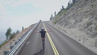
Thin single track following the Eastern Block Road down to join up to Check Point Charlie. Few small bits to get some air and a few logs to dodge along the way.

Access Info

Climb the Eastern Block Road. After passing the right hand turn off to Arapuke Road go a short distance (~20m) down to the start.

Bike Park

Local Trail Association
  • trail association logo
  • Please consider joining or donating to the local trail association to support
    trail development & maintenance.

Recent Activity on Trail

Past Week
  • 0 rides
  •  
6 Months
  • 0 rides
  •  
All
  • 21 rides
  • Last: Feb 21, 2026
c1c2c3c4
January
February
March
April
May
June
July
August
September
October
November
December
update trails status or condition

Yeah Nah Trail Reports

Status:
on Mar 1, 2023
Ideal
Avg: 3.74 (2 votes)
Your vote: 0

view (594)
close
3D
Trail Conditions
  • Unknown
  • Snow Groomed
  • Snow Packed
  • Snow Covered
  • Snow Cover Partial
  • Freeze/thaw Cycle
  • Icy
  • Prevalent Mud
  • Wet
  • Variable
  • Ideal
  • Dry
  • Very Dry
Trail Flow (Ridden Direction)
Trailforks scans users ridelogs to determine the most popular direction each trail is ridden. A good flowing trail network will have most trails flowing in a single direction according to their intension.
The colour categories are based on what percentage of riders are riding a trail in its intended direction.
  • > 96%
  • > 90%
  • > 80%
  • > 70%
  • > 50%
  • < 50%
  • bi-directional trail
  • no data
Trail Last Ridden
Trailforks scans ridelogs to determine the last time a trail was ridden.
  • < 2 days
  • < 1 week
  • < 2 weeks
  • < 1 month
  • < 6 months
  • > 6 months
Trail Ridden Direction
The intended direction a trail should be ridden.
  • Downhill Only
  • Downhill Primary
  • Both Directions
  • Uphill Primary
  • Uphill Only
  • One Direction
Contribute Details
Colors indicate trail is missing specified detail.
  • Description
  • Photos
  • Description & Photos
  • Videos
Trail Popularity ?
Trailforks scans ridelogs to determine which trails are ridden the most in the last 9 months. Trails are compared with nearby trails in the same city region with a possible 25 colour shades. Think of this as a heatmap, more rides = more kinetic energy = warmer colors.
  • most popular
  • popular
  • less popular
  • not popular
ATV/ORV/OHV Filter
Max Vehicle Width
inches
US Cell Coverage
Legend
cell carrier legend

Radar Time
Activity Recordings
Trailforks uses anonymized public activity data. ?
Activity Recordings
Trailforks uses anonymized public activity data. ?
Personal Heatmap
Activity Types
all / none
Options
2
Date range month
Winter Trails
Warning A routing network for winter maps does not exist. Selecting trails using the winter trails layer has been disabled.
Missing Trails
Most Popular
Least Popular
Trails are colored based on popularity. The more popular a trail is, the more red. Less popular trails trend towards green.
Jump Magnitude Heatmap
Heatmap of where riders jump on trails. Zoom in to see individual jumps, click circles to view jump details.
BC Backroad Status

Service Road Atlas is a free to use, community-driven service for viewing and creating reports on the numerous back-country service roads around B.C. and Alberta.

map legend
Slope Aspect
Direction the slope faces
Flat N NE E SE S SW W NW
Trails Deemphasized
Trails are shown in grey.
disable
Only show trails with no bike usage.
Enable
Suggested Layers
Based on selected activity type

    Save the current map location and zoom level as your default home location whenever this page is loaded.

    Save
        Directions to yeah-nah trailhead (-40.480680, 175.611810)

        Photos

        No photos have been added for Yeah Nah yet, add a photo.

        Videos

        1 more »
        Ray Syron | Party Ambassador
        2:44 | 6109 | Sep 13, 2017 , Palmerston North

        Routes with this trail

        12 miles 2,310 ft 197 Loop
        All the trails in the park less the grade 5 trails and jump track. From Kahuterawa Rd car park head up the...
        1,916 ft 2 Point to Point
        This stage starts at the top of the park and is run over (G4) and finishes in the vicinity of the...
        5 miles 702 ft 18 Loop Race
        We have nicked named this event "superflow". We head to Palmerston North's Arapuke Forest park to ride...

        Reviews / Comments

        No reviews yet, be the first to write a review or ask a question.
        Use trail reports to comment on trail conditions.


        We hope you've been enjoying Trailforks!

        Create a FREE account to view trail comments and much more.

        • By pickledmarmaladetoast1888 & contributors
        • #67223 - 1,930 views

        Frequently Asked Questions About Yeah Nah

        Where is Yeah Nah located?
        Yeah Nah is located in Arapuke Forest, Palmerston North, New Zealand. It is part of the Arapuke Forest trail network. The trailhead is located at coordinates -40.48068, 175.61181.
        How hard is Yeah Nah?
        Yeah Nah is rated as Blue difficulty. The average grade is 8.7%.
        What is the elevation gain for Yeah Nah?
        The trail has 86 ft of elevation descent. The elevation ranges from 1,312 ft to 1,399 ft.
        Is Yeah Nah a point to point trail?
        Yes, Yeah Nah is a point to point trail. The direction is Downhill Only. The trail type is singletrack.

        Hit the Trail

        Open in App

        Get this trail on your phone instantly.
        open trail in app

        Download Trail

        Save to wishlist, Garmin & download.
        save the trail

        Find Related Routes

        Find routes and users activities that include this trail.
        find routes for this trail

        You must enter a description before submitting.