close
-
Layers w
- Weather Layers
- Pro
- Pro
- Pro
- Pro
- Pro
- Pro
- More Layers
- Pro
- Pro
- Pro
- Pro
-
Upgrade to

3D
Trail Conditions
- Unknown
- Snow Groomed
- Snow Packed
- Snow Covered
- Snow Cover Partial
- Freeze/thaw Cycle
- Icy
- Prevalent Mud
- Wet
- Variable
- Ideal
- Dry
- Very Dry
Trail Flow (Ridden Direction)
Trailforks scans users activity logs to determine the most popular direction each trail is ridden. A good flowing trail network will have most trails flowing in a single direction according to their intension.
The colour categories are based on what percentage of users are riding a trail in its intended direction.
The colour categories are based on what percentage of users are riding a trail in its intended direction.
- > 96%
- > 90%
- > 80%
- > 70%
- > 50%
- < 50%
- bi-directional trail
- no data
Trail Last Ridden
Trailforks scans activity logs to determine the last time a trail was ridden.
- < 2 days
- < 1 week
- < 2 weeks
- < 1 month
- < 6 months
- > 6 months
Trail Ridden Direction
The intended direction a trail should be ridden.
- Downhill Only
- Downhill Primary
- Both Directions
- Uphill Primary
- Uphill Only
- One Direction
Contribute Details
Colors indicate trail is missing specified detail.
- Description
- Photos
- Description & Photos
- Videos
Trail Popularity ?
Trailforks scans activity logs to determine which trails are ridden the most in the last 9 months.
Trails are compared with nearby trails in the same city region with a possible 25 colour shades.
Think of this as a heatmap, more activities = more kinetic energy = warmer colors.
- most popular
- popular
- less popular
- not popular
ATV/ORV/OHV Filter
Max Vehicle Width
inches
US Cell Coverage
Legend

Radar Time
Activity Recordings
Trailforks uses anonymized public activity data.
?
Activity Recordings
Trailforks uses anonymized public activity data.
?
Personal Heatmap
▶
Activity Types
all
/
none
▶
Options
2
Date range
month
–
Winter Trails
Warning
A routing network for winter maps does not exist. Selecting trails using the winter trails layer has been disabled.
Missing Trails
Most Popular
Least Popular
Trails are colored based on popularity. The more popular a trail is, the more red. Less popular trails trend towards green.
Jump Magnitude Heatmap
Heatmap of where users jump on trails. Zoom in to see individual jumps, click circles to view jump details.
BC Backroad Status
![map legend]()
Service Road Atlas is a free to use, community-driven service for viewing and creating reports on the numerous back-country service roads around B.C. and Alberta.

Slope Aspect
Direction the slope faces
Trails Deemphasized
Trails are shown in grey.
Only show trails with no bike usage.
Suggested Layers
Based on selected activity type
Save the current map location and zoom level as your default home location whenever this page is loaded.
SaveActivities Click to view
- Mountain Bike
133 trails
- E-Bike
26 trails
- Gravel Bike
73 trails
- Adaptive Bike
14 trails
- Winter Fat Bike
14 trails
- Horse
33 trails
- Hike
241 trails
- Trail Running
238 trails
- Dirtbike/Moto
7 trails
- Observed Trials
7 trails
- ATV/ORV/OHV
11 trails
- Snowmobile
3 trails
- Snowshoe
18 trails
- Backcountry Ski
16 trails
- Nordic Ski
18 trails
Region Details
- 59
- 3
- 14
- 38
- 18
- 1
Region Status
Caution as of 1 dayStats
- Avg Trail Rating
- Trails (view details)
- 242
- Trails Mountain Bike
- 133
- Trails E-Bike
- 26
- Trails Gravel Bike
- 73
- Trails Adaptive Bike
- 14
- Trails Winter Fat Bike
- 14
- Trails Horse
- 33
- Trails Hike
- 241
- Trails Trail Running
- 238
- Trails Dirtbike/Moto
- 7
- Trails Observed Trials
- 7
- Trails ATV/ORV/OHV
- 11
- Trails Snowmobile
- 3
- Trails Snowshoe
- 18
- Trails Backcountry Ski
- 16
- Trails Nordic Ski
- 18
- Total Distance
- 491 miles
- Total Descent
- 102,089 ft
- Total Vertical
- 5,160 ft
- Highest Trailhead
- 6,206 ft
- Reports
- 3,933
- Photos
- 1,943
- Completed Counter
- 111,879
Articles
The 12 Most Stunning Trails in the U.S.
May 29, 2025 from outsideonline.com
In celebration of National Trails Day, discover some of the best hikes in the U.S.—from slot canyons to grasslands, waterfalls, and secluded...
North Carolina's 5 Most Popular Trail Networks According to Trailforks Data
Oct 20, 2021 from pinkbike.com
North Carolina is covered by trails of all varieties, and offers up opportunities for riders of all stripes.
Local Flavours: The Complete Guide to Riding in Brevard, NC
Oct 21, 2019 from pinkbike.com
Brice is back with a report from the Blue Ridge Mountains.
Sub Regions
-
Bracken Preserve
- 1
- 6
- 1
-
Gorges State Park
- 1
- 1
-
Jocassee Gorges Wildlife Management Area
- 1
-
Pisgah / Brevard
- 3
- 10
- 1
-
Pisgah Ranger District
- 7
- 18
- 15
- 1
-
REEB Ranch
- 1
- 2
-
Shining Rock Wilderness
- 1
- 1
Popular Brevard Mountain Biking Trails
• 100 ★ 4.8 • 1 mile • 0 ft • 5,349 •
Black Mountain Trail is split into 4 sections (Upper/Upper, Upper, Middle and Lower) The lower section of #127 is probably the most popular section of Black Mountain. From the intersection with Thrift Cove and Middle Black riders will...
• 100 ★ 4.8 • 2 miles • 126 ft • 3,786 •
In 2021 the section known as Middle Black was rerouted due to the continuous erosion and trail widening that was happening on its former line. Pisgah Area SORBA and Singletrack Trails have worked together to create a sustainable trail...
• 95 ★ 4.4 • 3 miles • 43 ft • 3,153 •
The newly reworked (Aug 2019) trail begins and ends at the same location as before, but has completely changed in character since Nature Trails, LLC rebuilt the trail. The new trail is wider, smoother, and less eroded than the previous...
• 85 ★ 4.6 • 3 miles • 94 ft • 2,933 •
Now open year round to bikes thanks to trail advocacy. Excellent ridgetop views of Looking Glass Rock, Cedar Rock, and the Davidson River valley. Technical sections near the intersection with Tr. with nearly sheer drop-offs on the...
• 95 ★ 4.4 • 3 miles • 776 ft • 2,703 •
Double-track that narrows to a wide single in places, often ridden up (climb north-bound) as part of a short loop with Lower Black
• 100 ★ 4.2 • 1 mile • 312 ft • 2,675 •
Highly rated popular green difficulty singletrack. This multi-use trail can be used downhill primary. On average it takes 10 minutes to complete this trail.
• 85 ★ 3.0 • 4,209 ft • 455 ft • 2,400 •
Commonly used to climb from Road to the intersection that leads to Trail, Upper and . Mostly ridable, some riders may find a few very short sections to be hike-a-bike.
• 90 ★ 4.2 • 2 miles • 260 ft • 2,327 •
Black Mountain Trail is split into 4 sections (Upper/Upper, Upper, Middle and Lower) The section of trail referred to as 'Upper Upper Black' was rehabilitated in July 2019 by Nature Trails, LLC. The primary area of rehabilitation is...
Brevard Mountain Bike Routes
★ 3.5 • 19 miles • 3,870 ft • 9 •
Another first for the 3rd Coast Enduro Series as the series stops in Brevard North Carolina for its 6th...
19 miles • 2,000 ft • 5 •
This route climbs 2200 feet, and travels 21 miles starting from Ecusta Brewing on the Brevard Greenway...
25 miles • 1,902 ft • 2 •
This Gravel Ride gains around 2,000 feet of elevation over 25 miles on mostly gravel roads with a few...
6 miles • 637 ft • 2 •
This 6 mile loop starts at Ecusta Brewing on the Brevard Greenway and heads into the Pisgah National...
WNC Bike Fest Grassy/Sycamore Loop Featured
7 miles • 637 ft • 4 •
This short 7.5 mile route, with only 650' of climbing leaves from Ecusta Brewing on the Brevard Greenway...
8 miles • 795 ft • 7 •
This 8 mile route, with 800' of elevation gain starts at Ecusta Brewing and takes the Brevard Greenway...
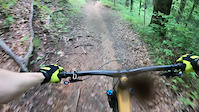
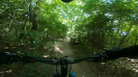
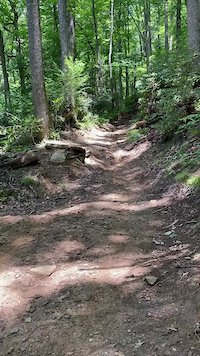
Photos of Brevard Mountain Bike
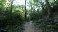
Videos of Brevard Mountain Bike
trail: Jones Gap NRT
0:15 |
|
Sep 1, 2024
trail: Avery Creek Trail
0:09 |
121 |
May 17, 2024

trail: Daniel Ridge
3:24 |
|
Nov 4, 2023

trail: Daniel Ridge
3:24 |
|
Oct 29, 2023
trail: Bennett Gap Trail
0:49 |
76 |
Nov 2, 2022
trail: Avery Creek Trail
0:19 |
121 |
Jul 18, 2022
trail: Sycamore Cove Trail
0:54 |
87 |
Feb 20, 2022
trail: Black Mountain Trail (Lower)
5:02 |
65 |
Feb 16, 2022
Current Trail Warnings
| status | trail | date | condition | user | info |
|---|---|---|---|---|---|
| Yellow Gap Road | Jul 26, 2026 @ 7:48pm (America/New_York) 1 day | Variable | DavidSA | 1206 full closure on weekdays until... | |
| Galactic Scheisse | Jun 28, 2026 @ 12:40pm (America/Vancouver) Jun 28, 2026 | Ideal | ohmagard | Tree down - tricky to climb over and lift... |
Recent Trail Reports
Activity Feed
| username | action | type | title | date |
|---|---|---|---|---|
| JarrettBowen9 | wishlist | route | activity #100152760 | Jul 27, 2026 @ 1:19pm 4 hours |
| jenhefner | wishlist | route | activity #100118198 | Jul 27, 2026 @ 2:56am 14 hours |
| DavidSA | add | report | activity #100097835 | Jul 26, 2026 @ 4:49pm 1 day |
| RuY2kK | wishlist | trail | activity #100091068 | Jul 26, 2026 @ 3:18pm 1 day |
| shriddledeedum | add | report | activity #100007761 | Jul 25, 2026 @ 2:49pm 2 days |
Recent Comments
| username | type | title | comment | date |
|---|---|---|---|---|
| trail | Still washed out! | Jul 22, 2026 @ 7:35pm Jul 22, 2026 | ||
| report | , c. ,,,,,,,,,, vv. VV vvv VB. ... | Jul 13, 2026 @ 1:20pm Jul 13, 2026 | ||
| trail | Rode this down from clawhammer. Not worth it... | Jul 2, 2026 @ 2:16pm Jul 2, 2026 | ||
| trail | Advanced trail. Definitely popular as has... | Jun 21, 2026 @ 5:09pm Jun 21, 2026 | ||
| trail | Its an old trail, rooty, puddles lingering.... | Jun 21, 2026 @ 5:05pm Jun 21, 2026 |
Local Badges
-

Full Black - Full Enchilada 2.0347 awarded -

The Farlow Badge249 awarded -

10 Black Trails725 awarded -
10 Black Trails864 awarded -

Completionist - Life Time0 awarded -

Top 10 Trails31 awarded
Activity Type Stats
| activitytype | trails | distance | descent | descent distance | total vertical | rating | global rank | state rank | photos | reports | routes | activity logs |
|---|---|---|---|---|---|---|---|---|---|---|---|---|
| Mountain Bike | 133 | 255 miles | 40,535 ft | 114 miles | 4,767 ft | #212 | #79 | 1,788 | 3,892 | 178 | 86,467 | |
| E-Bike | 26 | 57 miles | 7,927 ft | 21 miles | 3,366 ft | #2,484 | #1,008 | 2,652 | 1 | 1,648 | ||
| Gravel Bike | 73 | 153 miles | 17,854 ft | 59 miles | 5,052 ft | #54 | #698 | 3 | 662 | 5 | 353 | |
| Adaptive Bike | 14 | 12 miles | 1,421 ft | 6 miles | 2,172 ft | #328 | #1,553 | 158 | 1 | 6 | ||
| Winter Fat Bike | 14 | 10 miles | 1,496 ft | 5 miles | 1,683 ft | #245 | #948 | 10 | ||||
| Horse | 33 | 98 miles | 11,030 ft | 32 miles | 4,692 ft | #446 | #488 | 867 | 7 | |||
| Hike | 241 | 490 miles | 102,087 ft | 228 miles | 5,161 ft | #144 | #82 | 149 | 3,903 | 24 | 13,288 | |
| Trail Running | 238 | 485 miles | 101,122 ft | 225 miles | 5,161 ft | #165 | #73 | 3 | 3,902 | 25 | 4,132 | |
| Dirtbike/Moto | 7 | 34 miles | 4,334 ft | 10 miles | 3,337 ft | #608 | #205 | 457 | 7 | |||
| Observed Trials | 7 | 34 miles | 4,334 ft | 10 miles | 3,337 ft | #35 | #14 | 18 | 14 | |||
| ATV/ORV/OHV | 11 | 43 miles | 5,778 ft | 16 miles | 4,741 ft | #383 | #116 | 458 | 11 | |||
| Snowmobile | 3 | 20 miles | 522 ft | 2 miles | 2,923 ft | #79 | #48 | 8 | 1 | |||
| Snowshoe | 18 | 41 miles | 3,986 ft | 11 miles | 2,349 ft | #406 | #125 | 126 | 5 | |||
| Backcountry Ski | 16 | 25 miles | 3,976 ft | 10 miles | 1,781 ft | #317 | #55 | 110 | 12 | |||
| Nordic Ski | 18 | 41 miles | 3,986 ft | 11 miles | 2,349 ft | #453 | #132 | 126 | 7 |
Frequently Asked Questions About Brevard
▼
What are the best places to ride in Brevard?
Brevard has 8 areas to explore for mountain biking. The top rated areas are:
▼
What are the highest rated mountain biking trails in Brevard?
The highest rated mountain biking trails in Brevard are:
- Black Mountain Trail (Lower) (4.7/5)
- Black Mountain Trail (Middle) (4.6/5)
- Bennett Gap Trail (4.5/5)
- Pilot Rock (4.4/5)
- Buckwheat Knob Trail (4.4/5)
▼
What is the best time of the year to ride in Brevard?
Based on activity log data, the most popular months to ride in Brevard are:
- April (647 activities)
- May (557 activities)
- October (554 activities)
▼
Where can I park to ride in Brevard?
There are 45 parking locations listed in Brevard. The most popular parking spots are:
- Horse Stables - Parking
- Thrift CoveTrailhead Parking
- Art Loeb Trailhead Parking
- Cove Creek Camp Parking
- Daniel Ridge Parking
Activities
- Brevard Mountain Biking Trails
- Brevard E-Biking Trails
- Brevard Gravel Biking Trails
- Brevard Adaptive Biking Trails
- Brevard Winter Fat Biking Trails
- Brevard Horseback Trails
- Brevard Hiking Trails
- Brevard Trail Running Trails
- Brevard Dirtbiking Trails
- Brevard Observed Trials Trails
- Brevard ATVing/Offroading Trails
- Brevard Snowshoeing Trails
- Brevard Backcountry Skiing Trails
- Brevard Nordic Skiing Trails
Trails
Points of Interest
- Bear Gap Disbursed Camping
- Bearcamp Disbursed Camping
- Windy Falls Sight
- Toxaway Shoals Bridge
- Toxaway Creek Campsites Camping
- Lower Bearwallow Falls Sight
- Toxaway Shoals Sight
- Eel Line Falls Sight
- Buck Fields Disbursed Camping
- State Line Disbursed Camping - North Carolina
- Black Balsam Knob (6,211 ft)
- Tennent Mountain (6,063 ft)
- Sam Knob (6,040 ft)
- By caleb93
 & contributors
 - Admins: apply
- #4413 - 54,980 views
- brevard activity log | embed map of Brevard mountain bike trails | brevard mountain biking points of interest
Downloading of trail gps tracks in kml & gpx formats is enabled for Brevard.
You must login to download files.