close
-
Layers w
- Weather Layers
- Pro
- Pro
- Pro
- Pro
- Pro
- Pro
- More Layers
- Pro
- Pro
- Pro
- Pro
-
Upgrade to

3D
Trail Conditions
- Unknown
- Snow Groomed
- Snow Packed
- Snow Covered
- Snow Cover Partial
- Freeze/thaw Cycle
- Icy
- Prevalent Mud
- Wet
- Variable
- Ideal
- Dry
- Very Dry
Trail Flow (Ridden Direction)
Trailforks scans users activity logs to determine the most popular direction each trail is ridden. A good flowing trail network will have most trails flowing in a single direction according to their intension.
The colour categories are based on what percentage of users are riding a trail in its intended direction.
The colour categories are based on what percentage of users are riding a trail in its intended direction.
- > 96%
- > 90%
- > 80%
- > 70%
- > 50%
- < 50%
- bi-directional trail
- no data
Trail Last Ridden
Trailforks scans activity logs to determine the last time a trail was ridden.
- < 2 days
- < 1 week
- < 2 weeks
- < 1 month
- < 6 months
- > 6 months
Trail Ridden Direction
The intended direction a trail should be ridden.
- Downhill Only
- Downhill Primary
- Both Directions
- Uphill Primary
- Uphill Only
- One Direction
Contribute Details
Colors indicate trail is missing specified detail.
- Description
- Photos
- Description & Photos
- Videos
Trail Popularity ?
Trailforks scans activity logs to determine which trails are ridden the most in the last 9 months.
Trails are compared with nearby trails in the same city region with a possible 25 colour shades.
Think of this as a heatmap, more activities = more kinetic energy = warmer colors.
- most popular
- popular
- less popular
- not popular
ATV/ORV/OHV Filter
Max Vehicle Width
inches
US Cell Coverage
Legend

Radar Time
Activity Recordings
Trailforks uses anonymized public activity data.
?
Activity Recordings
Trailforks uses anonymized public activity data.
?
Personal Heatmap
▶
Activity Types
all
/
none
▶
Options
2
Date range
month
–
Winter Trails
Warning
A routing network for winter maps does not exist. Selecting trails using the winter trails layer has been disabled.
Missing Trails
Most Popular
Least Popular
Trails are colored based on popularity. The more popular a trail is, the more red. Less popular trails trend towards green.
Jump Magnitude Heatmap
Heatmap of where users jump on trails. Zoom in to see individual jumps, click circles to view jump details.
BC Backroad Status
![map legend]()
Service Road Atlas is a free to use, community-driven service for viewing and creating reports on the numerous back-country service roads around B.C. and Alberta.

Slope Aspect
Direction the slope faces
Trails Deemphasized
Trails are shown in grey.
Only show trails with no bike usage.
Suggested Layers
Based on selected activity type
Save the current map location and zoom level as your default home location whenever this page is loaded.
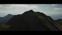
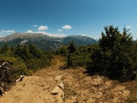
SaveEpirus is a predominantly rugged and mountainous region. It is largely made up of the Pindus Mountains, a series of parallel limestone ridges that are a continuation of the Dinaric Alps.[1][8] The Pindus mountains form the spine of mainland Greece and separate Epirus from Macedonia and Thessaly to the east. The ridges of the Pindus are parallel to the sea and generally so steep that the valleys between them are mostly suitable for pasture rather than large-scale agriculture.[1] Altitude increases as one moves east, away from the coast, reaching a maximum of 2637m at Mount Smolikas, the highest point in Epirus. Other important ranges include Tymfi (2496 at Mount Gamila), Lygkos (2249m), to the west and east of Smolikas respectively, Gramos (2523m) in the northeast, Tzoumerka (2356m) in the southeast, Tomaros (1976m) in the southwest, Mitsikeli near Ioannina (1810m), Mourgana (1806m) and Nemercke/Aeoropos (2485m) on the border between Greece and Albania, and the Ceraunian Mountains (2000m) near Himara in Albania. Most of Epirus lies on the windward side of the Pindus, and the prevailing winds from the Ionian Sea make the region the rainiest in mainland Greece.[1]
Significant lowlands are to be found only near the coast, in the southwest near Arta and Preveza, in the Acheron plain between Paramythia and Fanari, between Igoumenitsa and Sagiada, and also near Saranda. The Zagori area is a scenic upland plateau surrounded by mountain on all sides.
The main river flowing through Epirus is Aoös, which flows in a northwesterly direction from the Pindus mountains in Greece to its mouth north of the Bay of Vlorë in Albania. Other important rivers include the Acheron river, famous for its religious significance in ancient Greece and site of the Necromanteion, the Arachthos river, crossed by the historic Bridge of Arta, the Louros, the Thyamis or Kalamas, and the Voidomatis, a tributary of the Vjosë flowing through the Vikos Gorge. The Vikos Gorge, one of the deepest in the world, forms the centerpiece of the Vikos–Aoös National Park, known for its scenic beauty. The only significant lake in Epirus is Lake Pamvotis, on whose shores lies the city of Ioannina, the region's largest and traditionally most important city.
The climate of Epirus is Mediterranean along the coast and Alpine in the interior. Epirus is heavily forested, mainly by coniferous species. The fauna in Epirus is especially rich and features species such as bears, wolves, foxes, deer and lynxes.
Epirus has historically been a remote and isolated region due to its location between the Pindus mountains and the sea. In antiquity, the Roman Via Egnatia passed through Epirus Nova, which linked Byzantium and Thessalonica to Dyrrachium on the Adriatic Sea. The modern Egnatia highway, which links Ioannina to the Greek province of Macedonia and terminating at Igoumenitsa, is the only highway through the Pindus mountains and has served to greatly reduce the region's isolation. The Aktio-Preveza Undersea Tunnel connects the southernmost tip of Epirus, near Preveza, with Aetolia-Acarnania in western Greece. Ferry services from Igoumenitsa to the Ionian islands and Italy exist. The only airport in Epirus is the Ioannina National Airport, while the Aktion National Airport is located just south of Preveza in Aetolia-Acarnania. There are no railroads in Epirus.
Stats
- Avg Trail Rating
- Trails (view details)
- 50
- Trails Mountain Bike
- 54
- Trails E-Bike
- 35
- Trails Hike
- 48
- Trails Trail Running
- 45
- Trails Downhill Ski
- 19
- Total Distance
- 77 miles
- Total Descent
- 26,338 ft
- Total Vertical
- 6,711 ft
- Highest Trailhead
- 7,092 ft
- Reports
- 177
- Photos
- 172
- Completed Counter
- 615
Popular Trail Networks
view all areas »Sub Regions
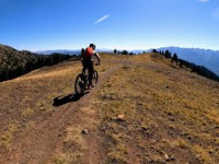
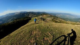
Popular Epirus Mountain Biking Trails
• 100 ★ 5.0 • 1 mile • 15 ft • 63 •
Trail which becomes progressively harder and features several table top jumps, gap jumps, drops and a rock garden. Prefect for riders who want to take their riding to the next level. All features have a ride around.
• 5 ★ 4.0 • 2 miles • 41 ft • 44 •
Fast technical track with berms, off-camber and alpine sections. Featured in the fourth stop of the Enduro Greek Series race of 2022.
• 5 ★ 5.0 • 2 miles • 142 ft • 37 •
Bike Park style single track featuring big berms, jumps leading to single track. Featured in the fourth stop of the Enduro Greek Series race of 2022.
• 5 ★ 4.5 • 2 miles • 88 ft • 36 •
Technical track with rock gardens flow and steep bits. Featured in the fourth stop of the Enduro Greek Series race of 2022.
• 100 ★ 5.0 • 3 miles • 10 ft • 31 •
The trail starts near the top of Mt. Smolikas and ends at the village of Pades
• 50 ★ 0.0 • 2 miles • 234 ft • 14 •
XC single track with great views of the river
• 70 ★ 4.5 • 4,570 ft • 0 ft • 13 •
Local Race Track / part of the greek national open cup 2013-2014-2016
Epirus Mountain Bike Routes
20 miles • 2,693 ft • 3 • Loop •
Mountain biking in Voutsaras, Ioannina, in an absolutely incredible environment. Races are held in May of...
74 miles • 13,900 ft • 0 • Point to Point • Race •
The Ultra distance will cover 118 km and over 3550 m of elevation.Participants must climb to an altitude...
★ 4.0 • 15 miles • 2,960 ft • 6 • Race •
Enduro Greek Series Round #4 2022
Photos of Epirus Mountain Bike
Videos of Epirus Mountain Bike
trail: Pramadol
0:00 |
46 |
Aug 10, 2022

trail: THE Trail
0:08 |
402 |
Oct 23, 2014
trail: U-turn
0:06 |
150 |
Apr 25, 2014

trail: Tschelonas
0:16 |
22 |
Nov 12, 2025 , Ioannina
trail: Dragonlake downhill
24:06 |
327 |
Oct 10, 2022 , Konitsa
trail: EGS Chamois Ride - PS1
8:54 |
270 |
Sep 15, 2022 , Ioannina

trail: Pramadol
4:08 |
475 |
Sep 6, 2022 , Ioannina
trail: Loosetrail
5:21 |
264 |
Aug 1, 2022 , Ioannina
Recent Trail Reports
| status | trail | date | condition | info | user |
|---|---|---|---|---|---|
| Dragonlake downhill Konitsa | Jun 13, 2026 @ 9:31am (Europe/Tirane) Jun 13, 2026 | Ideal | JimmyKane | ||
| Driskos Uphill Ioannina | Mar 29, 2026 @ 11:47am (Europe/Tirane) Mar 29, 2026 | Ideal | JimmyKane | ||
| Supertrail DH Ioannina | Mar 29, 2026 @ 11:47am (Europe/Tirane) Mar 29, 2026 | Ideal | JimmyKane | ||
| Loosetrail Ioannina | Mar 29, 2026 @ 11:47am (Europe/Tirane) Mar 29, 2026 | Ideal | JimmyKane | ||
| Tschelonas Ioannina | Mar 29, 2026 @ 11:47am (Europe/Tirane) Mar 29, 2026 | Ideal | JimmyKane | ||
| Kopsi - Tarifa Frotzos forest | Jan 31, 2026 @ 12:45pm (Europe/Tirane) Jan 31, 2026 | Ideal | JimmyKane | ||
| Frotzos 2 Frotzos forest | Jan 31, 2026 @ 12:45pm (Europe/Tirane) Jan 31, 2026 | Wet | JimmyKane | ||
| Pyramid Frotzos forest | Dec 31, 2025 @ 3:14pm (Europe/Tirane) Dec 31, 2025 | Unknown | JimmyKane | ||
| Connector Frotzos forest | Nov 26, 2025 @ 3:57pm (Europe/Tirane) Nov 26, 2025 | Wet | JimmyKane | ||
| Αγριόχοιρος - Wild Boar Ioannina | Oct 29, 2025 @ 8:26pm (Europe/Athens) Oct 29, 2025 | Unknown | ioanninamountainbikecoalition IMBC |
Activity Feed
| username | action | type | title | date |
|---|---|---|---|---|
| vileda | wishlist | trail | activity #98699850 | Jul 8, 2026 @ 3:02am Jul 8, 2026 |
| DominoJim | wishlist | region | activity #98554617 | Jul 5, 2026 @ 9:07pm Jul 5, 2026 |
| JimmyKane | add | report | activity #96966411 | Jun 14, 2026 @ 7:28am Jun 14, 2026 |
| Theodore-zero1 | wishlist | trail | activity #95099708 and 1 more | May 20, 2026 @ 4:57am May 20, 2026 |
| jibbme | ridden | trail | activity #94698151 | May 14, 2026 @ 10:11am May 14, 2026 |
Recent Comments
| username | type | title | comment | date |
|---|---|---|---|---|
| trail | Το μονοπάτι ξεκινά από το... | Sep 13, 2025 @ 11:57am Sep 13, 2025 | ||
| trail | Το μονοπάτι ξεκινά από... | Sep 13, 2025 @ 11:38am Sep 13, 2025 | ||
| trail | ... | Nov 15, 2023 @ 4:10am Nov 15, 2023 | ||
| report | Αντε να δούμε πότε θα... | Nov 25, 2020 @ 2:55am Nov 25, 2020 |
Local Badges
-

Descent 10k Badge5 awarded -

Climbing 10k Badge5 awarded -

Mountain Biking 100k Badge1 awarded -

Epic Ride Descent 2k17 awarded -

Big Ride 30k128 awarded -

Epic Ride 50k61 awarded
Activity Type Stats
| activitytype | trails | distance | descent | descent distance | total vertical | rating | global rank | state rank | photos | reports | routes | activity logs |
|---|---|---|---|---|---|---|---|---|---|---|---|---|
| Mountain Bike | 54 | 77 miles | 26,339 ft | 39 miles | 6,713 ft | 171 | 177 | 4 | 3,747 | |||
| E-Bike | 35 | 49 miles | 17,641 ft | 25 miles | 6,713 ft | 151 | 66 | |||||
| Hike | 48 | 70 miles | 21,417 ft | 34 miles | 6,713 ft | 1 | 160 | 1 | 641 | |||
| Trail Running | 45 | 66 miles | 21,332 ft | 33 miles | 6,713 ft | 160 | 1 | 168 | ||||
| Downhill Ski | 19 | 20 |
Activities
Trails
- By brenthillier
 NSMBA TRAILFORKS & contributors
 - Admins: haristheodoropoulos, mikesf
- #11371 - 5,357 views
- epirus activity log | embed map of Epirus mountain bike trails | epirus mountain biking points of interest
Downloading of trail gps tracks in kml & gpx formats is enabled for Epirus.
You must login to download files.