close
-
Layers w
- Map Content
- More Layers
- Pro
- Pro
- Pro
- Pro
- Pro
- Pro
- Pro
- Pro
-
Upgrade to

3D
Trail Conditions
- Unknown
- Snow Groomed
- Snow Packed
- Snow Covered
- Snow Cover Partial
- Freeze/thaw Cycle
- Icy
- Prevalent Mud
- Wet
- Variable
- Ideal
- Dry
- Very Dry
Trail Flow (Ridden Direction)
Trailforks scans users ridelogs to determine the most popular direction each trail is ridden. A good flowing trail network will have most trails flowing in a single direction according to their intension.
The colour categories are based on what percentage of riders are riding a trail in its intended direction.
The colour categories are based on what percentage of riders are riding a trail in its intended direction.
- > 96%
- > 90%
- > 80%
- > 70%
- > 50%
- < 50%
- bi-directional trail
- no data
Trail Last Ridden
Trailforks scans ridelogs to determine the last time a trail was ridden.
- < 2 days
- < 1 week
- < 2 weeks
- < 1 month
- < 6 months
- > 6 months
Trail Ridden Direction
The intended direction a trail should be ridden.
- Downhill Only
- Downhill Primary
- Both Directions
- Uphill Primary
- Uphill Only
- One Direction
Contribute Details
Colors indicate trail is missing specified detail.
- Description
- Photos
- Description & Photos
- Videos
Trail Popularity ?
Trailforks scans ridelogs to determine which trails are ridden the most in the last 9 months.
Trails are compared with nearby trails in the same city region with a possible 25 colour shades.
Think of this as a heatmap, more rides = more kinetic energy = warmer colors.
- most popular
- popular
- less popular
- not popular
ATV/ORV/OHV Filter
Max Vehicle Width
inches
US Cell Coverage
Legend

Radar Time
x
Activity Recordings
Trailforks users anonymized public ridelogs from the past 6 months.
- mountain biking recent
- mountain biking (>6 month)
- hiking (1 year)
- moto (1 year)
Activity Recordings
Trailforks users anonymized public skilogs from the past 12 months.
- Downhill Ski
- Backcountry Ski
- Nordic Ski
- Snowmobile
Winter Trails
Warning
A routing network for winter maps does not exist. Selecting trails using the winter trails layer has been disabled.
x
Missing Trails
Most Popular
Least Popular
Trails are colored based on popularity. The more popular a trail is, the more red. Less popular trails trend towards green.
Jump Magnitude Heatmap
Heatmap of where riders jump on trails. Zoom in to see individual jumps, click circles to view jump details.
Trails Deemphasized
Trails are shown in grey.
Only show trails with NO bikes.
Save the current map location and zoom level as your default home location whenever this page is loaded.
Save
No description for Finale Outdoor Region has been added yet!
Login or register to submit one.
 google parking directions
eBikes Allowed:
Yes
Shuttleable: YES
AKA: Finale Outdoor Resort, Finale Ligure, FOR
Land Status: Regional Recreation Area
Land Manager: Finale Outdoor Region
google parking directionsLinks
This region uses the Uk/Euro style trail grading system.
Activities Click to view
- Mountain Bike
212 trails
- E-Bike
189 trails
- Hike
120 trails
- Trail Running
118 trails
Region Details
- 48
- 19
- 91
- 13
- 30
Region Status
Open as of 14 hoursLocal Trail Association
Trail Running Stats
- Global Ranking
- #138
- State Ranking
- #1
- Trails (view details)
- 118
- Trails Mountain Bike
- 212
- Trails E-Bike
- 189
- Trails Hike
- 120
- Trails Trail Running
- 118
- Total Distance
- 130 miles
- Total Descent Distance
- 64 miles
- Total Descent
- 39,364 ft
- Total Vertical
- 4,278 ft
- Reports
- 7,566
- Ridden Counter
- 612
Popular Finale Outdoor Region Trail Running Trails
Photos of Finale Outdoor Region
trail: Ruote di Pietra
128 |
Jan 4, 2023 @ 5:25am
Jan 4, 2023
trail: Ruote di Pietra
233 |
Nov 19, 2021 @ 9:30am
Nov 19, 2021
trail: Briga Destra
545 |
Nov 1, 2021 @ 11:48am
Nov 1, 2021
trail: Madonna della Guardia
716 |
Aug 14, 2021 @ 2:48am
Aug 14, 2021
trail: Kill Bill 2
204 |
Jun 10, 2021 @ 8:44am
Jun 10, 2021
trail: Cacciatore
218 |
Nov 19, 2020 @ 1:12am
Nov 19, 2020
trail: Pino Morto
259 |
Oct 2, 2020 @ 4:55am
Oct 2, 2020
trail: Kill Bill 2
359 |
Mar 29, 2016 @ 1:27pm
Mar 29, 2016Videos of Finale Outdoor Region
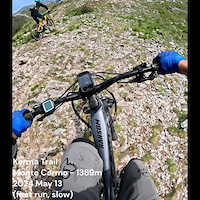
trail: Karma Trail
14 |
May 13, 2024

trail: H Veloce
2 |
May 10, 2024

trail: Campogrande - San Rocco
3 |
May 10, 2024
trail: CNC
2 |
May 1, 2024
trail: Armuin
6 |
May 1, 2024

trail: DH Donne
33 |
Feb 17, 2024

trail: Collegamento Vilmar
7 |
Feb 15, 2024
trail: Ingegnere
39 |
Nov 26, 2023
Current Trail Warnings
| status | trail | date | condition | user | info |
|---|---|---|---|---|---|
| Ca del Vacchè | Apr 24, 2024 @ 9:39am Apr 24, 2024 | Ideal | Philoooz | Mountain Bike 1 dead wild pig was lying directly on the... |
Recent Trail Reports
| status | trail | date | condition | info | user |
|---|---|---|---|---|---|
| Cà Bianca new | May 19, 2024 @ 12:41am 14 hours | Ideal | ArthurFr | ||
| Sassaiola | May 19, 2024 @ 12:41am 14 hours | Ideal | ArthurFr | ||
| base nato | May 19, 2024 @ 12:41am 14 hours | Ideal | ArthurFr | ||
| DH Donne | May 18, 2024 @ 10:02am 1 day | Ideal | ArthurFr | ||
| Collegamento Vilmar | May 18, 2024 @ 1:11am 2 days | Ideal | ArthurFr | ||
| Rocche Gianche | May 18, 2024 @ 1:11am 2 days | Ideal | ArthurFr | ||
| Rocche Gianche climb | May 18, 2024 @ 1:11am 2 days | Ideal | ArthurFr | ||
| Verso S. Giacomo | May 18, 2024 @ 1:11am 2 days | Ideal | ArthurFr | ||
| Val Nava | May 18, 2024 @ 1:11am 2 days | Ideal | ArthurFr | ||
| Andrassa | May 12, 2024 @ 8:31am May 12, 2024 | Ideal | ArthurFr |
Activity Feed
| username | action | type | title | date |
|---|---|---|---|---|
| 3dsander | wishlist | trail | activity #52831183 | May 19, 2024 @ 10:22am 5 hours |
| bikesarefriends | ridden | trail | activity #52829633 | May 19, 2024 @ 9:39am 5 hours |
| olegp1981 | ridden | trail | activity #52824515 and 10 more | May 19, 2024 @ 7:20am 8 hours |
| ArthurFr | add | report | activity #52822795 and 7 more | May 19, 2024 @ 6:37am 8 hours |
| paluan01 | wishlist | trail | activity #52814377 | May 19, 2024 @ 3:04am 12 hours |
Recent Comments
| username | type | title | comment | date |
|---|---|---|---|---|
| report | No, the race is today (11Mai) | May 10, 2024 @ 11:03pm May 10, 2024 | ||
| report | Is this trail open tomorrow 11.5? | May 10, 2024 @ 7:04am May 10, 2024 | ||
| report | You can check every day the trail status of... | May 10, 2024 @ 5:12am May 10, 2024 | ||
| trail | Nach meinem empfinden, ist der Trail in einem... | May 9, 2024 @ 6:44am May 9, 2024 | ||
| trail | One of the best i know so far. Some technical... | Apr 27, 2024 @ 6:34am Apr 27, 2024 |
Nearby Areas
| name | distance | ||||
|---|---|---|---|---|---|
| San Bernardino | 2 | 1 | 1 | 1.7 km | |
| Colla San Giacomo | 1 | 1 | 1 | 3.7 km | |
| Spotorno Outdoor | 2 | 3.9 km | |||
| Le Manie | 4 | 2 | 3.9 km | ||
| Pietra Ligure - Val Maremola | 3 | 1 | 5.1 km |
Local Badges
-

Completionist0 awarded
Activity Type Stats
| activitytype | trails | distance | descent | descent distance | total vertical | rating | global rank | state rank | photos | reports | routes | ridelogs |
|---|---|---|---|---|---|---|---|---|---|---|---|---|
| Mountain Bike | 212 | 226 miles | 96,745 ft | 135 miles | 4,278 ft | #22 | #1 | 2,140 | 9,221 | 8 | 47,523 | |
| E-Bike | 189 | 210 miles | 87,234 ft | 123 miles | 4,278 ft | #12 | #1 | 155 | 8,365 | 2 | 7,895 | |
| Hike | 120 | 130 miles | 39,026 ft | 64 miles | 4,278 ft | #138 | #1 | 6 | 7,577 | 433 | ||
| Trail Running | 118 | 130 miles | 39,364 ft | 64 miles | 4,278 ft | #138 | #1 | 7,566 | 444 |
- By denitopia
 TRAILFORKS VTA & contributors
 - Admins: finaleoutdoorregion
- #11970 - 62,687 views
- finale outdoor region activity log | embed map of Finale Outdoor Region mountain bike trails | finale outdoor region mountain biking points of interest
Downloading of trail gps tracks in kml & gpx formats is enabled for Finale Outdoor Region.
You must login to download files.