close
-
Layers w
- Weather Layers
- Pro
- Pro
- Pro
- Pro
- Pro
- Pro
- More Layers
- Pro
- Pro
- Pro
- Pro
-
Upgrade to

3D
Trail Conditions
- Unknown
- Snow Groomed
- Snow Packed
- Snow Covered
- Snow Cover Partial
- Freeze/thaw Cycle
- Icy
- Prevalent Mud
- Wet
- Variable
- Ideal
- Dry
- Very Dry
Trail Flow (Ridden Direction)
Trailforks scans users ridelogs to determine the most popular direction each trail is ridden. A good flowing trail network will have most trails flowing in a single direction according to their intension.
The colour categories are based on what percentage of riders are riding a trail in its intended direction.
The colour categories are based on what percentage of riders are riding a trail in its intended direction.
- > 96%
- > 90%
- > 80%
- > 70%
- > 50%
- < 50%
- bi-directional trail
- no data
Trail Last Ridden
Trailforks scans ridelogs to determine the last time a trail was ridden.
- < 2 days
- < 1 week
- < 2 weeks
- < 1 month
- < 6 months
- > 6 months
Trail Ridden Direction
The intended direction a trail should be ridden.
- Downhill Only
- Downhill Primary
- Both Directions
- Uphill Primary
- Uphill Only
- One Direction
Contribute Details
Colors indicate trail is missing specified detail.
- Description
- Photos
- Description & Photos
- Videos
Trail Popularity ?
Trailforks scans ridelogs to determine which trails are ridden the most in the last 9 months.
Trails are compared with nearby trails in the same city region with a possible 25 colour shades.
Think of this as a heatmap, more rides = more kinetic energy = warmer colors.
- most popular
- popular
- less popular
- not popular
ATV/ORV/OHV Filter
Max Vehicle Width
inches
US Cell Coverage
Legend

Radar Time
Activity Recordings
Trailforks uses anonymized public activity data.
?
Activity Recordings
Trailforks uses anonymized public activity data.
?
Personal Heatmap
▶
Activity Types
all
/
none
▶
Options
2
Date range
month
–
Winter Trails
Warning
A routing network for winter maps does not exist. Selecting trails using the winter trails layer has been disabled.
Missing Trails
Most Popular
Least Popular
Trails are colored based on popularity. The more popular a trail is, the more red. Less popular trails trend towards green.
Jump Magnitude Heatmap
Heatmap of where riders jump on trails. Zoom in to see individual jumps, click circles to view jump details.
BC Backroad Status
![map legend]()
Service Road Atlas is a free to use, community-driven service for viewing and creating reports on the numerous back-country service roads around B.C. and Alberta.

Slope Aspect
Direction the slope faces
Trails Deemphasized
Trails are shown in grey.
Only show trails with no bike usage.
Suggested Layers
Based on selected activity type
Save the current map location and zoom level as your default home location whenever this page is loaded.
Save(Deutsche Übersetzung unten / Traduction Française ci-dessous)
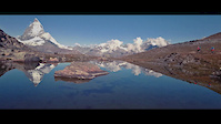
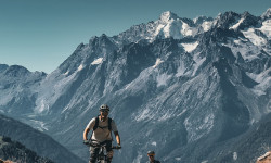
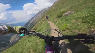
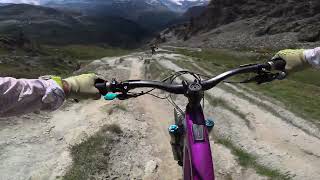
Surrounded by 38 mountain peaks over 4,000 m, the destination of Zermatt - Matterhorn is a mountain bike paradise at the foot of the Matterhorn. Ideal for children and beginners to learn mountain biking – perfect for advanced riders to refine their technique. There is something here for everyone.
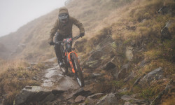
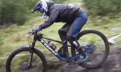
With their heights between 1,400 m and 3,100 m, the mountains around Zermatt offer a wide range of trails. With a lot of flow or steep and technical or natural or graded. The choice of all-day mountain bike tours or short afternoon rides offers everything your heart desires. The combination of riding and the unique mountain scenery of the Alps guarantees an unforgettable mountain bike experience.
GUIDELINES FOR MOUNTAINBIKERS
Mountain bikers are allowed to ride on all roads, unless a prohibition sign forbids their passage. This means that there is a potential for conflicts with other route users. The destination therefore asks for consideration and peaceful coexistence on the paths in and around Zermatt, Täsch and Randa.
1 – Side-by-side.
Respect others using the paths and trails (trail tolerance)
Forward-looking riding and take the unexpected into consideration
Avoid heavily used path sections when riding fast
2 – Environment.
Protect nature
Do note leave tracks behind
Close meadow gates after going through
3 – Safety.
Use good and proper equipment
Plane a tour carefully
Check the weather and weather forecast before setting out
---
Umgeben von 38 Berggipfeln über 4'000 m ist Zermatt das Mountainbike-Paradies am Fusse des Matterhorns. Ideal für Kinder und Anfänger, das Mountainbiken zu erlernen – perfekt für Fortgeschrittene, ihre Technik zu verfeinern. Hier gibt es das Richtige für jeden.
Zwischen 1’400 und 3’100 m bieten die Berge rund um Zermatt eine grosse Bandbreite an Trails. Sei es mit viel Flow oder steil und technisch, naturbelassen oder geshaped. Die Auswahl an ganztägigen Bike-Touren oder kurzen Nachmittagsrunden bietet alles, was das Herz begehrt. In Kombination mit der einmaligen Bergkulisse der Alpen ist ein unvergessliches Mountainbike-Erlebnis garantiert.
RICHTLINIEN FÜR MOUNTAINBIKER
Mountainbikern ist die Fahrt auf allen Wegen erlaubt, sofern kein Verbotsschild die Durchfahrt untersagt. Dies birgt Konfliktpotential mit anderen Wegnutzern. Die Destination bittet daher um Rücksicht und ein friedliches Miteinander auf den Wegen in und rund um Zermatt, Täsch und Randa.
1 – Nebeneinander..
Andere Wegbenützer respektieren (Trail-Toleranz)
Vorausschauend fahren und mit dem Unvorhergesehenen rechnen
Stark frequentierte Wegabschnitte zu Spitzenzeiten meiden
2 – Umwelt.
Die Natur schonen
Keine Spuren hinterlassen
Weidezäune nach der Durchfahrt wieder schliessen
3 – Sichereit.
Sich gut ausrüsten
Tour gewissenhaft planen
Sich über die Wettervorhersage informieren
---
Environné par 38 sommets de plus de 4’000 mètres, la destination Zermatt – Matterhorn est véritablement un paradis du VTT au pied du Cervin. Pour les enfants et les débutants, c'est le lieu idéal pour apprendre et pour les avancés, pour améliorer leur technique. Ici, chacun trouve son bonheur.
Les montagnes qui entourent Zermatt regorgent de pistes pour vélo de montagne à des altitudes allant de 1’400 à 3’100 mètres. Particulièrement bien aménagées ou raides et très techniques, naturelles ou balisées. L'offre en randonnées cyclistes d'une demi-journée ou d'une journée entière est si grande qu'il est facile de répondre à toutes les attentes. Associée aux coulisses uniques des Alpes, tout est réuni pour procurer des expériences inoubliables.
REGLES DE CONDUITE POUR LES MOUNTAINBIKERS
Les cyclistes sont autorisés à emprunter tous les sentiers dans la mesure où aucun panneau ne l'interdit formellement. Par conséquent, cela peut être une source de conflits avec des promeneurs et la destination demande de ce fait à tous les usagers de se montrer respectueux d'autrui afin d'assurer une coexistence paisible sur tous les sentiers dans et autour de Zermatt, Täsch et Randa.
1 – Vivre ensemble.
Respecter les autres utilisateurs des sentiers (principe de coexistence)
Conduire prudemment et anticiper l’imprévu
Éviter les tronçons les plus fréquentés aux heures de forte affluence
2 – Environnement.
Ménager la nature
Ne pas laisser de trace
Refermer les barrières des pâturages après avoir traversé
3 – Sécurité.
Bien s'équiper
Planifier consciencieusement la course
S'informer des conditions météo
Surrounded by 38 mountain peaks over 4,000 m, the destination of Zermatt - Matterhorn is a mountain bike paradise at the foot of the Matterhorn. Ideal for children and beginners to learn mountain biking – perfect for advanced riders to refine their technique. There is something here for everyone.
With their heights between 1,400 m and 3,100 m, the mountains around Zermatt offer a wide range of trails. With a lot of flow or steep and technical or natural or graded. The choice of all-day mountain bike tours or short afternoon rides offers everything your heart desires. The combination of riding and the unique mountain scenery of the Alps guarantees an unforgettable mountain bike experience.
GUIDELINES FOR MOUNTAINBIKERS
Mountain bikers are allowed to ride on all roads, unless a prohibition sign forbids their passage. This means that there is a potential for conflicts with other route users. The destination therefore asks for consideration and peaceful coexistence on the paths in and around Zermatt, Täsch and Randa.
1 – Side-by-side.
Respect others using the paths and trails (trail tolerance)
Forward-looking riding and take the unexpected into consideration
Avoid heavily used path sections when riding fast
2 – Environment.
Protect nature
Do note leave tracks behind
Close meadow gates after going through
3 – Safety.
Use good and proper equipment
Plane a tour carefully
Check the weather and weather forecast before setting out
---
Umgeben von 38 Berggipfeln über 4'000 m ist Zermatt das Mountainbike-Paradies am Fusse des Matterhorns. Ideal für Kinder und Anfänger, das Mountainbiken zu erlernen – perfekt für Fortgeschrittene, ihre Technik zu verfeinern. Hier gibt es das Richtige für jeden.
Zwischen 1’400 und 3’100 m bieten die Berge rund um Zermatt eine grosse Bandbreite an Trails. Sei es mit viel Flow oder steil und technisch, naturbelassen oder geshaped. Die Auswahl an ganztägigen Bike-Touren oder kurzen Nachmittagsrunden bietet alles, was das Herz begehrt. In Kombination mit der einmaligen Bergkulisse der Alpen ist ein unvergessliches Mountainbike-Erlebnis garantiert.
RICHTLINIEN FÜR MOUNTAINBIKER
Mountainbikern ist die Fahrt auf allen Wegen erlaubt, sofern kein Verbotsschild die Durchfahrt untersagt. Dies birgt Konfliktpotential mit anderen Wegnutzern. Die Destination bittet daher um Rücksicht und ein friedliches Miteinander auf den Wegen in und rund um Zermatt, Täsch und Randa.
1 – Nebeneinander..
Andere Wegbenützer respektieren (Trail-Toleranz)
Vorausschauend fahren und mit dem Unvorhergesehenen rechnen
Stark frequentierte Wegabschnitte zu Spitzenzeiten meiden
2 – Umwelt.
Die Natur schonen
Keine Spuren hinterlassen
Weidezäune nach der Durchfahrt wieder schliessen
3 – Sichereit.
Sich gut ausrüsten
Tour gewissenhaft planen
Sich über die Wettervorhersage informieren
---
Environné par 38 sommets de plus de 4’000 mètres, la destination Zermatt – Matterhorn est véritablement un paradis du VTT au pied du Cervin. Pour les enfants et les débutants, c'est le lieu idéal pour apprendre et pour les avancés, pour améliorer leur technique. Ici, chacun trouve son bonheur.
Les montagnes qui entourent Zermatt regorgent de pistes pour vélo de montagne à des altitudes allant de 1’400 à 3’100 mètres. Particulièrement bien aménagées ou raides et très techniques, naturelles ou balisées. L'offre en randonnées cyclistes d'une demi-journée ou d'une journée entière est si grande qu'il est facile de répondre à toutes les attentes. Associée aux coulisses uniques des Alpes, tout est réuni pour procurer des expériences inoubliables.
REGLES DE CONDUITE POUR LES MOUNTAINBIKERS
Les cyclistes sont autorisés à emprunter tous les sentiers dans la mesure où aucun panneau ne l'interdit formellement. Par conséquent, cela peut être une source de conflits avec des promeneurs et la destination demande de ce fait à tous les usagers de se montrer respectueux d'autrui afin d'assurer une coexistence paisible sur tous les sentiers dans et autour de Zermatt, Täsch et Randa.
1 – Vivre ensemble.
Respecter les autres utilisateurs des sentiers (principe de coexistence)
Conduire prudemment et anticiper l’imprévu
Éviter les tronçons les plus fréquentés aux heures de forte affluence
2 – Environnement.
Ménager la nature
Ne pas laisser de trace
Refermer les barrières des pâturages après avoir traversé
3 – Sécurité.
Bien s'équiper
Planifier consciencieusement la course
S'informer des conditions météo
source: www.zermatt.ch
AKA: Zermatt Matterhorn
Disclaimer:
SUMMER 2020 - BIKE TRANSPORT WITH THE GORNERGRAT BAHN IS ONLY FROM 4PM (16:00)
This region uses the Uk/Euro style trail grading system.
Activities Click to view
- Mountain Bike
167 trails
- E-Bike
166 trails
- Hike
191 trails
- Trail Running
194 trails
- Snowshoe
0 trails
- Downhill Ski
48 trails
- Backcountry Ski
5 trails
- Nordic Ski
0 trails
Region Details
- 6
- 29
- 63
- 44
- 11
- 1
Region Status
Open as of Jul 6, 2026Stats
- Avg Trail Rating
- Trails (view details)
- 240
- Trails Mountain Bike
- 167
- Trails E-Bike
- 166
- Trails Hike
- 194
- Trails Trail Running
- 194
- Trails Downhill Ski
- 48
- Trails Backcountry Ski
- 5
- Total Distance
- 166 miles
- Total Descent
- 106,154 ft
- Total Vertical
- 7,814 ft
- Highest Trailhead
- 12,613 ft
- Reports
- 2,756
- Photos
- 280
- Ridden Counter
- 63,642
Articles
The Haute Route: Chasing the Spine of the Alps from Verbier to Zermatt
Nov 24, 2025 from pinkbike.com
Big climbs, bigger views, and the kind of descents that erase the memory of every hike-a-bike.

XCC Photo Epic: 2025 Zermatt World Championships
Sep 10, 2025 from pinkbike.com
Rainbow stripes were decided in the shadow of the Matterhorn.
Video: Behind the Scenes of Jesse Melamed's EWS Win in Zermatt - The Jank Files
Sep 4, 2020 from pinkbike.com
The Jank files is back for an in-depth look at a dramatic week for Jesse, Remi and ALN.
Sub Regions
-
Zermatt - Matterhorn
- 29
- 64
- 44
- 11
- 1
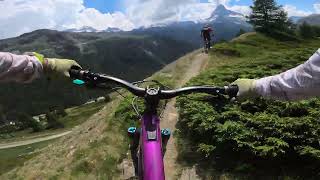
Popular Zermatt Mountain Biking Trails
• 100 ★ 3.8 • 3 miles • 168 ft • 617 •
"Flow and fun are among the main attractions of the new – for beginners and pros alike. You’ll definitely want to ride it more than once. The is easily reached by rail: in Zermatt just take the funicular up to Sunnegga. Once at the...
• 100 ★ 3.7 • 3,694 ft • 35 ft • 604 •
The Kate is a very short family friendly flowtrail between Furi and Unter- . Access road via the paved road Winkelmatten-Furi or directly with the gondola (Furi mid-station). --- Der Kate- -Trail ist ein sehr kurzer familienfreundlicher...
• 95 ★ 3.7 • 2,405 ft • 0 ft • 569 •
Popular green difficulty family friendly dirt/gravel road. This multi-use trail can be used downhill primary and has a easy overall physical rating with a 0 ft green climb. Trail visibility is always easy to follow. On average it takes 3 minutes to complete this trail.
• 100 ★ 4.8 • 4,117 ft • 0 ft • 363 •
Highly rated popular blue difficulty alpine singletrack. This multi-use trail can be used downhill primary and has a moderate overall physical rating with a 0 ft green climb. Trail visibility is always easy to follow. On average it takes 9 minutes to complete this trail.
• 100 ★ 3.9 • 2 miles • 309 ft • 342 •
The singletrack is a great way to get back to Täsch or transit to Visp at the end of a riding day. A good mix of short climbs alternated with small "flowy" segments. You can climb from Täsch to Zermatt, some steep parts at the start...
• 95 ★ 4.0 • 1 mile • 156 ft • 300 •
The Yo - Yo Trail is a locals classic. Nice and flowy but with many blind corners and some exposure. Be careful about the hikers in both directions.
• 85 ★ 4.0 • 3,907 ft • 0 ft • 297 •
Highly rated popular red difficulty singletrack. This multi-use trail can be used downhill primary and has a moderate overall physical rating with a 0 ft green climb. Trail visibility is always easy to follow. On average it takes 7 minutes to complete this trail.
• 90 ★ 4.2 • 2,362 ft • 20 ft • 282 •
Highly rated popular blue difficulty alpine singletrack. This multi-use trail can be used downhill primary and has a moderate overall physical rating with a 20 ft green climb. Trail visibility is always easy to follow. On average it takes 4 minutes to complete this trail.
Zermatt Mountain Bike Routes
★ 4.5 • 7 miles • 63 ft • 10 • Point to Point •
Classic (Nr. 1) Bahn up to the . Before heading off on the bike trail, take in the breathtaking views of...
★ 4.0 • 16 miles • 3,887 ft • 15 •
Start from Zermatt Town strait up to Sunegga. It's a steep and steady climb on gravel roads that leads you...
10 miles • 1,910 ft • 1 • Point to Point •
From Zermatt, you head up towards Furi on Moosstrasse. When you reach Schweigmatten, the path branches off...
3 miles • 293 ft • 3 • Loop •
The cable cars take you up to Blauherd. The trail to Tufteren heads left away from Blauherd station and is...
★ 3.0 • 12 miles • 1,094 ft • 7 • Point to Point •
offers everything that mountain bikers could wish for, including fabulous views and a trail full of...
4 miles • 35 ft • 6 • Point to Point •
Due to the altitude, this trail can only be ridden in the late summer season (depending on when the snow...
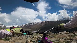
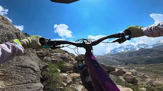
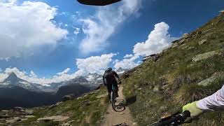
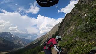
Photos of Zermatt Mountain Bike
Videos of Zermatt Mountain Bike
trail: Blauherd - Stellisee
4:05 |
8 |
Jul 1, 2026 , Zermatt
trail: Meisterswang
4:21 |
5 |
Jul 1, 2026 , Zermatt
trail: Findelalp
4:03 |
13 |
Jul 1, 2026 , Zermatt
trail: Europaweg - Galen
3:41 |
7 |
Jul 1, 2026 , Zermatt
trail: Chüebord - Bordercross
2:43 |
6 |
Jul 1, 2026 , Zermatt
trail: Europaweg - Galen
2:55 |
12 |
Jul 1, 2026 , Zermatt
trail: Findelalp
3:14 |
5 |
Jul 1, 2026 , Zermatt
trail: Unner Furggegga
17:30 |
25 |
Jan 6, 2026 , Zermatt
Recent Trail Reports
| status | trail | date | condition | info | user |
|---|---|---|---|---|---|
| Furggji - Tufterchumme | Jul 6, 2026 @ 1:05pm (Europe/Zurich) Jul 6, 2026 | Dry | brunomartins83 | ||
| Europaweg - Galen | Jul 1, 2026 @ 10:16am (Europe/Zurich) Jul 1, 2026 | Ideal | Grzesfajny | ||
| Gsäss | Jun 27, 2026 @ 10:56am (Europe/Zurich) Jun 27, 2026 | Dry | Horeschlittae | ||
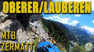
| Lauberen | Jun 27, 2026 @ 10:56am (Europe/Zurich) Jun 27, 2026 | Ideal | Horeschlittae | ||
| Ze Seewjinen - Börter | Jun 27, 2026 @ 10:56am (Europe/Zurich) Jun 27, 2026 | Dry | Horeschlittae | ||
| Zermatt - Täsch | Jun 16, 2026 @ 5:24pm (Europe/Zurich) Jun 16, 2026 | Dry | brunomartins83 | ||
| Beetschi | Sep 6, 2025 @ 9:11am Sep 6, 2025 | Ideal | freerider48 TRAILFORKS | ||
| Meiggra | Sep 6, 2025 @ 9:11am Sep 6, 2025 | Ideal | freerider48 TRAILFORKS | ||
| Patrullarve - Tufternalp | Sep 6, 2025 @ 9:11am Sep 6, 2025 | Ideal | freerider48 TRAILFORKS | ||
| Blauherd C1 | Sep 6, 2025 @ 9:11am Sep 6, 2025 | Ideal | freerider48 TRAILFORKS |
Activity Feed
| username | action | type | title | date |
|---|---|---|---|---|
| cadmortess | comment | trail | activity #98774399 | Jul 9, 2026 @ 4:08am 3 days |
| Carou | wishlist | trail | activity #98769828 | Jul 9, 2026 @ 1:25am 3 days |
| Carou | wishlist | route | activity #98769772 | Jul 9, 2026 @ 1:23am 3 days |
| HalvardIb3Ugk | wishlist | route | activity #98769016 | Jul 9, 2026 @ 12:52am 3 days |
| Carou | wishlist | trail | activity #98697974 | Jul 8, 2026 @ 1:46am Jul 8, 2026 |
Recent Comments
| username | type | title | comment | date |
|---|---|---|---|---|
| trail | This trail is no longer a MTB trail. Overgrown... | Jul 9, 2026 @ 4:08am 3 days | ||
| trail | Decent trail. It is mostly a hiking trail... | Jun 25, 2026 @ 12:07pm Jun 25, 2026 | ||
| trail | A fun cruisy easy flow trail. No bumps or... | Jun 25, 2026 @ 12:04pm Jun 25, 2026 | ||
| trail | This is a horrible trail, don't ride it. It's... | Jun 25, 2026 @ 11:59am Jun 25, 2026 | ||
| trail | A cruisy easy flow trail with lots of berms.... | Jun 25, 2026 @ 11:54am Jun 25, 2026 |
Local Badges
-

10 Black Trails7 awarded -

Epic Ride 50k236 awarded -

Big Ride 30k747 awarded -

10 Green Trails121 awarded -

Top 10 Trails0 awarded -

Completionist0 awarded
Bike & Skill Parks
| name | type | city | rating |
|---|---|---|---|
| Zermatt - Matterhorn | bike park | Zermatt | |
| Pumptrack Zermatt | skill park | Zermatt |
Activity Type Stats
| activitytype | trails | distance | descent | descent distance | total vertical | rating | global rank | state rank | photos | reports | routes | ridelogs |
|---|---|---|---|---|---|---|---|---|---|---|---|---|
| Mountain Bike | 167 | 86 miles | 51,686 ft | 61 miles | 5,344 ft | #638 | #4 | 279 | 2,757 | 20 | 4,515 | |
| E-Bike | 166 | 85 miles | 51,312 ft | 61 miles | 5,344 ft | #425 | #45 | 1 | 2,754 | 13 | 637 | |
| Hike | 191 | 111 miles | 65,430 ft | 71 miles | 6,335 ft | #472 | #11 | 2,744 | 4 | 2,350 | ||
| Trail Running | 194 | 111 miles | 65,430 ft | 71 miles | 6,335 ft | #429 | #11 | 2,744 | 3 | 527 | ||
| Downhill Ski | 48 | 44 miles | 36,578 ft | 42 miles | 7,221 ft | #45 | #3 | 1,062 | 5,645 | |||
| Backcountry Ski | 5 | 7 miles | 1,621 ft | 4 miles | 7,057 ft | #58 | #4 | 1,062 | 1,127 |
Frequently Asked Questions About Zermatt
▼
What are the best places to ride in Zermatt?
Zermatt has 2 areas to explore for mountain biking. The top rated areas are:
▼
What are the highest rated mountain biking trails in Zermatt?
The highest rated mountain biking trails in Zermatt are:
- Europaweg - Bidemjini (4.6/5)
- Lichenbretter (4.6/5)
- Ze Seewjinen - Börter (4.5/5)
- Gornergrat (4.5/5)
- Lauberen (4.5/5)
▼
What is the best time of the year to ride in Zermatt?
Based on ride log data, the most popular months to ride in Zermatt are:
- July (78 activities)
- August (69 activities)
- September (39 activities)
▼
Where can I park to ride in Zermatt?
There are 1 parking locations listed in Zermatt. The most popular parking spots are:
Activities
Trails
Points of Interest
- By EliSchroppel & contributors
- Admins: VS-Admin, VS-Admin
- #17616 - 38,867 views
- zermatt activity log | embed map of Zermatt mountain bike trails | zermatt mountain biking points of interest polygons
Downloading of trail gps tracks in kml & gpx formats is enabled for Zermatt.
You must login to download files.