more stats
938 ft
Distance
-251 ft
Descent
00:04:34
Avg time
-251 ft
Altitude change
1,390 ft
Altitude min
1,642 ft
Altitude max
1,642 ft
Altitude start
1,391 ft
Altitude end
-26.8%
Grade
-50.5%
Grade max
-10%
Grade min
938 ft
Distance down
00:04:34
Avg time

Executioner BP Exit Details

  • Activities
    • Mountain Bike
    • E-Bike
    • Hike
    • Trail Running
  • Riding Area
    Mount Fromme
    North Vancouver, British Columbia
  • Difficulty Rating
  • Local Popularity
    55 in Mountain Biking [+]
    • 40 in E-Biking
    • 60 in Trail Running
    • 75 in Hiking
  • Global Ranking
    #103136 in Mountain Biking [+]
    • #87071 in E-Biking
    • #98869 in Trail Running
    • #72885 in Hiking
  • Trail Type
    Singletrack
  • Bike Type
    DH, AM
  • Dogs Allowed
    Yes
  • eBike Allowed
  • Land Owner
    District of North Vancouver

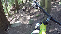
Fun original technically challenging ending to Executioner trail. Put's you out a fair way down the Baden Powell so be prepared for a long traverse back if you are parked in the main Fromme parking lot.

Access Info

Enter off of upper dreamweaver

Trail Supporters
Local Trail Association

Recent Activity on Trail

Past Week
  • 3 rides
  • 40 miles average
6 Months
  • 11 rides
  • 19 miles avg distance
All
  • 315 rides
  • Last: Jun 20, 2026
c1c2c3c4
January
February
March
April
May
June
July
August
September
October
November
December
update trails status or condition

Executioner BP Exit Trail Reports

statusdatedescription
May 11, 2026 @ 4:24pm (America/Vancouver)
May 11, 2026
Jul 31, 2025 @ 10:04am
Jul 31, 2025
Gnarly, janky and fun, watch for loose rocks
Nov 17, 2024 @ 10:18am
Nov 17, 2024
Apr 14, 2024 @ 3:51am
Apr 14, 2024
reporter First time on here: it’s pretty chunky, but maybe that’s how it’s meant to be!
Nov 11, 2023 @ 12:35pm
Nov 11, 2023
reporter
more »
Status:
on May 11, 2026
Ideal
Avg: 3.76 (7 votes)
Your vote: 0

view (1,610)
close
3D
Trail Conditions
  • Unknown
  • Snow Groomed
  • Snow Packed
  • Snow Covered
  • Snow Cover Partial
  • Freeze/thaw Cycle
  • Icy
  • Prevalent Mud
  • Wet
  • Variable
  • Ideal
  • Dry
  • Very Dry
Trail Flow (Ridden Direction)
Trailforks scans users ridelogs to determine the most popular direction each trail is ridden. A good flowing trail network will have most trails flowing in a single direction according to their intension.
The colour categories are based on what percentage of riders are riding a trail in its intended direction.
  • > 96%
  • > 90%
  • > 80%
  • > 70%
  • > 50%
  • < 50%
  • bi-directional trail
  • no data
Trail Last Ridden
Trailforks scans ridelogs to determine the last time a trail was ridden.
  • < 2 days
  • < 1 week
  • < 2 weeks
  • < 1 month
  • < 6 months
  • > 6 months
Trail Ridden Direction
The intended direction a trail should be ridden.
  • Downhill Only
  • Downhill Primary
  • Both Directions
  • Uphill Primary
  • Uphill Only
  • One Direction
Contribute Details
Colors indicate trail is missing specified detail.
  • Description
  • Photos
  • Description & Photos
  • Videos
Trail Popularity ?
Trailforks scans ridelogs to determine which trails are ridden the most in the last 9 months. Trails are compared with nearby trails in the same city region with a possible 25 colour shades. Think of this as a heatmap, more rides = more kinetic energy = warmer colors.
  • most popular
  • popular
  • less popular
  • not popular
ATV/ORV/OHV Filter
Max Vehicle Width
inches
US Cell Coverage
Legend
cell carrier legend

Radar Time
Activity Recordings
Trailforks uses anonymized public activity data. ?
Activity Recordings
Trailforks uses anonymized public activity data. ?
Personal Heatmap
Activity Types
all / none
Options
2
Date range month
Winter Trails
Warning A routing network for winter maps does not exist. Selecting trails using the winter trails layer has been disabled.
Missing Trails
Most Popular
Least Popular
Trails are colored based on popularity. The more popular a trail is, the more red. Less popular trails trend towards green.
Jump Magnitude Heatmap
Heatmap of where riders jump on trails. Zoom in to see individual jumps, click circles to view jump details.
BC Backroad Status

Service Road Atlas is a free to use, community-driven service for viewing and creating reports on the numerous back-country service roads around B.C. and Alberta.

map legend
Slope Aspect
Direction the slope faces
Flat N NE E SE S SW W NW
Trails Deemphasized
Trails are shown in grey.
disable
Only show trails with no bike usage.
Enable
Suggested Layers
Based on selected activity type

    Save the current map location and zoom level as your default home location whenever this page is loaded.

    Save
        Directions to executioner-bp-exit trailhead (49.356600, -123.071190)

        Photos

        6 more »
        76 |
        Dec 6, 2023 @ 9:35am
        Dec 6, 2023
        51 |
        Sep 27, 2023 @ 12:20am
        Sep 27, 2023
        40 |
        Aug 19, 2023 @ 6:14pm
        Aug 19, 2023
        48 |
        Oct 14, 2022 @ 12:11pm
        Oct 14, 2022

        Videos

        2 more »
        North Shore Chonk | Executioner - Fromme
        7:30 | 63 | Nov 29, 2024 , North Vancouver
        Executioner BP Exit
        2:14 | 375 | May 21, 2017 , North Vancouver

        Trail Lists

        3 Reviews & Comments


        We hope you've been enjoying Trailforks!

        Create a FREE account to view trail comments and much more.

        • By canadakaTF Pro Trailforks & contributors
        • #3437 - 4,325 views

        Frequently Asked Questions About Executioner BP Exit

        Where is Executioner BP Exit located?
        Executioner BP Exit is located in Mount Fromme, North Vancouver, British Columbia, Canada. It is part of the Mount Fromme trail network. The trailhead is located at coordinates 49.3566, -123.07119.
        How hard is Executioner BP Exit?
        Executioner BP Exit is rated as Black Diamond difficulty. The average grade is 26.8%.
        What is the elevation gain for Executioner BP Exit?
        The trail has 251 ft of elevation descent. The elevation ranges from 1,390 ft to 1,642 ft.
        How long is Executioner BP Exit?
        Executioner BP Exit is 938 ft long. The trail type is singletrack.

        Hit the Trail

        Open in App

        Get this trail on your phone instantly.
        open trail in app

        Download Trail

        Save to wishlist, Garmin & download.
        save the trail

        Find Related Routes

        Find routes and users activities that include this trail.
        find routes for this trail

        You must enter a description before submitting.